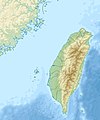
File:Taiwan relief location map.jpg

Dosyeya orjînal (1016 × 1222 pixel, mezinbûnê data: 101 KB, MIME-typ: image/jpeg)
Captions
Captions

|
This file requires updating because: The earlier forms of this map did not extend a dotted-line around Dongyin, Lienchiang (Tungyin). The northern edge of this map ought to be moved up a little bit (in latitude) so that a dotted line encompassing Dongyin (Tungyin) can be clearly drawn and so that we can see a few of the islands north of Lienchiang County in Haidao Township, PRC. Example of a better map from The Economist: [1]. In doing so, you could add a timestamp to the file.
|
Danasîn[biguhêre]
| DanasînTaiwan relief location map.jpg |
English: Relief location map of Taiwan.
|
| Dîrok | |
| Çavkanî | Min çêkir |
| Xwedî | Uwe Dedering |
Lîsans[biguhêre]
- Tu azad î:
- parve bike – ji bo kopîkirin, belavkirin û weşandina xebatê
- ji bo guhartin û adaptekirina naverokê – ji bo adaptekirina xebatê
- Di bin van mercan de:
- isnad – Divê tu isnadeke maqûl bikî, lînekek pêşkêş bikî ji bo lîsansê, û diyar bikî ku guhartin hatiye kirin an na. Tu dikarî vê yekê bi adilî bi cih bînî, lê ne bi awayê ku wekî lîsansor te an bikaranîna te pejirandibe.
- parvekirinê mîna hev – Ger tu materyalê biguherînî, bizivirînî formeke din, an ava bikî divê beşdariyên xwe di bin eynî lîsansê an lîsansa hevaheng de wekî ya eslî belav bikî.

|
Ev dosye di bin Lîsansa Belgekirina Azad a GNU hate barkirin.
Kopîkirin, belavkirin û guhartin di bin qebûlkirinên lîsansa GNU de ye, versiyona 1.2 versiyoneke kevintirîn a belavkirinê ya ji bo Weqfa Nivîsbara Azad, tê qebûlkirin. Kopyeyek lîsanse di beşa bi sernavê Lîsansa Belgekirina Azad a GNUde cî digre.http://www.gnu.org/copyleft/fdl.htmlGFDLGNU Free Documentation Licensetruetrue |
Dîroka daneyê
Ji bo dîtina guhartoya wê demê bişkoka dîrokê bitikîne.
| Dîrok/Katjimêr | Wêneyê biçûk | Mezinahî | Bikarhêner | Şirove | |
|---|---|---|---|---|---|
| niha | 14:01, 19 îlon 2019 |  | 1016 x 1222 (101 KB) | Geographyinitiative (gotûbêj | beşdarî) | temporary fix: extending the boundary out around Dongyin Township (as in China Fujian2 location map.svg and as in File:Nationalist China - administrative divisons. LOC 2007633622.jpg) |
| 17:09, 3 tebax 2019 |  | 1016 x 1222 (537 KB) | NordNordWest (gotûbêj | beşdarî) | border corrections | |
| 01:51, 3 tebax 2019 |  | 1016 x 1222 (96 KB) | Geographyinitiative (gotûbêj | beşdarî) | Proposed removal of three dashes (markers of the approximate PRC/ROC maritime boundary) which seemed to put Dadan Island, Erdan Island and Binlang Islet (檳榔嶼) outside the territory of Kinmen County, Taiwan/ROC. This is not the optimal form of the map, but is merely a quick removal of incorrect information. In the optimal situation, the line needs to be redrawn in the correct location, but I don't have the technical skill to produce such a map. (Basis: [http://ws.mac.gov.tw/001/Upload/OldFile/... | |
| 00:30, 3 tebax 2019 |  | 1016 x 1222 (96 KB) | Geographyinitiative (gotûbêj | beşdarî) | Proposed removal of two dashes (markers of the approximate PRC/ROC maritime boundary) which seemed to put {{w|Dadan Island}} and {{w|Erdan Island}} outside the territory of {{w|Kinmen County}}, Taiwan/ROC. | |
| 17:22, 28 kanûna pêşîn 2010 |  | 1016 x 1222 (452 KB) | Uwe Dedering (gotûbêj | beşdarî) | {{Information |Description={{en|1=Relief location map of Taiwan. * Projection: Equirectangular projection, strechted by 110.0%. * Geographic limits of the map: :* N: 26.4° N :* S: 21.7° N :* W: 118.0° E :* E: 122.3° E * GMT projection: -JX17.204266666 |
Tu nikarî cardin li ser vê dosyeyê binivîsînî.
Bikaranîna pelê
Ev rûpelên li jêr vê dosyeyê bi kar tînin:
Bikaranîna gerdûnî ya pelê
Ev wîkiyên di rêzê de vê pelê bi kar tînin:
- Bikaranîna di ar.wikipedia.org de
- Bikaranîna di ast.wikipedia.org de
- Bikaranîna di az.wikipedia.org de
- Bikaranîna di ba.wikipedia.org de
- Bikaranîna di bcl.wikipedia.org de
- Bikaranîna di be.wikipedia.org de
- Bikaranîna di bn.wikipedia.org de
- Bikaranîna di bs.wikipedia.org de
- Bikaranîna di ceb.wikipedia.org de
- Bikaranîna di ce.wikipedia.org de
- Bikaranîna di ckb.wikipedia.org de
- Bikaranîna di de.wikipedia.org de
- Bikaranîna di de.wikivoyage.org de
Zêdetir bikaranîna global a vê pelê bibîne.
Daneyên meta
Dosye zêdetir agahiyan dihewîne, mihtemelen ji kamera an skennira dijîtal hatine ku ji bo çêkirin an dîjîtalîzekirina wan hatine bikaranîn.
Ger dosye ji halê xwe yê eslî hatibe guhartin, dibe ku hin detay bi temamî neyên xuya li ser dosyeya guhartî.
| Panbûn | 1016 px |
|---|---|
| Dirêjbûn | 1222 px |
| Bits per component |
|
| Pixel composition | RGB |
| Beralîkirin | Normal |
| Number of components | 3 |
| Averûtiya asoyî | 72 dpi |
| Averûtiya stûnî | 72 dpi |
| Bernameya bikarhatî | Adobe Photoshop CS6 (Macintosh) |
| Roj û wextê guhartina dosyeyê | 19:08, 3 tebax 2019 |
| Versiyona exif | 2.21 |
| Navbera rengê | Uncalibrated |