File:Taki Mountains.png
Jump to navigation
Jump to search

Size of this preview: 800 × 533 pixels. Other resolutions: 320 × 213 pixels | 640 × 427 pixels | 1,024 × 683 pixels | 1,280 × 853 pixels | 1,800 × 1,200 pixels.
Original file (1,800 × 1,200 pixels, file size: 1.7 MB, MIME type: image/png)
Captions
Captions
Add a one-line explanation of what this file represents
Summary
[edit]
| Description |
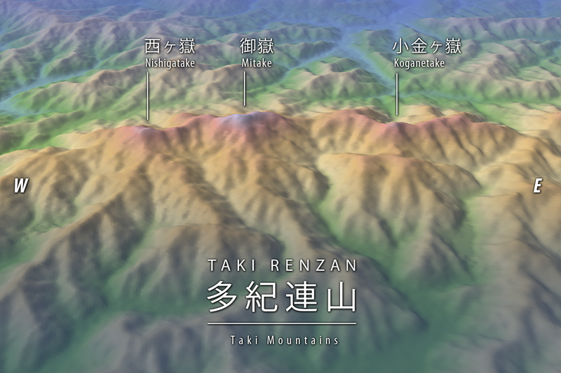
日本語: 兵庫県の多紀連山の主峰たち。 |
| Date | |
| Source |
Topographic data: NASA's SRTM-1 30m Mesh (ver.3 2014) |
| Author | Batholith |
| Object location | | View this and other nearby images on: OpenStreetMap |
|---|
Licensing
[edit]
| I, the copyright holder of this work, release this work into the public domain. This applies worldwide. In some countries this may not be legally possible; if so: I grant anyone the right to use this work for any purpose, without any conditions, unless such conditions are required by law. |
This image uses high-resolution digital topography data from NASA's Shuttle Radar Topography Mission (SRTM) at JPL-Caltech [1]. It is in the public domain in the United States.
|
 | |
File history
Click on a date/time to view the file as it appeared at that time.
| Date/Time | Thumbnail | Dimensions | User | Comment | |
|---|---|---|---|---|---|
| current | 04:30, 28 June 2020 | | 1,800 × 1,200 (1.7 MB) | Batholith (talk | contribs) | == {{int:filedesc}} == {{Information |description = {{en|Main redge of the Taki Mountains in Hyogo Prefecture, Honshu, Japan.}} {{ja|兵庫県の多紀連山の主峰たち。}} |source = Topographic data: NASA's [http://www2.jpl.nasa.gov/srtm/ SRTM]-1 30m Mesh (ver.3 2014)<br /> Rendering software: [http://www.kashmir3d.com/ KASHMIR 3D] |author = Batholith |date = 2020-6-28 |permission = |other_versions = }}... |
You cannot overwrite this file.
File usage on Commons
There are no pages that use this file.
File usage on other wikis
The following other wikis use this file:
- Usage on ja.wikipedia.org