File:Tanzania (MODIS).jpg
Jump to navigation
Jump to search

Size of this preview: 783 × 599 pixels. Other resolutions: 314 × 240 pixels | 627 × 480 pixels | 1,004 × 768 pixels | 1,280 × 980 pixels | 2,560 × 1,959 pixels | 3,508 × 2,685 pixels.
Original file (3,508 × 2,685 pixels, file size: 5.09 MB, MIME type: image/jpeg)
Captions
Captions
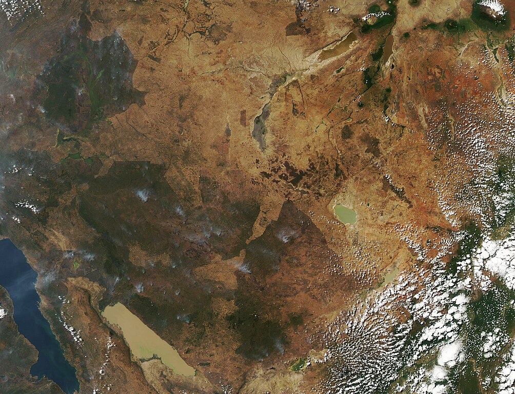
With a land area spanning roughly 885,800 square miles (2.9 million sq km), Tanzania sprawls across Eastern Africa.
Summary
[edit].jpg&action=edit§ion=1)
| Description |
English: With a land area spanning roughly 885,800 square miles (2.9 million sq km), Tanzania sprawls across Eastern Africa. From the border with Democratic Republic in the west to its eastern islands (Mafia, Pemba, and Zanzibar) in the Indian Ocean, the country’s landscape varies widely to include the Great Rift Valley (west), the central plateau, the coastal plain, and a mountainous north. A few of the things that makes Tanzania is notable is an amazing variety of lakes, iconic big game parks, and its diverse geology, which includes diamonds and gemstones. The intensely colored violet-blue gemstone called tanzanite is only found in Tanzania and is said to be much rarer than either diamonds or sapphire.
The Moderate Resolution Imaging Spectroradiometer (MODIS) on board NASA’s Aqua satellite acquired a true-color image that captured much of Tanzania on July 20, 2023. Lake Tanganyika, which is shared by the Democratic Republic of Congo, is visible in the far west. The rugged heights of the Great Rift Valley separates Tanganyika and mud-colored Lake Rukwa. Green patches mark agricultural regions as well as several parks that provide homes for big game animals and drive the economically-important tourism industry. Plumes of smoke in these areas suggests that agricultural burning, which is common at this time of year, is taking place. The nearly-round Lake Sulunga sits only about 45 km (30 miles) of Dodoma, the capital city of Tanzania. Dodoma is not easily visible in this image. |
||
| Date | Taken on 20 July 2023 | ||
| Source |
|
||
| Author | MODIS Land Rapid Response Team, NASA GSFC |
| This media is a product of the Aqua mission Credit and attribution belongs to the mission team, if not already specified in the "author" row |
Licensing
[edit].jpg&action=edit§ion=2)
| This file is in the public domain in the United States because it was solely created by NASA. NASA copyright policy states that "NASA material is not protected by copyright unless noted". (See Template:PD-USGov, NASA copyright policy page or JPL Image Use Policy.) | ||
 |
Warnings:
|
File history
Click on a date/time to view the file as it appeared at that time.
| Date/Time | Thumbnail | Dimensions | User | Comment | |
|---|---|---|---|---|---|
| current | 18:12, 31 July 2023 | | 3,508 × 2,685 (5.09 MB) | OptimusPrimeBot (talk | contribs) | #Spacemedia - Upload of http://modis.gsfc.nasa.gov/gallery/images/image07232023_250m.jpg via Commons:Spacemedia |
You cannot overwrite this file.
File usage on Commons
There are no pages that use this file.
.jpg&oldid=788757187)