File:Thames Tunnel-route.png
Ir a la navegación
Ir a la búsqueda

Tamaño de esta previsualización: 325 × 599 píxeles. Otras resoluciones: 130 × 240 píxeles | 260 × 480 píxeles | 416 × 768 píxeles | 555 × 1024 píxeles | 2168 × 3998 píxeles.
Archivo original (2168 × 3998 píxeles; tamaño de archivo: 7,16 MB; tipo MIME: image/png)
Leyendas
Leyendas
Añade una explicación corta acerca de lo que representa este archivo
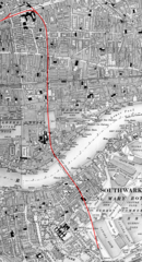
Map of the underground routing and approaches (highlighted in RED) to the Thames Tunnel, London UK
Resumen[editar]
| Descripción |
English: Map of the underground routing and approaches (highlighted in RED) to the Thames Tunnel, London UK, beginning at Whitechapel station and continuing south under Shadwell until reaching Wapping railway station, thence through the Thames Tunnel under the River Thames to Rotherhithe station and still underground passes beneath Southwark until it emerges from the ground near Deptford Road Station. |
| Fecha | 29 de julio de 2019 (fecha de carga) |
| Fuente | The uploader on Wikimedia Commons received this from the author/copyright holder via photosubmissions. |
| Autor | Route highlighting in RED by Jonathan Bluestone, derived from an Ordnance Survey map published ca. 1889 |
| Permiso (Reutilización de este archivo) |
Licencia[editar]
Derivative work:
| Este archivo está disponible bajo la licencia Creative Commons Dedicación de Dominio Público CC0 1.0 Universal. | |
| La persona que ha asociado una obra a este documento lo dedica al dominio público mediante la cesión mundial de sus derechos bajo la ley de derechos de autor y todos los derechos legales adyacentes propios de dicha, en el ámbito permitido por ley. Puedes copiar, modificar, distribuir y reproducir el trabajo, incluso con objetivos comerciales, sin pedir aprobación del autor.
|
Map:
This work is an Ordnance Survey map over 50 years old, which is covered by Crown Copyright which in this case expires 50 years after publication. Ordnance Survey does however ask that they be credited and that the date of publication be given.
Any ancillary rights gained through the creation of the electronic version are granted as freely usable under any circumstances.
|
Esta obra creada por el Gobierno del Reino Unido está en el dominio público porque se cumple una de las siguientes:
HMSO declaró que la expiración de los derechos de autor de la Corona se aplica en todo el mundo (ref: HMSO Email Reply)
|
 |
Historial del archivo
Haz clic sobre una fecha y hora para ver el archivo tal como apareció en ese momento.
| Fecha y hora | Miniatura | Dimensiones | Usuario | Comentario | |
|---|---|---|---|---|---|
| actual | 12:36 29 jul 2019 | | 2168 × 3998 (7,16 MB) | JGHowes (discusión | contribs.) | {{Information |Description={{en|1=Map of '''{{w|Thames Tunnel}}''', London UK. The underground portion is highlighted in <font color=red>'''''RED'''''</font color> beginning at {{w|Whitechapel station}} and continuing south under Shadwell until it reaches the Thames at {{w|Wapping railway station}}, where it goes under the Thames to {{w|Rotherhithe station}} and still underground passes beneath Southwark until it emerges from the ground close to Deptford Road Station.}} |Source={{author sourc... |
No puedes sobrescribir este archivo.
Usos del archivo
Las siguientes páginas usan este archivo:
Uso global del archivo
Las wikis siguientes utilizan este archivo:
- Uso en en.wikipedia.org
- Uso en eo.wikipedia.org
- Uso en es.wikipedia.org
- Uso en it.wikipedia.org