File:The Blue Ridge Mountains, the eastern boundary of the Shenandoah Valley (c1c4fe32-594c-4199-af81-494d9c6f1001).jpg
Jump to navigation
Jump to search

Size of this preview: 450 × 600 pixels. Other resolutions: 180 × 240 pixels | 360 × 480 pixels | 576 × 768 pixels | 768 × 1,024 pixels | 1,536 × 2,048 pixels | 3,120 × 4,160 pixels.
Original file (3,120 × 4,160 pixels, file size: 5.01 MB, MIME type: image/jpeg)
Captions
Captions
Add a one-line explanation of what this file represents

|
The categories of this image need checking. You can do so here.
|
.jpg&action=edit&withJS=MediaWiki:Catcheck.js)
Summary
[edit].jpg&action=edit§ion=1)
| English: Blue Ridge | ||||
|---|---|---|---|---|
| Photographer |
English: NPS Photo |
|||
| Title |
English: Blue Ridge |
|||
| Description |
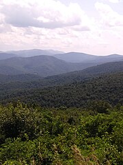
English: Tree covered ridges form the border of a mountain valley. The Blue Ridge Mountains, the eastern boundary of the Shenandoah Valley |
|||
| Depicted place |
English: Cedar Creek and Belle Grove National Historical Park, Virginia |
|||
| Date | Taken on 2 August 2022 | |||
| Accession number | ||||
| Source |
English: NPGallery |
|||
| Permission (Reusing this file) |
|
|||
| NPS Unit Code | CEBE | |||
| Album(s) | English: Scenic Cedar Creek & Belle Grove; Valley Geology |
|||
File history
Click on a date/time to view the file as it appeared at that time.
| Date/Time | Thumbnail | Dimensions | User | Comment | |
|---|---|---|---|---|---|
| current | 05:41, 24 June 2023 | | 3,120 × 4,160 (5.01 MB) | BMacZeroBot (talk | contribs) | Batch upload (Commons:Batch uploading/NPGallery) |
You cannot overwrite this file.
File usage on Commons
The following page uses this file:
.jpg)
.jpg&oldid=807070641)