File:The Dish Loop (42523518).jpeg
Jump to navigation
Jump to search

Size of this preview: 380 × 599 pixels. Other resolutions: 152 × 240 pixels | 304 × 480 pixels | 487 × 768 pixels | 649 × 1,024 pixels | 1,299 × 2,048 pixels.
Original file (1,299 × 2,048 pixels, file size: 594 KB, MIME type: image/jpeg)
Captions
Captions
Add a one-line explanation of what this file represents
Summary
[edit].jpeg&action=edit§ion=1)
| The Dish Loop | |
|---|---|
| Photographer | |
| Title |
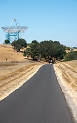
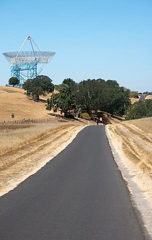
The Dish Loop |
| Description |
500px provided description: The first part of my hike was on the stanford dish trail, which is a nicely paved loop that rolls around the hills near the Stanford dish. This part of my hike was about 7 miles long. [#landscape] |
| Date | 27 July 2013, 16:48:02 (UTC) |
| Source | Imported from 500px (archived version) by the Archive Team. (detail page) |
| Permission (Reusing this file) |
This file is licensed under the Creative Commons Attribution 3.0 Unported license.
|
| Camera location | | View this and other nearby images on: OpenStreetMap |
|---|
.jpeg¶ms=037.405545_N_-122.175022_E_globe:Earth_type:camera__&language=en)
File history
Click on a date/time to view the file as it appeared at that time.
| Date/Time | Thumbnail | Dimensions | User | Comment | |
|---|---|---|---|---|---|
| current | 21:45, 4 August 2018 | | 1,299 × 2,048 (594 KB) | DarwIn (talk | contribs) | Photo The Dish Loop imported from 500px with import-500px |
You cannot overwrite this file.
File usage on Commons
The following page uses this file:
.jpeg)
.jpeg&oldid=799719832)