File:The first addition to Carlin Springs, Alexandria Co., Va. LOC gm70000115.jpg
Jump to navigation
Jump to search

Size of this preview: 800 × 546 pixels. Other resolutions: 320 × 219 pixels | 640 × 437 pixels | 1,024 × 699 pixels | 1,280 × 874 pixels | 2,560 × 1,748 pixels | 11,018 × 7,525 pixels.
Original file (11,018 × 7,525 pixels, file size: 7.14 MB, MIME type: image/jpeg)
Captions
Captions
Add a one-line explanation of what this file represents
Summary
[edit]| Warning | The original file is very high-resolution. It might not load properly or could cause your browser to freeze when opened at full size. |
|---|
| Description |
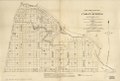
English: Scale ca. 1:1,650. Cadastral map showing block and lot numbers and dimensions. "The Norris Peters Co., photo-litho., Washington, D.C." Available also through the Library of Congress Web site as a raster image. 2 copies. Copy 2 is negative photocopy. DCP AACR2 |
||
| Title | The first addition to Carlin Springs, Alexandria Co., Va. | ||
| Shelf ID | G3884.C23G46 1890 .H6 | ||
| Date | |||
| Source | https://www.loc.gov/item/gm70000115/ | ||
| Author | Howell & Greenough; Carlin Springs Co-Operative Association; Curtis & Burdett; Norris Peters Co. | ||
| Permission (Reusing this file) |
|
||
| Other versions |
|
||
| Location | Arlington County · Arlington · Virginia · Carlin Springs (Arlington) · United States · Carlin Springs | ||
| Part of | American Memory · Cities And Towns · Catalog · Geography And Map Division | ||
| Subject | Arlington County · Carlin Springs (Arlington, Va.) · Virginia · Carlin Springs (Arlington) · United States · Maps · Real Property |

Licensing
[edit]
|
This is a faithful photographic reproduction of a two-dimensional, public domain work of art. The work of art itself is in the public domain for the following reason:
The official position taken by the Wikimedia Foundation is that "faithful reproductions of two-dimensional public domain works of art are public domain".
This photographic reproduction is therefore also considered to be in the public domain in the United States. In other jurisdictions, re-use of this content may be restricted; see Reuse of PD-Art photographs for details. | ||||
File history
Click on a date/time to view the file as it appeared at that time.
| Date/Time | Thumbnail | Dimensions | User | Comment | |
|---|---|---|---|---|---|
| current | 12:58, 13 June 2018 | | 11,018 × 7,525 (7.14 MB) | Fæ (talk | contribs) | LOC Maps https://www.loc.gov/item/gm70000115/ #14157 |
You cannot overwrite this file.
File usage on Commons
The following page uses this file: