File:The siege of Vicksburg, its approaches by Yazoo Pass and other routes LOC 99447423.jpg
Jump to navigation
Jump to search

Size of this preview: 403 × 600 pixels. Other resolutions: 161 × 240 pixels | 322 × 480 pixels | 516 × 768 pixels | 688 × 1,024 pixels | 1,376 × 2,048 pixels | 3,864 × 5,752 pixels.
Original file (3,864 × 5,752 pixels, file size: 3.29 MB, MIME type: image/jpeg)
Captions
Captions
Add a one-line explanation of what this file represents
Summary
[edit]| Description |
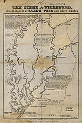
English: Scale not given. LC Civil War Maps (2nd ed.), 280 "Entered according to the Act of Congress, in the year 1863, by S. H. Goetzel & Co., in the Clerk's Office of the District Court of Alabama, for the Confederate States of America." Gives towns, Fort Pemberton, railroads, drainage, and the location of "Gen. Grant's Army 75000" opposite Vicksburg. Brief notes describe the "land lying between the Mississippi and Yazoo rivers" and the first and second "inland expedition[s] of the enemy." Description derived from published bibliography. LC copy 1 inscribed at top: Dora Miller May 26th 1865 Available also through the Library of Congress web site as raster image. |
||
| Title | The siege of Vicksburg, its approaches by Yazoo Pass and other routes | ||
| Shelf ID | G3984.V8S5 1863 .H3 | ||
| Date | |||
| Source | https://www.loc.gov/item/99447423/ | ||
| Author | Hardee, T. S. | ||
| Permission (Reusing this file) |
|
||
| Other versions |
|
||
| Location | United States · Mississippi · Vicksburg | ||
| Part of | Military Battles And Campaigns · American Memory · Civil War Maps · Catalog · Geography And Map Division | ||
| Subject | United States · Mississippi · Siege · Vicksburg (Miss.) · Maps · Vicksburg · History |


Licensing
[edit]
|
This is a faithful photographic reproduction of a two-dimensional, public domain work of art. The work of art itself is in the public domain for the following reason:
The official position taken by the Wikimedia Foundation is that "faithful reproductions of two-dimensional public domain works of art are public domain".
This photographic reproduction is therefore also considered to be in the public domain in the United States. In other jurisdictions, re-use of this content may be restricted; see Reuse of PD-Art photographs for details. | ||||
File history
Click on a date/time to view the file as it appeared at that time.
| Date/Time | Thumbnail | Dimensions | User | Comment | |
|---|---|---|---|---|---|
| current | 10:14, 25 May 2018 | | 3,864 × 5,752 (3.29 MB) | Fæ (talk | contribs) | LOC Maps https://www.loc.gov/item/99447423/ #14841 |
You cannot overwrite this file.
File usage on Commons
The following page uses this file: