File:Tibetan empire greatest extent 780s-790s CE.png
跳去導覽
跳去搵嘢

預覽大細:790 × 600 像素。 第啲解像度:316 × 240 像素 | 632 × 480 像素 | 1,011 × 768 像素 | 1,280 × 972 像素 | 1,792 × 1,361 像素。
原本檔案 (1,792 × 1,361 像素,檔案大細:4.55 MB ,MIME類型:image/png)
Captions
Captions
Add a one-line explanation of what this file represents
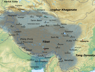
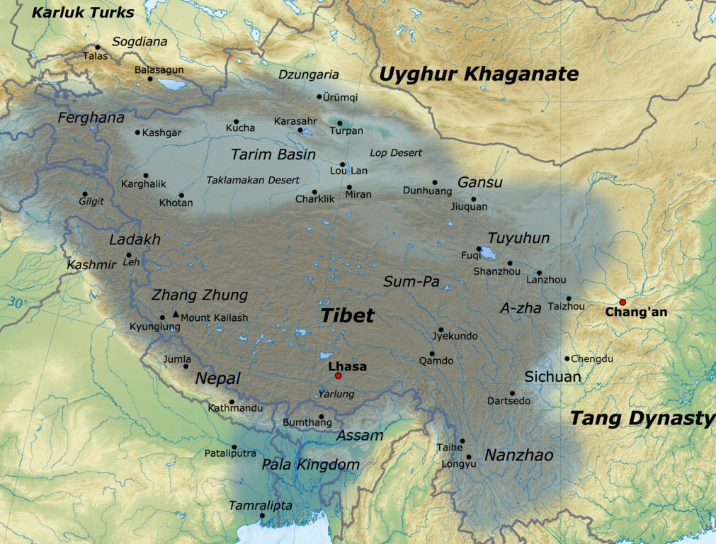
Map of the Tibetan Empire at its greatest extent between the 780s and the 790s CE
摘要[編輯]

|
This historical map image could be recreated using vector graphics as an SVG file. This has several advantages; see Commons:Media for cleanup for more information. If an SVG form of this image is already available, please upload it. After uploading an SVG, replace this template with {{vector version available|new image name.svg}}.
|
| 描述 |
English: Map of the Tibetan Empire at its greatest extent between the 780s and the 790s CE
sources:
|
| 日期 | |
| 來源 | 自己作品 |
| 作者 | Javierfv1212 |
協議[編輯]
我,呢份作品嘅作者,決定用以下許可發佈呢件作品:
Ĉi tiu dosiero estas disponebla laŭ la permesilo Krea Komunaĵo Atribuite 3.0 Neadaptita.
- 你可以:
- 去分享 – 複製、發佈同傳播呢個作品
- 再改 – 創作演繹作品
- 要遵照下面嘅條件:
- 署名 – 你一定要畀合適嘅表彰、畀返指向呢個授權條款嘅連結,同埋寫明有無改過嚟。你可以用任何合理方式去做,但唔可以用任何方式暗示授權人認可咗你或者你嘅使用方式。
檔案歷史
撳個日期/時間去睇響嗰個時間出現過嘅檔案。
| 日期/時間 | 縮圖 | 尺寸 | 用戶 | 註解 | |
|---|---|---|---|---|---|
| 現時 | 2021年1月16號 (六) 16:11 | | 1,792 × 1,361(4.55 MB) | Liandrei(傾偈 | 貢獻) | Cropped black border |
| 2011年3月29號 (二) 16:00 |  | 1,800 × 1,361(4.56 MB) | Javierfv1212(傾偈 | 貢獻) | {{Information |Description ={{en|1=Map of the Tibetan empire at it's Greatest extent between the 780s and the 790s CE sources: http://academic.reed.edu/anthro/364/maps.html http://unitednations4freetibet.com/unfft/wp-content/uploads/2010/11/The-Nation |
你無得衾咗個檔案。
檔案用途
以下嘅5版用到呢個檔:
全域檔案使用情況
下面嘅維基都用緊呢個檔案:
- af.wikipedia.org嘅使用情況
- ar.wikipedia.org嘅使用情況
- azb.wikipedia.org嘅使用情況
- az.wikipedia.org嘅使用情況
- ba.wikipedia.org嘅使用情況
- bg.wikipedia.org嘅使用情況
- bn.wikipedia.org嘅使用情況
- bo.wikipedia.org嘅使用情況
- bs.wikipedia.org嘅使用情況
- ca.wikipedia.org嘅使用情況
- cs.wikipedia.org嘅使用情況
- da.wikipedia.org嘅使用情況
- de.wikipedia.org嘅使用情況
- en.wikipedia.org嘅使用情況
- es.wikipedia.org嘅使用情況
- eu.wikipedia.org嘅使用情況
- fa.wikipedia.org嘅使用情況
- fi.wikipedia.org嘅使用情況
- fr.wikipedia.org嘅使用情況
睇呢個檔案嘅更多全域使用情況。