File:Tidal Bore - geograph.org.uk - 324581.jpg
跳去導覽
跳去搵嘢
冇更高解像度嘅圖像。
Tidal_Bore_-_geograph.org.uk_-_324581.jpg (640 × 461 像素,檔案大細:77 KB ,MIME類型:image/jpeg)
Captions
Captions
Add a one-line explanation of what this file represents
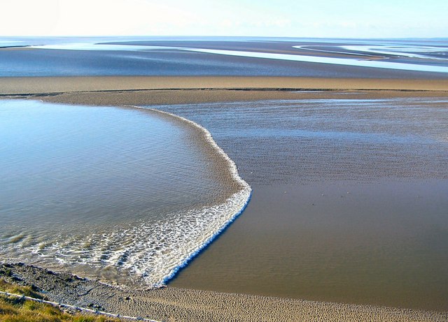
[[Arnside bore]] coming into the estuary of the River Kent in England
摘要[編輯]
| 描述 |
English: Tidal Bore The channels are constantly changing and consequently not shown on the OS map. Here the tidal bore is coming up a channel, one of several such channels in the estuary, on its way to Arnside some 8km away as the tide flows. It took 2 hours and 5 minutes to reach the viaduct at Arnside (shown in 324585) from this point. |
| 日期 | |
| 來源 | From geograph.org.uk |
| 作者 | Arnold Price |
| 姓名標示 (required by the license) | Arnold Price / Tidal Bore / |
| Object location | | View this and other nearby images on: OpenStreetMap |
|---|
_heading:202.00&language=yue)
協議[編輯]

|
This image was taken from the Geograph project collection. See this photograph's page on the Geograph website for the photographer's contact details. The copyright on this image is owned by Arnold Price and is licensed for reuse under the Creative Commons Attribution-ShareAlike 2.0 license.
|
This file is licensed under the Creative Commons Attribution-Share Alike 2.0 Generic license.
姓名標示: Arnold Price
- 你可以:
- 去分享 – 複製、發佈同傳播呢個作品
- 再改 – 創作演繹作品
- 要遵照下面嘅條件:
- 署名 – 你一定要畀合適嘅表彰、畀返指向呢個授權條款嘅連結,同埋寫明有無改過嚟。你可以用任何合理方式去做,但唔可以用任何方式暗示授權人認可咗你或者你嘅使用方式。
- 相同方式分享 – 如果你用任何方式改過呢個作品,你必須要用返原本或者相似嘅條款發佈。
檔案歷史
撳個日期/時間去睇響嗰個時間出現過嘅檔案。
| 日期/時間 | 縮圖 | 尺寸 | 用戶 | 註解 | |
|---|---|---|---|---|---|
| 現時 | 2010年12月30號 (四) 19:45 | | 640 × 461(77 KB) | GeographBot(傾偈 | 貢獻) | == {{int:filedesc}} == {{Information |description={{en|1=Tidal Bore The channels are constantly changing and consequently not shown on the OS map. Here the tidal bore is coming up a channel, one of several such channels in the estuary, on its way to Arnsi |
你無得衾咗個檔案。
檔案用途
無頁面用到呢個檔案。
全域檔案使用情況
下面嘅維基都用緊呢個檔案:
- ar.wikipedia.org嘅使用情況
- bn.wikipedia.org嘅使用情況
- en.wikipedia.org嘅使用情況
- es.wikipedia.org嘅使用情況
- fa.wikipedia.org嘅使用情況
- fr.wikipedia.org嘅使用情況
- fr.wikiversity.org嘅使用情況
- ga.wikipedia.org嘅使用情況
- he.wikipedia.org嘅使用情況
- ms.wikipedia.org嘅使用情況
- oc.wikipedia.org嘅使用情況
- ro.wikipedia.org嘅使用情況
- sl.wikipedia.org嘅使用情況
- tr.wikipedia.org嘅使用情況
- uk.wikipedia.org嘅使用情況
- zh-yue.wikipedia.org嘅使用情況