File:Tilisunahütte Panorama.jpg
Μετάβαση στην πλοήγηση
Πήδηση στην αναζήτηση
Μέγεθος αυτής της προεπισκόπησης: 800 × 211 εικονοστοιχεία . Άλλες αναλύσεις: 320 × 84 εικονοστοιχεία | 640 × 169 εικονοστοιχεία | 1.024 × 270 εικονοστοιχεία | 1.280 × 337 εικονοστοιχεία | 6.711 × 1.768 εικονοστοιχεία.
Πρωτότυπο αρχείο (6.711 × 1.768 εικονοστοιχεία, μέγεθος αρχείου: 8,68 MB, τύπος MIME: image/jpeg)
Λεζάντες
Λεζάντες
Δεν ορίστηκε λεζάντα
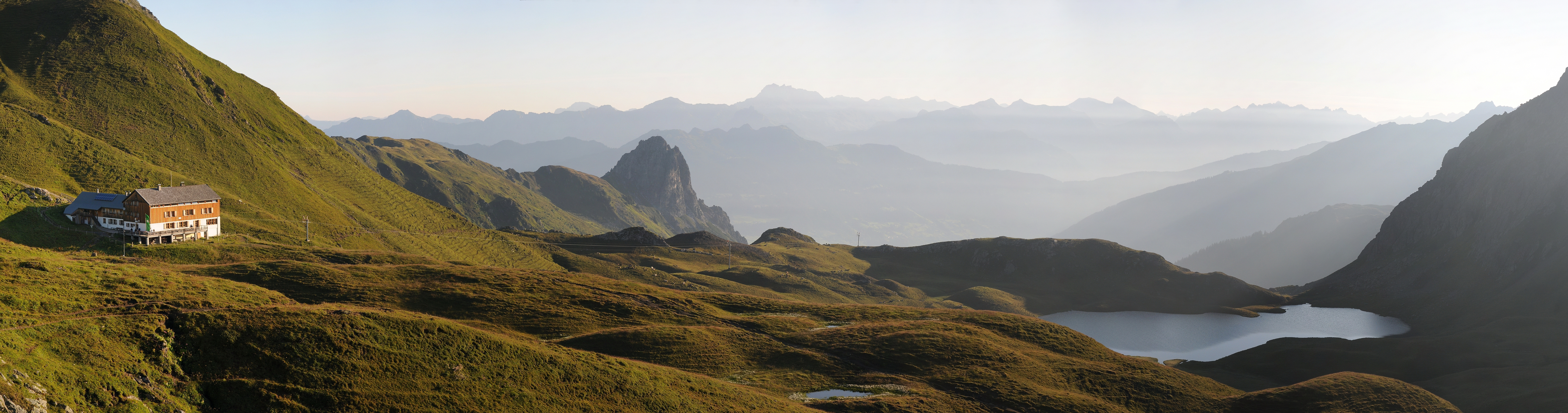
Panoramic picture of Rätikon mountain range in Austria, with Austrian Alpine Club hut Tilisunahütte on the left and Tilisunasee lake on the right.
| Περιγραφή |
Čeština: Panorama z pohoří Rätikon v Rakousko, nedaleko hranic se Švýcarskem. Vlevo chata Tilisunahütte Rakouského alpského spolku ležící ve výšce 2211 m n. m.
Deutsch: Panorama um 07:10 Uhr nach dem Sonnenaufgang über dem Tilisunasee. Links die Tilisunahütte. Sie ist eine Berghütte des Österreichischen Alpenvereins (OeAV), Sektion Vorarlberg, in der Region Montafon, Bundesland Vorarlberg / Österreich. Sie liegt südlich von Tschagguns auf einer Höhe von 2'211 m ü. M. nördlich der Sulzfluh, in aussichtsreicher Lage mit Blick ins Montafon. Der Berganstieg links führt auf das Tilisuna-Schwarzhorn 2.460m und in der Bildmitte die Tschaggunser Mittagsspitze.
English: Panoramic picture of Rätikon mountain range in Austria, near the border of Switzerland, with Austrian Alpine Club hut Tilisunahütte on the left. Hut is located south of village Tschagguns in elevation of 2,211 m.
Русский: Окрестности Чаггунс, Форарльберг, Австрия.
Italiano: Foto panoramica della catena del Rätikon in Austria vicino al confine svizzero. Sulla sinistra il rifugio Tilisunahütte dell'Österreichischer Alpenverein.
|
||
| Ημερομηνία | |||
| Πηγή | Έργο αυτού που το ανεβάζει | ||
| Δημιουργός | böhringer friedrich | ||
| Άδεια (Επαναχρησιμοποίηση αυτού του αρχείου) |
Εγώ, ο κάτοχος των πνευματικών δικαιωμάτων αυτού του έργου, το δημοσιεύω δια του παρόντος υπό την εξής άδεια χρήσης: Το αρχείο διανέμεται υπό την άδεια Creative Commons Αναφορά προέλευσης-Παρόμοια διανομή 2.5 Γενική
|

| Camera location | | View this and other nearby images on: OpenStreetMap |
|---|
This Photo was taken by Böhringer Friedrich.
|
Feel free to use my photos, but please mention me as the author and if you want send me a message. or (rufre@lenz-nenning.at) |
| Annotations | This image is annotated: View the annotations at Commons |
Assessment
[επεξεργασία]
|

This image was selected as picture of the day on Wikimedia Commons for 1 August 2012. It was captioned as follows: English: Panoramic picture of Rätikon mountain range in Austria, near the border of Switzerland, with Austrian Alpine Club hut Tilisunahütte on the left. Other languages:
English: Panoramic picture of Rätikon mountain range in Austria, near the border of Switzerland, with Austrian Alpine Club hut Tilisunahütte on the left. Italiano: Foto panoramica della catena del Rätikon in Austria vicino al confine svizzero. Sulla sinistra il rifugio Tilisunahütte dell'Österreichischer Alpenverein. Magyar: A Rätikon-hegység panorámaképe Ausztriában, közel a svájci határhoz. Bal oldalon a Tilisunahütte alpesi menedékház. Nederlands: Panoramische foto van het bergmassief Rätikon in Oostenrijk nabij de grens met Zwitserland met links de Tilisunahütte van de Österreichischer Alpenverein. Português: Imagem panorâmica da cordilheira Rätikon, na Áustria, próximo à fronteira com a Suíça. Русский: Панорама хребта Ретикон в Австрии. Слева горная хижина Тилисуна, принадлежащая Австрийскому Горному Клубу ქართული: რეტიკონის ქედის პანორამა ავსტრიაში, შვეიცარიის საზღვრის სიახლოვეს. მარცხნივ ავსტრიული სამთო კლუბის ქოხი. 中文: 雷蒂孔山在奥地利的全景图,靠近与瑞士的边境,左边有一座奥地利阿尔卑斯山俱乐部的小屋。 |
Αυτή η εικόνα έχει κριθεί σύμφωνα με τις οδηγίες για Ποιοτικές εικόνες και τεκμαίρεται ως Ποιοτική εικόνα.
|
Ιστορικό αρχείου
Πατήστε σε μια ημερομηνία/ώρα για να δείτε το αρχείο όπως εμφανιζόταν εκείνη την χρονική στιγμή.
| Ημερομηνία/Ώρα | Μικρογραφία | Διαστάσεις | Χρήστης | Σχόλιο | |
|---|---|---|---|---|---|
| τρέχον | 21:11, 2 Αυγούστου 2011 | 6.711 × 1.768 (8,68 MB) | Böhringer (συζήτηση | Συνεισφορά) | {{Information |Description= {{de|Panorama um 07:10 Uhr nach dem Sonnenaufgang über dem Tilisunasee. Links die Tilisunahütte. Sie ist eine Berghütte des Österreichischen Alpenvereins (OeAV), Sektion Vorarlberg, in der Region [[:d |
Δεν μπορείτε να αντικαταστήσετε αυτό το αρχείο.
Χρήση αρχείου
Οι ακόλουθες 61 σελίδες χρησιμοποιούν προς αυτό το αρχείο:
- Exzellente Bilder aus Vorarlberg
- User:Böhringer
- User:Böhringer/Archive 4
- User:Chriswaterguy/Picture of the Year/2011 - larger
- User:Julian Herzog/Favorites
- User:Sadko
- User:Sadko/Template:UP
- User:Samsara/POTY 2011 overview
- User:Stefahn
- User:Ö/Best/2011
- Commons:Featured picture candidates/File:Tilisunahütte Panorama.jpg
- Commons:Featured picture candidates/Log/August 2011
- Commons:Featured pictures/Places/Natural/Austria
- Commons:Featured pictures/Places/Panoramas
- Commons:Featured pictures/chronological/2011-B
- Commons:Photo challenge/2015 - May - Panoramas
- Commons:Picture of the Year/2011
- Commons:Picture of the Year/2011/Finalists
- Commons:Picture of the Year/2011/Finalists/Tilisunahütte Panorama.jpg
- Commons:Picture of the Year/2011/Galleries/2011-B
- Commons:Picture of the Year/2011/Galleries/ALL
- Commons:Picture of the Year/2011/Galleries/AUG
- Commons:Picture of the Year/2011/Galleries/B
- Commons:Picture of the Year/2011/Galleries/B/table
- Commons:Picture of the Year/2011/Galleries/Index/11
- Commons:Picture of the Year/2011/Galleries/Index/8
- Commons:Picture of the Year/2011/Galleries/Index/ALL
- Commons:Picture of the Year/2011/Galleries/Index/Panoramic nature views
- Commons:Picture of the Year/2011/Galleries/Panoramic nature views
- Commons:Picture of the Year/2011/Galleries/Panoramic nature views/Large
- Commons:Picture of the Year/2011/Galleries/Panoramic nature views/Small
- Commons:Picture of the Year/2011/Galleries/table
- Commons:Picture of the Year/2011/R1/Tilisunahütte Panorama.jpg
- Commons:Picture of the Year/2011/Results
- Commons:Picture of the Year/2011/Results/R1/ALL/table
- Commons:Picture of the Year/2011/Results/R1/Category
- Commons:Picture of the Year/2011/Results/R1/Checking
- Commons:Picture of the Year/2011/Results/R1/Finalists
- Commons:Picture of the Year/2011/Results/R1/Finalists/table
- Commons:Picture of the Year/2011/Results/R1/Panoramic nature views
- Commons:Picture of the Year/2011/Results/R1/Panoramic nature views/table
- Commons:Picture of the Year/2011/Results/R2
- Commons:Picture of the Year/2011/Results/R2/table
- Commons:Picture of the Year/2011/Translations
- Commons:Quality images/Subject/Places/Mixed/Panorama/Archive 2008 to 2015
- Commons:Quality images candidates/Archives August 2011
- Commons:Vuoden kuva/2011/Tulokset
- Commons:ภาพแห่งปี/2011
- Commons talk:Photo challenge/themes/Archive
- Commons talk:Picture of the Year/2011/Results/R1
- Commons talk:Picture of the Year/2011/Results/R1/ALL/table
- Template:Potd/2012-08
- Template:Potd/2012-08-01
- Template:Potd/2012-08-01 (en)
- Template:Potd/2012-08-01 (hu)
- Template:Potd/2012-08-01 (it)
- Template:Potd/2012-08-01 (ka)
- Template:Potd/2012-08-01 (nl)
- Template:Potd/2012-08-01 (pt)
- Template:Potd/2012-08-01 (zh-hans)
- Template:Potd/2012-08 (zh-hans)
Καθολική χρήση αρχείου
Τα ακόλουθα άλλα wiki χρησιμοποιούν αυτό το αρχείο:
- Χρήση σε be-tarask.wikipedia.org
- Χρήση σε bn.wikipedia.org
- Χρήση σε crh.wikipedia.org
- Χρήση σε cv.wikipedia.org
- Χρήση σε de.wikipedia.org
- Χρήση σε en.wikipedia.org
- Χρήση σε et.wikipedia.org
- Χρήση σε hu.wikipedia.org
- Χρήση σε it.wikipedia.org
- Χρήση σε ka.wikipedia.org
- Χρήση σε ko.wikipedia.org
- Χρήση σε krc.wikipedia.org
- Χρήση σε lbe.wikipedia.org
- Χρήση σε os.wikipedia.org
- Χρήση σε ru.wikipedia.org
- Χρήση σε ru.wikinews.org
- Χρήση σε sah.wikipedia.org
- Χρήση σε sr.wikipedia.org
- Χρήση σε uk.wikipedia.org
- Χρήση σε vi.wikipedia.org
- Χρήση σε xal.wikipedia.org
- Χρήση σε zh.wikipedia.org