File:Timor island.jpg

Арыгінальны файл (640 × 640 піксэляў, памер файла: 149 кб, тып MIME: image/jpeg)
Подпісы
Подпісы
Апісаньне[рэдагаваць]
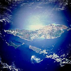
- Description: STS033-082-071 Timor Island, Indonesia November 1989.
Timor Island, one of the larger islands of the Lesser Sunda Islands, is located between the Savu Sea to the northwest and the Timor Sea to the southeast. The western half of the island, under Dutch control until 1949, and the eastern half, a Portuguese province until 1975, are now united as a province of Indonesia. Timor Island is approximately 300 miles (480 kilometers) long and 10 to 65 miles (16 to 105 kilometers) wide. Timor and the north-northwest arc of islands around the eastern end of the Banda Sea, all volcanic in origin, are in an unstable region of the world because of the intersection of three major tectonic plates northeast near Irian Jaya, Indonesia. Although it is located in the tropics, Timor Island has a definite dry season during the winter. Large forested volcanic mountains exist; however, much of the landscape lacks dense stands of tropical forest or jungle. Major cash crops include coffee, sandalwood, and copra.
This almost totally cloud free, photo of the island of Timor, Indonesia (9.0S, 125.0E) illustrates the volcanic origin of the over 1500 islands of Indonesia. Close examination of the photo reveals several eroded volcanoes on the Island of Timor and several of the adjacent islands. The linear alignment of the volcanoes, as seen from space, indicates the edges of the tectonic plates of the Earth's crust where volcanic activity is most common.
- Photo #: STS033-82-71
- Date: Nov. 1989
- Source: eol.jsc.nasa.gov
Гэтая выява ці відэа было занесенае ў каталёг аднаго з цэнтраў Нацыянальнай управы аэранаўтыкі і космасу (НАСА) Злучаных Штатаў Амэрыкіпад ідэнтыфікатарам: STS033-082-071. Гэтае паведамленьне не адлюстроўвае ані стан аўтарскага права, ані крыніцу дадзенага твору. Мусіць быць даданае слушнае пазначэньне ліцэнзіі. Глядзіце ўмовы ліцэнзаваньня для болей падрабязных зьвестак. Іншыя мовы:
|
Ліцэнзія[рэдагаваць]
| Гэты файл знаходзіцца ў грамадзкім набытку, бо створаны NASA. Аўтарская палітыка NASA сьведчыць, што «матэрыялы NASA не абараняюцца законам аб аўтарскім праве, пакуль не паведамляецца адваротнае». (NASA тэкст ці Палітыка выкарыстаньня выяваў JPL). | ||
 |
Заўвагі:
|
Гісторыя файла
Націсьніце на дату/час, каб паглядзець, як тады выглядаў файл.
| Дата і час | Мініятура | Памеры | Удзельнік | Камэнтар | |
|---|---|---|---|---|---|
| цяперашняя | 02:27, 19 кастрычніка 2005 | | 640 × 640 (149 кб) | Lofor (Абмеркаваньне | унёсак) | http://en.wikipedia.org/wiki/Image:Timor_island.jpg |
Вы ня можаце перазапісаць гэты файл.
Выкарыстаньне файла
Ніводная старонка не выкарыстоўвае гэты файл.
Глябальнае выкарыстаньне файла
Гэты файл выкарыстоўваецца ў наступных вікі:
- Выкарыстаньне ў be-tarask.wikipedia.org
- Выкарыстаньне ў de.wikinews.org
- Выкарыстаньне ў en.wikinews.org
- Выкарыстаньне ў no.wikipedia.org
- Выкарыстаньне ў or.wikipedia.org