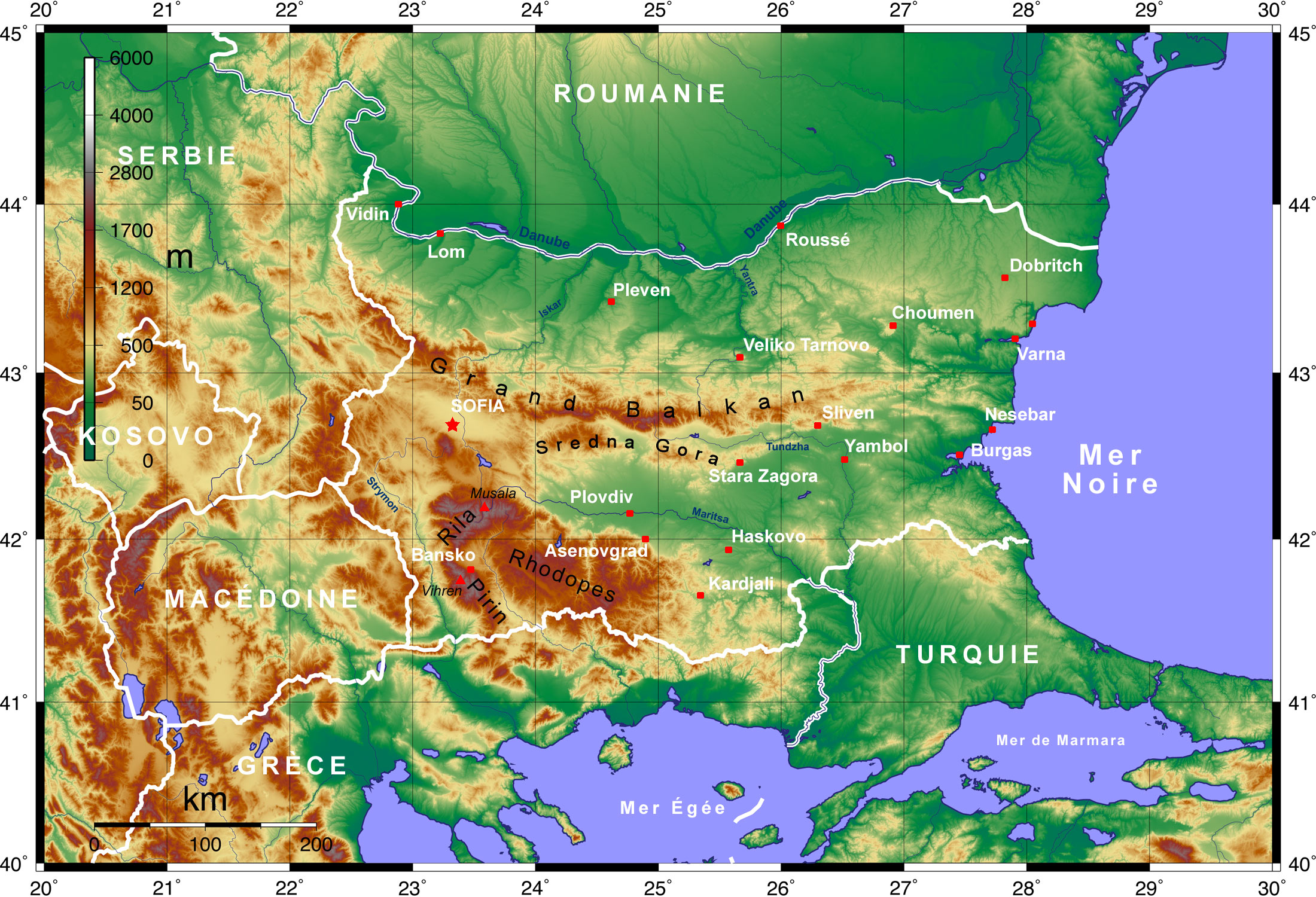
File:Topographic Map of Bulgaria Francais.jpg
(Redirected from File:Topographic Map of Bulgaria Francais.png)
Size of this preview: 800 × 545 pixels. Other resolutions: 320 × 218 pixels | 640 × 436 pixels | 1,024 × 698 pixels | 1,280 × 873 pixels | 2,200 × 1,500 pixels.
Original file (2,200 × 1,500 pixels, file size: 778 KB, MIME type: image/jpeg)
Captions
Captions
Add a one-line explanation of what this file represents
| Description |
English: Topographic map of Bulgaria with English labels, created with GMT and elevation data from the SRTM Deutsch: Topographische Karte Bulgariens mit Beschriftung in englischer Sprache; erstellt mit den GMT unter Verwendung der SRTM-3-Höhendaten |
| Date | (UTC) |
| Source | |
| Author |
|
| This is a retouched picture, which means that it has been digitally altered from its original version. Modifications: translation in french. The original can be viewed here: Topographic Map of Bulgaria English.png:
|
I, the copyright holder of this work, hereby publish it under the following license:
This file is licensed under the Creative Commons Attribution 3.0 Unported license.
- You are free:
- to share – to copy, distribute and transmit the work
- to remix – to adapt the work
- Under the following conditions:
- attribution – You must give appropriate credit, provide a link to the license, and indicate if changes were made. You may do so in any reasonable manner, but not in any way that suggests the licensor endorses you or your use.
Original upload log[edit]
This image is a derivative work of the following images:
- File:Topographic_Map_of_Bulgaria_English.png licensed with Cc-by-3.0
- 2008-06-02T20:42:57Z Equestenebrarum 2200x1500 (4424838 Bytes) {{Information |Description={{en|1=Topographic map of Bulgaria with English labels, created with GMT and elevation data from the SRTM}} {{de|1=Topographische Karte Bulgariens mit Beschriftung in englischer Sprache; erstellt mi
Uploaded with derivativeFX
File history
Click on a date/time to view the file as it appeared at that time.
| Date/Time | Thumbnail | Dimensions | User | Comment | |
|---|---|---|---|---|---|
| current | 17:28, 5 February 2010 | | 2,200 × 1,500 (778 KB) | Pline (talk | contribs) | file error |
| 17:26, 5 February 2010 |  | 2,200 × 1,500 (4.1 MB) | Pline (talk | contribs) | {{Information |Description={{en|1=Topographic map of Bulgaria with English labels, created with GMT and elevation data from the SRTM}} {{de|1=Topographische Karte Bulgariens mit Beschriftung in englischer Sprache; erstellt mit den GMT unter Verwendung der |
You cannot overwrite this file.
File usage on Commons
The following page uses this file:
- File:Topographic Map of Bulgaria Francais.png (file redirect)
File usage on other wikis
The following other wikis use this file:
- Usage on fr.wikipedia.org