File:Topography, Mindanao - UNESCO - PHOTO0000005197 0000.tiff
Jump to navigation
Jump to search
Size of this JPG preview of this TIF file: 787 × 600 pixels. Other resolutions: 315 × 240 pixels | 630 × 480 pixels | 1,008 × 768 pixels | 1,280 × 976 pixels | 2,560 × 1,951 pixels | 5,759 × 4,389 pixels.
Original file (5,759 × 4,389 pixels, file size: 72.78 MB, MIME type: image/tiff)
Captions
Captions
Add a one-line explanation of what this file represents
Summary[edit]
| Photographer |
|
||||||||||||||||
| Description |
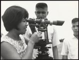
English: A woman is looking into a topographic equipment outdoors while two men are observing the process. |
||||||||||||||||
| Depicted place | Mindanao, Philippines (Q928) | ||||||||||||||||
| Keywords | Topography, Development programmes, Agricultural development, Land reform, Measuring instruments, Measurement, | ||||||||||||||||
| Date | 1969 | ||||||||||||||||
| Accession number |
PHOTO0000005197 |
||||||||||||||||
| Inscriptions |
English: Mindanao Institute of Technology. The Government of the Philippines, with the assistance of the United Nations Development Programme for which UNESCO is acting as executing agency, has undertaken a project to strengthen the programmes of applied research and teaching in agriculture at Mindanao Institute of Technology. This project will contribute significantly towards fulfilling the need for trained personnel in the government-sponsored Land Reform and Rural Development Programme. Students learn the principles of surveying as part of their programme of studies. Français : Institut de Technologie de Mindanao. Le Gouvernement des Philippines et le Programme des Nations Unies pour la Développement - dont l'UNESCO est l'agent d'exécution - ont conclu un accord en vue de développer le programme d'enseignement et de recherche appliquée dans la domaine de l'agriculture à l'Institut de Technologie de Mindanao. Ce projet contribuera à former le personnel qui sera chargé d'appliquer le programme gouvernemental de réforme agraire et de développement rural. Les levés topographiques font partie du programme d'enseignement. |
||||||||||||||||
| Archival code | 35.595 | ||||||||||||||||
| Source |
|
||||||||||||||||
| Permission (Reusing this file) |
This file is licensed under the Creative Commons Attribution-ShareAlike 3.0 IGO license. Attribution: UNESCO / Dominique Roger
|
||||||||||||||||
| Other versions |
|
||||||||||||||||

File history
Click on a date/time to view the file as it appeared at that time.
| Date/Time | Thumbnail | Dimensions | User | Comment | |
|---|---|---|---|---|---|
| current | 12:37, 7 November 2020 |  | 5,759 × 4,389 (72.78 MB) | AliciaFagervingWMSE-bot (talk | contribs) | pattypan 20.04 |
You cannot overwrite this file.
File usage on Commons
The following 3 pages use this file: