File:Torii path with lantern at Fushimi Inari Taisha Shrine, Kyoto, Japan.jpg
Jump to navigation
Jump to search

Size of this preview: 800 × 533 pixels. Other resolutions: 320 × 213 pixels | 640 × 427 pixels | 1,024 × 683 pixels | 1,280 × 853 pixels | 2,560 × 1,707 pixels | 5,765 × 3,843 pixels.
Original file (5,765 × 3,843 pixels, file size: 8.71 MB, MIME type: image/jpeg)
Captions
Captions
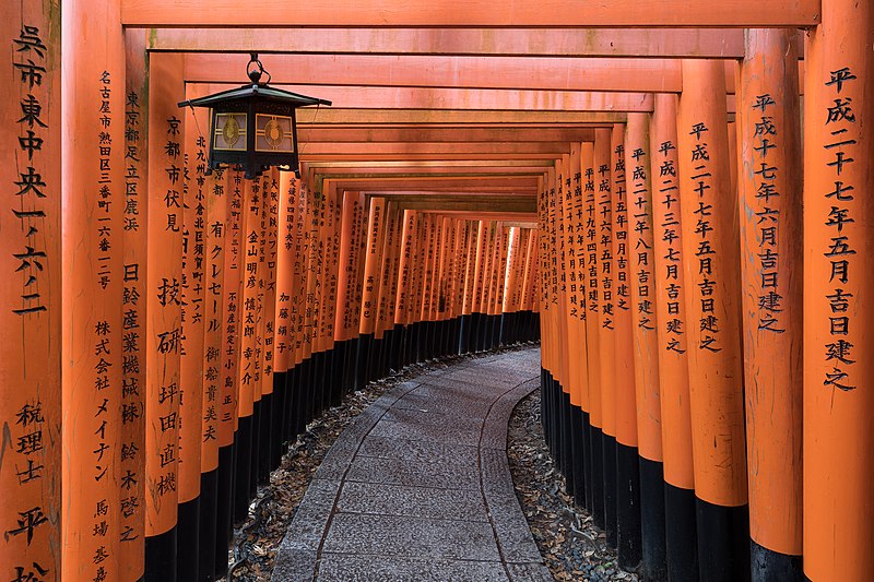
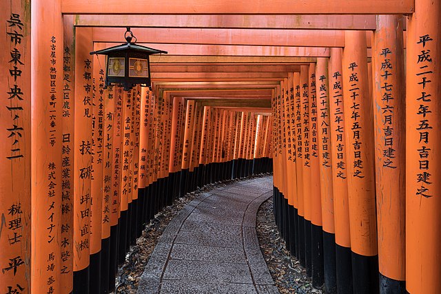
Torii path with lantern at Fushimi Inari Taisha Shrine, Kyoto, Japan
Summary
[edit]
| Description |
English: Torii path with a hanging lantern at Fushimi Inari Taisha Shrine Senbontorii, Kyoto, Japan.
Français : Couloir torii avec une lanterne suspendue au sanctuaire Senbontorii Fushimi Inari Taisha, Kyoto, Japon. |
| Date | |
| Source | Own work |
| Author | Basile Morin |
| Camera location | | View this and other nearby images on: OpenStreetMap |
|---|
|
Licensing
[edit]
I, the copyright holder of this work, hereby publish it under the following license:
This file is licensed under the Creative Commons Attribution-Share Alike 4.0 International license.
- You are free:
- to share – to copy, distribute and transmit the work
- to remix – to adapt the work
- Under the following conditions:
- attribution – You must give appropriate credit, provide a link to the license, and indicate if changes were made. You may do so in any reasonable manner, but not in any way that suggests the licensor endorses you or your use.
- share alike – If you remix, transform, or build upon the material, you must distribute your contributions under the same or compatible license as the original.
File history
Click on a date/time to view the file as it appeared at that time.
| Date/Time | Thumbnail | Dimensions | User | Comment | |
|---|---|---|---|---|---|
| current | 15:55, 4 August 2019 | | 5,765 × 3,843 (8.71 MB) | Basile Morin (talk | contribs) | User created page with UploadWizard |
You cannot overwrite this file.
File usage on Commons
The following 17 pages use this file:
- User:Basile Morin
- User:Dronebogus/More random images I find interesting or amusing
- User:Thi/Useful pictures
- User talk:Basile Morin/Archive 5
- User talk:Basile Morin/Archive 6 (Aug-Dec 2019)
- Commons:Featured picture candidates/File:Torii path with lantern at Fushimi Inari Taisha Shrine, Kyoto, Japan.jpg
- Commons:Featured picture candidates/Log/August 2019
- Commons:Featured pictures/Places/Architecture/Religious buildings
- Commons:Featured pictures/chronological/2019-B
- Commons:Picture of the Year/2019/Candidates
- Commons:Picture of the Year/2019/R1/Gallery/2019-B
- Commons:Picture of the Year/2019/R1/Gallery/ALL
- Commons:Picture of the Year/2019/R1/Gallery/M08
- Commons:Picture of the Year/2019/R1/Gallery/Religious Buildings
- Commons:Picture of the Year/2019/R1/v/Torii path with lantern at Fushimi Inari Taisha Shrine, Kyoto, Japan.jpg
- Commons:Quality images/Subject/Architecture/Religious/Other/Archive 2018 to 2019
- Commons:Quality images candidates/Archives August 07 2019
File usage on other wikis
The following other wikis use this file:
- Usage on az.wikipedia.org
- Usage on de.wikipedia.org
- Usage on en.wikipedia.org
- Star Fox (1993 video game)
- The Gates
- Fushimi Inari-taisha
- Portal:Japan
- Portal:Japan/Projects
- Talk:Fushimi Inari-taisha
- Wikipedia:Featured pictures/Places/Others
- Wikipedia:WikiProject Japan/Recognized content
- User talk:Basile Morin
- Wikipedia:WikiProject Japan/Recognized content list
- User:Basile Morin
- Portal:The arts/Recognized content
- Portal:Japan/Recognized content
- Portal:Architecture/Recognized content
- Wikipedia:Featured pictures thumbs/71
- User talk:MER-C/archives/57
- Wikipedia:Featured picture candidates/August-2021
- Wikipedia:Featured picture candidates/File:Torii path with lantern at Fushimi Inari Taisha Shrine, Kyoto, Japan.jpg
- Wikipedia:Picture of the day/March 2024
- Template:POTD/2024-03-15
- Wikipedia:Main Page history/2024 March 15
- Wikipedia:Main Page history/2024 March 15b
- Usage on es.wikipedia.org
- Usage on fi.wikipedia.org
- Usage on fr.wikipedia.org
- Usage on ja.wikipedia.org
- Usage on mg.wikipedia.org
- Usage on my.wikipedia.org
- Usage on ru.wikipedia.org
- Usage on sl.wikipedia.org
- Usage on sn.wikipedia.org
- Usage on ta.wikipedia.org
- Usage on tr.wikipedia.org