File:Trafalgar 1200hr-fr.svg
Jump to navigation
Jump to search

Size of this PNG preview of this SVG file: 635 × 600 pixels. Other resolutions: 254 × 240 pixels | 508 × 480 pixels | 813 × 768 pixels | 1,084 × 1,024 pixels | 2,168 × 2,048 pixels | 900 × 850 pixels.
Original file (SVG file, nominally 900 × 850 pixels, file size: 73 KB)
Captions
Captions
Add a one-line explanation of what this file represents
Summary
[edit]
| Description |
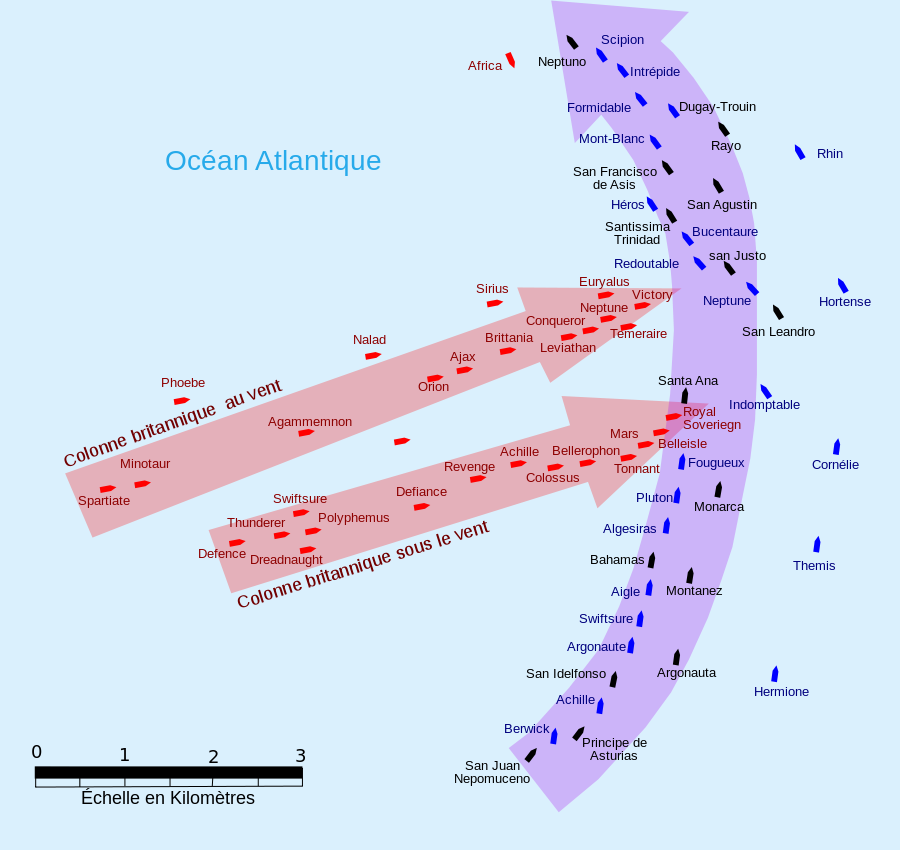
English: French version :This map of the Battle of Trafalgar shows the approximate position of the two fleets at 1200 hours during the battle as the Royal Sovereign was breaking into the Franco-Spanish line. North is to the top, and Cape Trafalgar is 10 miles to the northeast.
Français : Version française : Cette carte de la Bataille de Trafalgar montre les positions approximatives des deux flottes à 12 heures de la bataille lorsque la flotte royale aborde la ligne franco-espagnole. Le nord est en haut et le cap Trafalgar est à 10 miles au nord-est. |
| Date | |
| Source | own work made with Inkscape from Image:Trafalgar 1200hr.gif : This drawing is based on an illustration in issue number 84 of the Strategy & Tactics magazine The map was made by RJHall using the Campaign Cartographer drawing program, and the image was reduced in size 50% in Paint Shop Pro. Ship icons are not to scale. |
| Author | Pinpin |
| SVG development |
Licensing
[edit]
I, the copyright holder of this work, hereby publish it under the following licenses:

|
Permission is granted to copy, distribute and/or modify this document under the terms of the GNU Free Documentation License, Version 1.2 or any later version published by the Free Software Foundation; with no Invariant Sections, no Front-Cover Texts, and no Back-Cover Texts. A copy of the license is included in the section entitled GNU Free Documentation License. |
This file is licensed under the Creative Commons Attribution-Share Alike 3.0 Unported, 2.5 Generic, 2.0 Generic and 1.0 Generic license.
- You are free:
- to share – to copy, distribute and transmit the work
- to remix – to adapt the work
- Under the following conditions:
- attribution – You must give appropriate credit, provide a link to the license, and indicate if changes were made. You may do so in any reasonable manner, but not in any way that suggests the licensor endorses you or your use.
- share alike – If you remix, transform, or build upon the material, you must distribute your contributions under the same or compatible license as the original.
You may select the license of your choice.
File history
Click on a date/time to view the file as it appeared at that time.
| Date/Time | Thumbnail | Dimensions | User | Comment | |
|---|---|---|---|---|---|
| current | 06:35, 5 October 2007 | | 900 × 850 (73 KB) | Pinpin (talk | contribs) | |
| 20:10, 3 October 2007 |  | 900 × 850 (73 KB) | Pinpin (talk | contribs) | forget one boat | |
| 20:07, 3 October 2007 |  | 900 × 850 (72 KB) | Pinpin (talk | contribs) | == Description == {{Information |Description={{en|French version :This map of the '''Battle of Trafalgar''' shows the approximate position of the two fleets at 1200 hours during the battle as the Royal Sovereign was breaking into the Franco-Spanish li |
You cannot overwrite this file.
File usage on Commons
There are no pages that use this file.
File usage on other wikis
The following other wikis use this file:
- Usage on fr.wikipedia.org
- Bataille de Trafalgar
- England expects that every man will do his duty
- Achille (1803)
- Wikipédia:Atelier graphique/Images à améliorer/Archives/Septembre 2008
- HMS Agamemnon (1781)
- HMS Bellerophon (1786)
- HMS Temeraire (1798)
- Ordre de bataille de la bataille de Trafalgar
- Olivier Jourdan de La Passardière
- Projet:Maritime/Bistro du port/Décembre 2013
- Michel Chesneau