File:Trafalgar 1200hr.svg
ナビゲーションに移動
検索に移動

この SVG ファイルのこの PNG プレビューのサイズ: 606 × 599 ピクセル. その他の解像度: 243 × 240 ピクセル | 485 × 480 ピクセル | 776 × 768 ピクセル | 1,035 × 1,024 ピクセル | 2,070 × 2,048 ピクセル | 743 × 735 ピクセル。
元のファイル (SVG ファイル、743 × 735 ピクセル、ファイルサイズ: 77キロバイト)
キャプション
キャプション
このファイルの内容を1行で記述してください
概要[編集]
| 解説 |
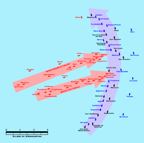
English: This map of the Battle of Trafalgar shows the approximate position of the two fleets at 1200 hours during the battle as the Royal Sovereign was breaking into the Franco-Spanish line. North is to the top, and Cape Trafalgar is 10 miles to the northeast. |
| 日付 | |
| 原典 | own work made with Inkscape from Image:Trafalgar 1200hr.gif : This drawing is based on an illustration in issue number 84 of the Strategy & Tactics magazine The map was made by RJHall using the Campaign Cartographer drawing program, and the image was reduced in size 50% in Paint Shop Pro. Ship icons are not to scale. |
| 作者 | Pinpin |
ライセンス[編集]
この作品の著作権者である私は、この作品を以下のライセンスで提供します。

|
この文書は、フリーソフトウェア財団発行のGNUフリー文書利用許諾書 (GNU Free Documentation License) 1.2またはそれ以降のバージョンの規約に基づき、複製や再配布、改変が許可されます。不可変更部分、表紙、背表紙はありません。このライセンスの複製は、GNUフリー文書利用許諾書という章に含まれています。 |
- あなたは以下の条件に従う場合に限り、自由に
- 共有 – 本作品を複製、頒布、展示、実演できます。
- 再構成 – 二次的著作物を作成できます。
- あなたの従うべき条件は以下の通りです。
- 表示 – あなたは適切なクレジットを表示し、ライセンスへのリンクを提供し、変更があったらその旨を示さなければなりません。これらは合理的であればどのような方法で行っても構いませんが、許諾者があなたやあなたの利用行為を支持していると示唆するような方法は除きます。
- 継承 – もしあなたがこの作品をリミックスしたり、改変したり、加工した場合には、あなたはあなたの貢献部分を元の作品とこれと同一または互換性があるライセンスの下に頒布しなければなりません。
あなたは上記のライセンスから、どれか一つ以上を選択できます。
ファイルの履歴
過去の版のファイルを表示するには、その版の日時をクリックしてください。
| 日付と時刻 | サムネイル | 寸法 | 利用者 | コメント | |
|---|---|---|---|---|---|
| 現在の版 | 2008年1月29日 (火) 03:45 | | 743 × 735 (77キロバイト) | Uhanu (トーク | 投稿記録) | I forgot the colour of Belleisle. |
| 2008年1月29日 (火) 03:43 |  | 743 × 735 (77キロバイト) | Uhanu (トーク | 投稿記録) | Correcting some names: Montañés , San Ildefonso, Agamemnon, Duguay-Trouin... and colour of Belleisle. | |
| 2007年12月14日 (金) 18:55 |  | 743 × 735 (77キロバイト) | Rama (トーク | 投稿記録) | Original SVG version at Image:Trafalgar 1200hr.gif * '''Description:''' This map of the '''Battle of Trafalgar''' shows the approximate position of the two fleets at 1200 hours during the battle as the Royal Sovereign was breaking into the Franc | |
| 2007年10月3日 (水) 20:11 |  | 900 × 850 (73キロバイト) | Pinpin (トーク | 投稿記録) | I forget one boat | |
| 2007年10月3日 (水) 20:04 |  | 900 × 850 (72キロバイト) | Pinpin (トーク | 投稿記録) | {{Information |Description={{en|This map of the '''Battle of Trafalgar''' shows the approximate position of the two fleets at 1200 hours during the battle as the Royal Sovereign was breaking into the Franco-Spanish line. North is to the top, and Cape |
このファイルは上書きできません。
ファイルの使用状況
以下の 5 ページがこのファイルを使用しています:
グローバルなファイル使用状況
以下に挙げる他のウィキがこの画像を使っています:
- azb.wikipedia.org での使用状況
- bg.wikipedia.org での使用状況
- ca.wikipedia.org での使用状況
- de.wikipedia.org での使用状況
- el.wikipedia.org での使用状況
- en.wikipedia.org での使用状況
- es.wikipedia.org での使用状況
- et.wikipedia.org での使用状況
- fi.wikipedia.org での使用状況
- he.wikipedia.org での使用状況
- hu.wikipedia.org での使用状況
- io.wikipedia.org での使用状況
- it.wikipedia.org での使用状況
- ja.wikipedia.org での使用状況
- nl.wikipedia.org での使用状況
- no.wikipedia.org での使用状況
- ro.wikipedia.org での使用状況
- ru.wikipedia.org での使用状況
- sr.wikipedia.org での使用状況
- sv.wikipedia.org での使用状況
- th.wikipedia.org での使用状況
- vi.wikipedia.org での使用状況
- www.wikidata.org での使用状況