File:TransOceania.png
跳转到导航
跳转到搜索

本预览的尺寸:800 × 503像素。 其他分辨率:320 × 201像素 | 640 × 402像素 | 1,024 × 644像素 | 1,276 × 802像素。
原始文件 (1,276 × 802像素,文件大小:46 KB,MIME类型:image/png)
说明
说明
添加一行文字以描述该文件所表现的内容
摘要
[编辑]
| 描述 | |
| 日期 | Uploaded 23:53, 5 March 2005 (UTC) |
| 来源 | w:File:TransOceania.PNG (file now deleted). Image based on file from Amiglobe, which states "The data used in Amiglobe... are all public domain. Thus, maps and any document produced with Amiglobe 2006 can be use freely and without royalties." [1] |
| 作者 | User:Alinor |
| 其他版本 | File:TransOceania.PNG |
许可协议
[编辑]
| 本文件采用知识共享署名-相同方式共享 3.0 未本地化版本许可协议授权。 受免責聲明的約束。 | ||
| ||
| 本许可协议标签作为GFDL许可协议更新的组成部分被添加至本文件。 |

|
已授权您依据自由软件基金会发行的无固定段落及封面封底文字(Invariant Sections, Front-Cover Texts, and Back-Cover Texts)的GNU自由文件许可协议1.2版或任意后续版本的条款,复制、传播和/或修改本文件。该协议的副本请见“GNU Free Documentation License”。 受免責聲明的約束。 |
文件历史
点击某个日期/时间查看对应时刻的文件。
| 日期/时间 | 缩略图 | 大小 | 用户 | 备注 | |
|---|---|---|---|---|---|
| 当前 | 2011年9月18日 (日) 12:35 | | 1,276 × 802(46 KB) | Maphobbyist(留言 | 贡献) | Retouch |
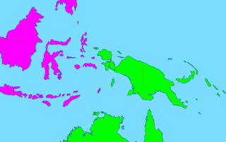
| 2011年9月18日 (日) 12:15 |  | 1,276 × 802(46 KB) | Maphobbyist(留言 | 贡献) | Map depicting continents according to plate tectonics. The Eastern Sunda Islands and the Moluccas are also part of the Asian tectonic plate. | |
| 2006年6月14日 (三) 12:41 |  | 1,276 × 802(47 KB) | Mac9(留言 | 贡献) | Category:Maps of Oceania Category:Maps of Asia |
您不可以覆盖此文件。
文件用途
没有页面使用本文件。