File:TransOceania.png
跳至導覽
跳至搜尋

預覽大小:800 × 503 像素。 其他解析度:320 × 201 像素 | 640 × 402 像素 | 1,024 × 644 像素 | 1,276 × 802 像素。
原始檔案 (1,276 × 802 像素,檔案大小:46 KB,MIME 類型:image/png)
說明
說明
添加單行說明來描述出檔案所代表的內容
摘要
[編輯]
| 描述 | |
| 日期 | Uploaded 23:53, 5 March 2005 (UTC) |
| 來源 | w:File:TransOceania.PNG (file now deleted). Image based on file from Amiglobe, which states "The data used in Amiglobe... are all public domain. Thus, maps and any document produced with Amiglobe 2006 can be use freely and without royalties." [1] |
| 作者 | User:Alinor |
| 其他版本 | File:TransOceania.PNG |
授權條款
[編輯]
| 此檔案採用創用CC 姓名標示-相同方式分享 3.0 未在地化版本授權條款。 受免責聲明的約束。 | ||
| ||
| 已新增授權條款標題至此檔案,作為GFDL授權更新的一部份。 |

|
已授權您依據自由軟體基金會發行的無固定段落、封面文字和封底文字GNU自由文件授權條款1.2版或任意後續版本,對本檔進行複製、傳播和/或修改。該協議的副本列在GNU自由文件授權條款中。 受免責聲明的約束。 |
檔案歷史
點選日期/時間以檢視該時間的檔案版本。
| 日期/時間 | 縮圖 | 尺寸 | 使用者 | 備註 | |
|---|---|---|---|---|---|
| 目前 | 2011年9月18日 (日) 12:35 | | 1,276 × 802(46 KB) | Maphobbyist(留言 | 貢獻) | Retouch |
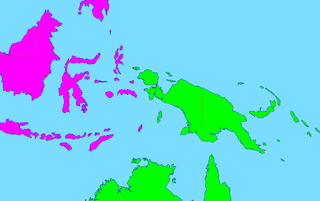
| 2011年9月18日 (日) 12:15 |  | 1,276 × 802(46 KB) | Maphobbyist(留言 | 貢獻) | Map depicting continents according to plate tectonics. The Eastern Sunda Islands and the Moluccas are also part of the Asian tectonic plate. | |
| 2006年6月14日 (三) 12:41 |  | 1,276 × 802(47 KB) | Mac9(留言 | 貢獻) | Category:Maps of Oceania Category:Maps of Asia |
無法覆蓋此檔案。
檔案用途
沒有使用此檔案的頁面。