File:Treblinka II aerial photo (1944).jpg
原始文件 (1,000 × 890像素,文件大小:704 KB,MIME类型:image/jpeg)
说明
说明
| 描述 |
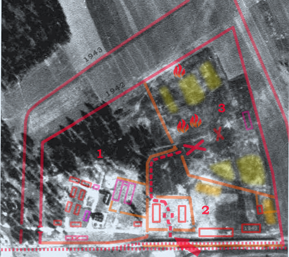
English: Treblinka II extermination camp of the Operation Reinhard in German-occupied Poland. Aerial photograph of the camp perimeter taken in 1944; several months after the dismantling of the camp. All known structrures are gone except for the farmhouse built within it and lifestock shed (lower left). The photograp is overlayed with the known structures as described on the map of Treblinka drawn by Mr. Peter Laponder, builder of the Treblinka Model at the new Cape Town Holocaust Center, digitized by ARC and made available at the Mapping Treblinka webpage. On the left hand side, the color outlines show dismantled SS and Hiwi guards living quarters with most barracks clearly defined by the surrounding walkways. The railway unloading platform (lower centre) consisted of two parallel ramps visible in the bottom, marked with the red arrow. Location of new expanded gass chambers marked with a cross. Undressing barracks and sorting yard (separate for men and women with hair-cropping area) marked with two rectangles surrounded by solid fence with no view of the outside. The adjacent "Sluice" through the woods separated by barb-wire fence, marked with red dashed-line. Polski: Zdjęcie lotnicze przedstawiające teren, na którym w okresie od lipca 1942 roku do listopada 1943 roku istniał niemiecki nazistowski obóz zagłady Treblinka II. Zdjęcie wykonano w 1944 roku, już po likwidacji obozu i zatarciu śladów jego istnienia. Widać na nim zabudowania „farmy”, na której Niemcy osiedlili dwóch ukraińskich wachmanów z zadaniem strzeżenia terenu poobozowego (u dołu, po lewej stronie). Na zdjęciu przy pomocy kolorowych konturów i innych znaków zaznaczono granice obozu, wewnętrzne ogrodzenia oraz miejsca, gdzie znajdowały się najważniejsze obiekty. Cyframi od 1 do 3 oznaczono strefy obozowe.
Source: Aerial Photos from the National Archives, Washington DC. Ref. No. GX 12225 SG, exp. 259.1) Strefa administracyjno-mieszkalna 2) Strefa przyjęć 3) Obszar zagłady (Totenlager) |
| 日期 | Before November 1944 (either September or October, according to different sources), roughly one month after the Soviet Army took over the area from under the Nazis. |
| 来源 | National Archives and Records Administration (ARC 2005) or much larger scan (CODOH) with greatly reduced contrast. Original from the National Archives Air Photo library at Alexandria, Virginia, U.S.A. Cartographic Division (Record Group 373). Some 1.2 million Nazi German air photographs were released into the public domain in the 1970s and 1980s by the National Archives. Numerous authors laid claims to have published them for the first time ever, notably the Holocaust denier and author John C. Ball (Air Photo Evidence)[1] and Udo Walendy (Der Fall Treblinka) before him. |
| 作者 | 未知, overlay legend in Photoshop by Poeticbent |
| 授权 (二次使用本文件) |
PD-Polish and EU |
這張照片屬於公有領域因為根據1926年3月29日波蘭版權法的Art. 31926年3月29日的版權法波蘭共和國和藝術。1952年7月10日版權法,波蘭人民共和國的在law於1994年5月23日更改之前出版的波蘭攝影師(或首次在波蘭出版或同時在波蘭和國外出版)是 假定在波蘭的公有領域。
本作品在美国属于公有领域,是因为符合下列三个条件:
致上傳者:請提供圖片首次發布的地點和時間。
|
 |
| 我,本作品著作权人,释出本作品至公有领域。这适用于全世界。 在一些国家这可能不合法;如果是这样的话,那么: 我无条件地授予任何人以任何目的使用本作品的权利,除非这些条件是法律规定所必需的。 |
文件历史
点击某个日期/时间查看对应时刻的文件。
| 日期/时间 | 缩略图 | 大小 | 用户 | 备注 | |
|---|---|---|---|---|---|
| 当前 | 2013年12月19日 (四) 17:42 | | 1,000 × 890(704 KB) | Poeticbent(留言 | 贡献) | missing barbed-wire fencing |
| 2013年8月18日 (日) 19:20 |  | 1,000 × 890(676 KB) | Poeticbent(留言 | 贡献) | {{Information |Description={{en|1=Treblinka II extermination camp of the Operation Reinhard in occupied Poland. Aerial photograph of the camp perimeter taken in 1944; several months after the dismantling of the camp. All known structrures are gone exce... |
您不可以覆盖此文件。
文件用途
没有页面使用本文件。
全域文件用途
以下其他wiki使用此文件:
- el.wikipedia.org上的用途
- en.wikipedia.org上的用途
- fr.wikipedia.org上的用途
- he.wikipedia.org上的用途
- it.wikipedia.org上的用途
- ja.wikipedia.org上的用途
- ml.wikipedia.org上的用途
- pl.wikipedia.org上的用途
- vi.wikipedia.org上的用途
- zh.wikipedia.org上的用途
.jpg&oldid=777662318)