File:Tropical Cyclone 12p (MODIS 2024-02-10).jpg
Jump to navigation
Jump to search

Size of this preview: 766 × 599 pixels. Other resolutions: 307 × 240 pixels | 614 × 480 pixels | 982 × 768 pixels | 1,280 × 1,001 pixels | 2,560 × 2,003 pixels | 6,824 × 5,339 pixels.
Original file (6,824 × 5,339 pixels, file size: 3.78 MB, MIME type: image/jpeg)
Captions
Captions
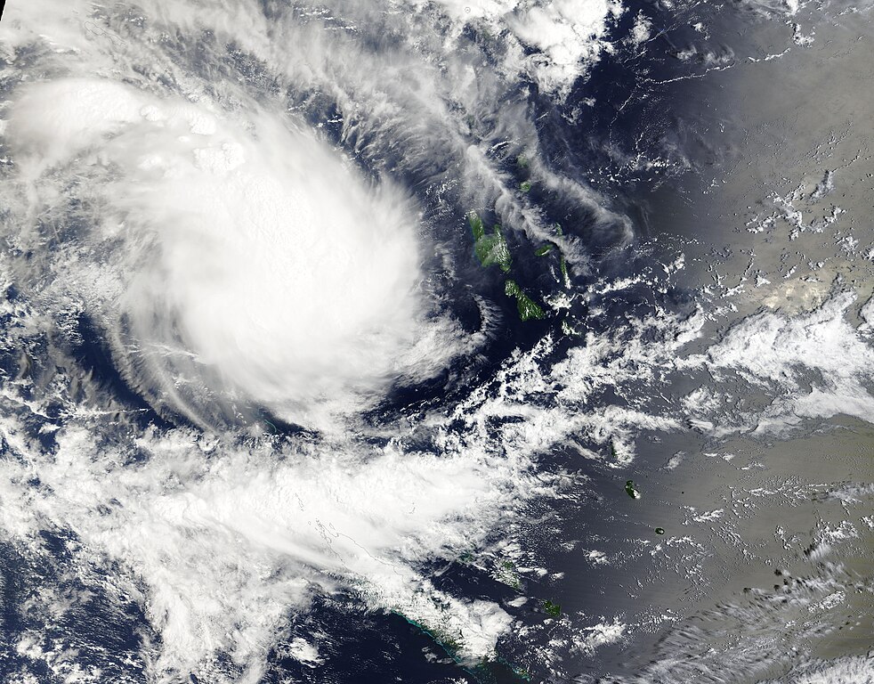
On February 7, 2024, the Moderate Resolution Imaging Spectroradiometer (MODIS) acquired a true-color image of a new tropical cyclone forming in the Coral Sea west of Vanuatu.
Summary
[edit].jpg&action=edit§ion=1)
| Description |
English: On February 7, 2024, the Moderate Resolution Imaging Spectroradiometer (MODIS) acquired a true-color image of a new tropical cyclone forming in the Coral Sea west of Vanuatu. Tropical Cyclone 12p was moving southeastward towards central Vanuatu and was carrying maximum sustained winds of about 45 mph (72.4 km/h) shortly after this image was captured. The green islands visible to the east of the storm include Espiritu Santo, Malakula, and Efate, all part of Vanuatu.
At 6:00 UTC (1:00 a.m. EST) on February 9, the center of 12p was located about 112 miles (180 km) northwest of Port Vila, Efate Island. It was carrying maximum sustained winds of about 40 mph (65 km/h). Although it is not an exceptionally strong storm, Tropical Cyclone 12p is expected to bring strong winds, surf, and heavy rain to Vanuatu as it travels between Efate and Erromango Islands on the morning of February 10. Maximum sustained winds of 46 mph (74 km/h) are forecast as it moves through the islands. By February 11 -12, the storm should be moving over the open waters of the South Pacific Ocean, where increasingly unfavorable conditions should cause it to dissipate by February 12. |
||
| Date | Taken on 7 February 2024 | ||
| Source |
Tropical Cyclone 12p (direct link)
|
||
| Author | MODIS Land Rapid Response Team, NASA GSFC |
| This media is a product of the Terra mission Credit and attribution belongs to the mission team, if not already specified in the "author" row |
Licensing
[edit].jpg&action=edit§ion=2)
| This file is in the public domain in the United States because it was solely created by NASA. NASA copyright policy states that "NASA material is not protected by copyright unless noted". (See Template:PD-USGov, NASA copyright policy page or JPL Image Use Policy.) | ||
 |
Warnings:
|
File history
Click on a date/time to view the file as it appeared at that time.
| Date/Time | Thumbnail | Dimensions | User | Comment | |
|---|---|---|---|---|---|
| current | 05:05, 10 February 2024 | | 6,824 × 5,339 (3.78 MB) | OptimusPrimeBot (talk | contribs) | #Spacemedia - Upload of http://modis.gsfc.nasa.gov/gallery/images/image02102024_250m.jpg via Commons:Spacemedia |
You cannot overwrite this file.
File usage on Commons
There are no pages that use this file.
.jpg&oldid=850477346)