File:Tropical Cyclone Joni 2009-03-12.jpg
From Wikimedia Commons, the free media repository
Jump to navigation
Jump to search

Size of this preview: 480 × 600 pixels. Other resolutions: 192 × 240 pixels | 384 × 480 pixels | 614 × 768 pixels | 819 × 1,024 pixels | 1,638 × 2,048 pixels | 6,400 × 8,000 pixels.
Original file (6,400 × 8,000 pixels, file size: 7.21 MB, MIME type: image/jpeg)
File information
Structured data
Captions
Captions
Add a one-line explanation of what this file represents
Summary[edit]
| DescriptionTropical Cyclone Joni 2009-03-12.jpg |
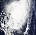
English: Late on March 10, a strong tropical disturbance formed about 770km (475 miles) west of Tahiti. Later that day multispectrial imagery had shown a well defined low level circulation center with formative convective banding wrapping well in to the center. Because of this, the JTWC issued a Tropical Cyclone Formation Alert on the developing system. Late the next day, RSMC Nadi designated the disturbance as Tropical Depression 11F and started to issue gale warnings for the Southern Cook Islands. Early on March 12, the JTWC designated the disturbance as Tropical Cyclone 20P, whilst later that day RSMC Nadi upgraded the Depression to a Tropical Cyclone and named it Joni. The Category Two Tropical Cyclone moved south of 25S late on March 12th. |
| Date | |
| Source | http://rapidfire.sci.gsfc.nasa.gov/realtime/single.php?2009071/crefl1_143.A2009071210000-2009071210500.4km.jpg |
| Author | NASA |
| Permission (Reusing this file) |
Public domain |
Licensing[edit]
| Public domainPublic domainfalsefalse |
| This file is in the public domain in the United States because it was solely created by NASA. NASA copyright policy states that "NASA material is not protected by copyright unless noted". (See Template:PD-USGov, NASA copyright policy page or JPL Image Use Policy.) |  | |
 |
Warnings:
|
File history
Click on a date/time to view the file as it appeared at that time.
| Date/Time | Thumbnail | Dimensions | User | Comment | |
|---|---|---|---|---|---|
| current | 00:12, 20 October 2020 |  | 6,400 × 8,000 (7.21 MB) | FleurDeOdile (talk | contribs) | 250m |
| 18:49, 10 August 2017 |  | 2,544 × 3,736 (1.42 MB) | FleurDeOdile (talk | contribs) | flattened | |
| 22:45, 13 March 2009 |  | 2,708 × 2,653 (1.38 MB) | HurricaneSpin (talk | contribs) | {{Information |Description={{en|1=Late on March 10, a strong tropical disturbance formed about 770km (475 miles) west of Tahiti. Later that day multispectrial imagery had shown a well defined low level circulation center with formative convective banding |
You cannot overwrite this file.
File usage on Commons
The following page uses this file:
File usage on other wikis
The following other wikis use this file:
- Usage on en.wikipedia.org
- Usage on pt.wikipedia.org
- Usage on zh.wikipedia.org