File:Tropical Storm Fred (MODIS 2021-08-17).jpg

Original file (7,938 × 6,214 pixels, file size: 6.33 MB, MIME type: image/jpeg)
Captions
Captions
Summary
[edit].jpg&action=edit§ion=1)
| Description |
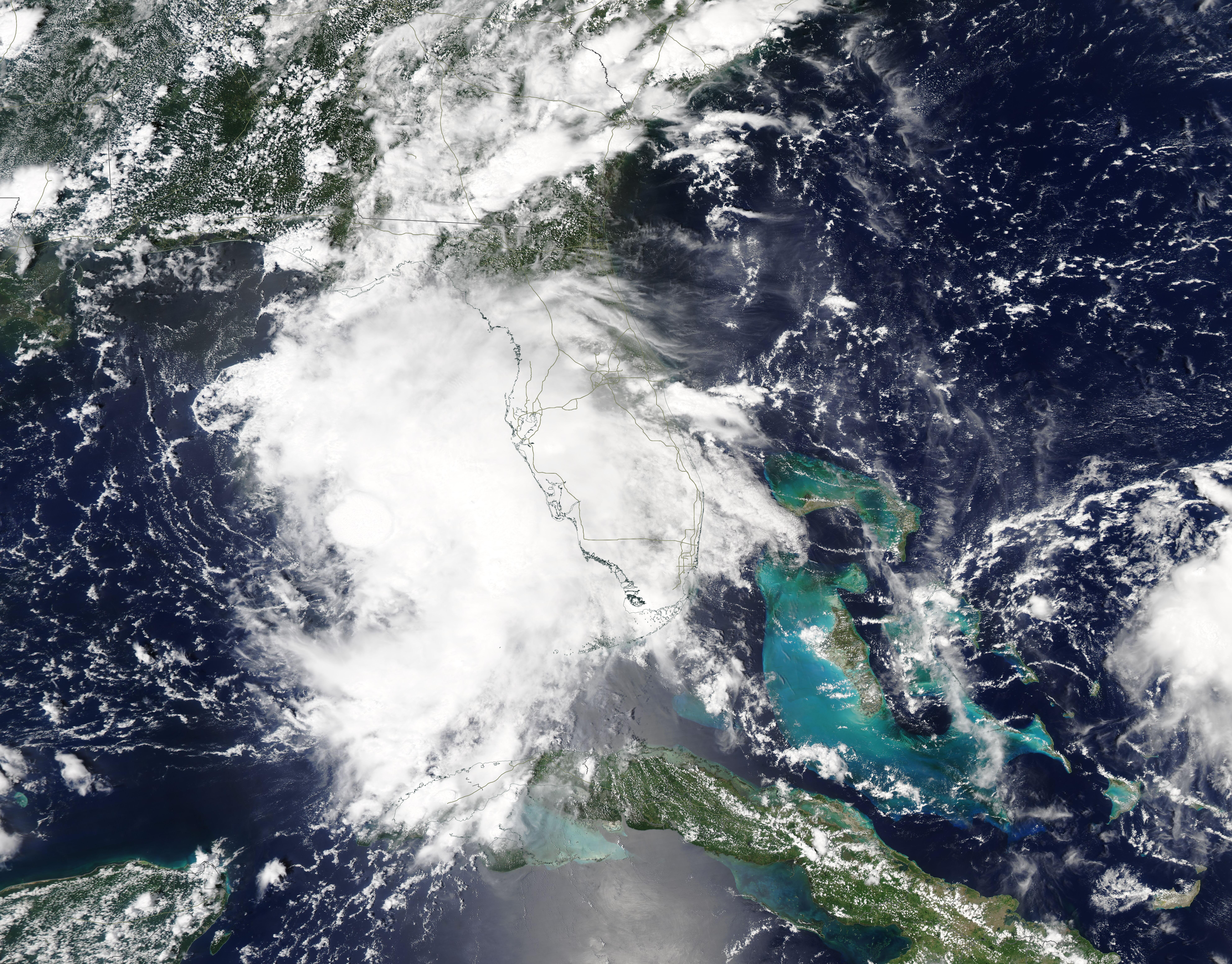
English: Tropical Storm Fred made landfall near Cape San Blas, Florida on the afternoon of August 16. According to the National Hurricane Center (NHC), the storm came ashore at about 2:50 p.m. EDT (1950 UTC) carrying maximum sustained winds near 65 mph (100 km/h). It was moving north-northeast at 9 mph (15 km). The center of the storm was only 25 miles (40 km) west of Apalachicola, Florida at that time.
Cape San Blas sits on the southern tip of a peninsula that extends westward from the Florida Mainland, then turns northward near Cape San Blas to separate St. Joseph Bay from the Gulf of Mexico. It sits close to Elgin Air Force Base, 10 miles (15 km) and south-southwest of Port St. Joe. Gulf County Emergency Management said that Tropical Storm Fred had knocked down several trees, parts of the county had measured 7 inches of rain, and Indian Pass Road was closed under five feet or water, but that storm surge was minimal. Early reports did not give indication of injuries near the landfall location. A later report, from the Tallahassee Democrat, stated that dangerous storm surge inundation was ongoing along portions of the coast of the Florida Panhandle and the Florida Big Bend Region. After coming ashore, Fred retained tropical storm status. At 8:00 p.m. EDT on August 16 (0000 UTC August 17), the NHC advised that Tropical Storm Fred continued to move inland, bringing with it heavy rain. At that time, Tropical Storm Fred was located 15 miles (20 km) south of Marianna, Florida and was travelling north-northeast at 10 mph. Maximum sustained winds were estimated at 50 mph (85 km/h), with higher gusts. Fred is expected to continue the same general motion with increasing forward speed over the next couple of days. The NHC forecasts that Fred will move from western Georgia on August 17 across the Southern Appalachian Mountains to reach West Virginia by August 18. Rapid weakening is expected, with Fred expected to become a depression by August 17. Tropical-storm-force winds extend outward up to 115 miles (185 km) from the center. Heavy rain can be expected across parts of the Southeast and Mid-Atlantic along with significant flooding in some areas. The NHC advises that an increased risk of landslides exist across the mountains of North Carolina as well as portions of the Blue Ridge Escarpment on August 17. The Moderate Resolution Imaging Spectroradiometer (MODIS) on board NASA’s Terra satellite acquired this true-color image of Tropical Storm Fred as it churned over the eastern Gulf of Mexico on August 15. A cloud-filled, consolidated eye can be seen near the center of circulation of the very large storm. On the western side of the center, convection has been diminished by wind shear. Cape San Blas sits nearly due north of the center. |
||
| Date | Taken on 15 August 2021 | ||
| Source |
Tropical Storm Fred (direct link)
|
||
| Author | MODIS Land Rapid Response Team, NASA GSFC |
| This media is a product of the Aqua mission Credit and attribution belongs to the mission team, if not already specified in the "author" row |
Licensing
[edit].jpg&action=edit§ion=2)
| This file is in the public domain in the United States because it was solely created by NASA. NASA copyright policy states that "NASA material is not protected by copyright unless noted". (See Template:PD-USGov, NASA copyright policy page or JPL Image Use Policy.) | ||
 |
Warnings:
|
File history
Click on a date/time to view the file as it appeared at that time.
| Date/Time | Thumbnail | Dimensions | User | Comment | |
|---|---|---|---|---|---|
| current | 17:33, 30 January 2024 | | 7,938 × 6,214 (6.33 MB) | OptimusPrimeBot (talk | contribs) | #Spacemedia - Upload of http://modis.gsfc.nasa.gov/gallery/images/image08172021_250m.jpg via Commons:Spacemedia |
You cannot overwrite this file.
File usage on Commons
There are no pages that use this file.
.jpg&oldid=847284747)