File:Tropical Storm Gorgette (MODIS 2022-08-06).jpg

Original file (6,193 × 4,503 pixels, file size: 3.34 MB, MIME type: image/jpeg)
Captions
Captions
Summary
[edit].jpg&action=edit§ion=1)
| Description |
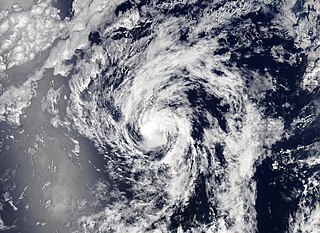
English: On July 27, 2022, the eighth named storm of the Eastern Pacific Hurricane Season formed about 555 miles (895 km) southwest of the southern tip of Baja California. The system was named Georgette that evening as maximum sustained winds reached 45 mph (75 km/h).
Tropical Storm Georgette stayed away from land, moving generally westward over open waters. Maximum sustained winds peaked at 50 mph (80.5 km/h) by early on July 28 and retained that windspeed through July 31. After that time, Georgette began to battle increasing vertical windshear, causing the storm to weaken and turn towards the north. Late on July 31, maximum sustained winds dropped to 35 mph (56.3 km/h) and stayed at that strength through the morning of August 3. The National Hurricane Center (NHC) issued the last advisory on Georgette at 2100 UTC (5:00 p.m. EDT) on August 3. At that time, Georgette had degenerated into a remnant low, with maximum sustained winds of only 30 mph (45 km/h). It was located about 1,310 miles (2,110 km) west-southwest of the southern tip of Baja California and was moving nearly due north at 8 mph (13 km/h). On August 3, the Moderate Resolution Imaging Spectroradiometer (MODIS) on board NASA’s Aqua satellite acquired a true-color image of Georgette close to the time the storm weakened to a remnant low and took a turn westward. At the time the image was acquired, Georgette retained weak convection around a cloud-filled center but had become elongated and asymmetric. |
||
| Date | Taken on 3 August 2022 | ||
| Source |
Tropical Storm Gorgette (direct link)
|
||
| Author | MODIS Land Rapid Response Team, NASA GSFC |
| This media is a product of the Aqua mission Credit and attribution belongs to the mission team, if not already specified in the "author" row |
Licensing
[edit].jpg&action=edit§ion=2)
| This file is in the public domain in the United States because it was solely created by NASA. NASA copyright policy states that "NASA material is not protected by copyright unless noted". (See Template:PD-USGov, NASA copyright policy page or JPL Image Use Policy.) | ||
 |
Warnings:
|
File history
Click on a date/time to view the file as it appeared at that time.
| Date/Time | Thumbnail | Dimensions | User | Comment | |
|---|---|---|---|---|---|
| current | 21:54, 9 January 2024 | | 6,193 × 4,503 (3.34 MB) | OptimusPrimeBot (talk | contribs) | #Spacemedia - Upload of http://modis.gsfc.nasa.gov/gallery/images/image08062022_250m.jpg via Commons:Spacemedia |
You cannot overwrite this file.
File usage on Commons
There are no pages that use this file.
.jpg&oldid=840285682)