File:Tropical Storm Olaf (MODIS 2021-09-10).jpg

Original file (6,764 × 5,642 pixels, file size: 4.9 MB, MIME type: image/jpeg)
Captions
Captions
Summary
[edit].jpg&action=edit§ion=1)
| Description |
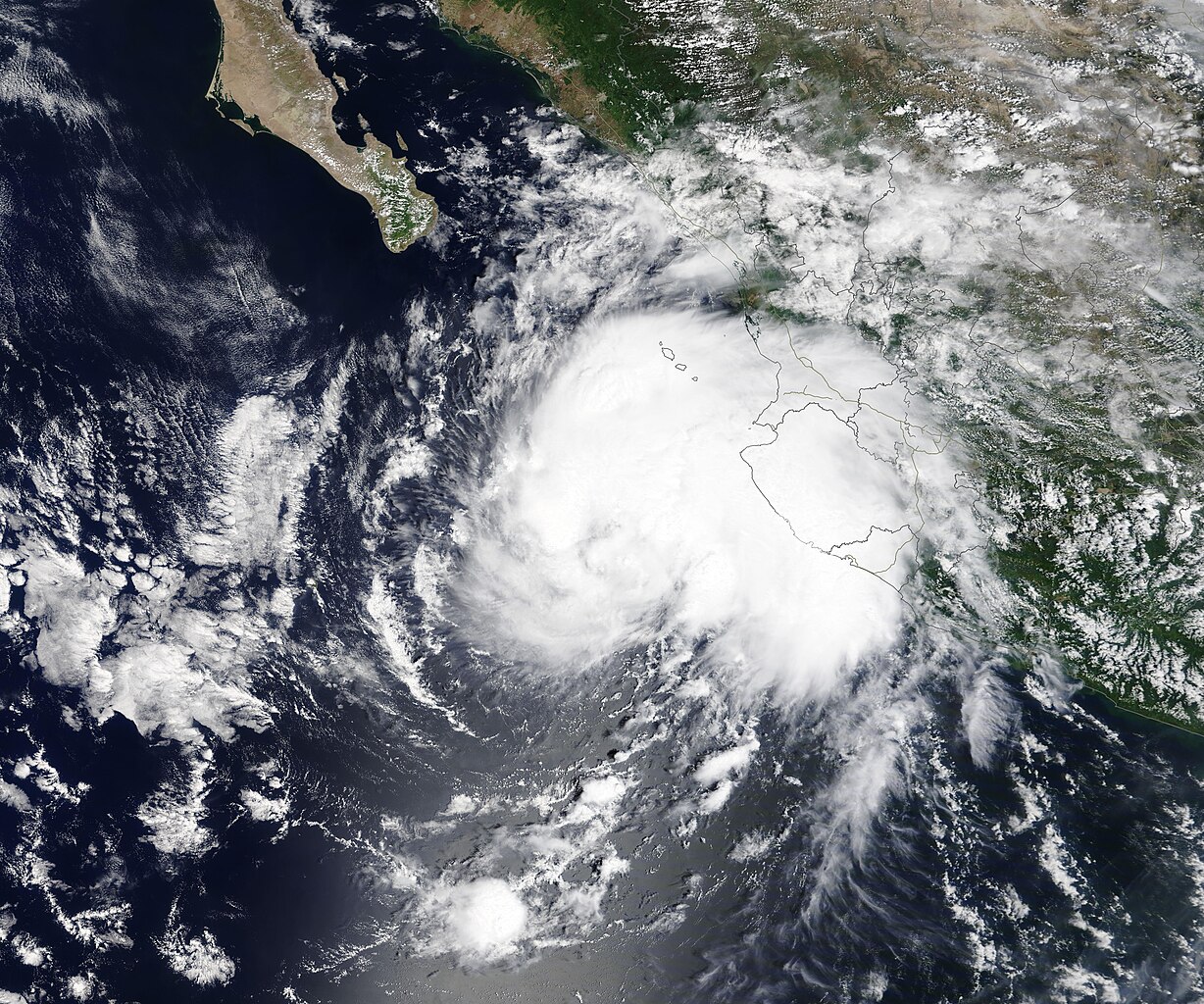
English: On September 8, 2021, the Moderate Resolution Imaging Spectroradiometer (MODIS) on board NASA’s Terra satellite acquired a true-color image of Tropical Storm Olaf spinning in the Pacific Ocean off of the coast of Central Mexico. By the morning of September 9, the storm reached hurricane strength and was threatening landfall over Mexico.
According to the National Hurricane Center (NHC), at 5:00 p.m. EDT (2100 UTC) on September 9, the eyewall of Hurricane Olaf was nearing the coast of the southern Baja California Peninsula of Mexico. Hurricane warnings were in effect from Los Barriles to Cabo San Lazaro, Mexico and a Tropical Storm Warning was in effect for Baja California Sur, north of Cabo San Lazaro to Puerto San Andresito and Baja California Sur north of Los Barriles to Loreto, Mexico. At that time, Olaf was carrying maximum sustained winds of 90 mph (145 km/h), placing it as a Category 1 hurricane on the Saffir Simpson Hurricane Wind Scale. Hurricane Olaf is forecast to continue to move towards the north-northwest through the evening of September 9, then turn slightly to the northwest on September 10. By September 11-12, the track should carry the storm westward. The center of Olaf is expected to continue to approach the southern coast of the Baja California peninsula on September 9, moving very near or over the peninsula on September 10-11. According to the NHC, additional strengthening is possible before Hurricane Olaf begins to interact with land, but after that time it should begin to weaken as it turns to move away from land. |
||
| Date | Taken on 8 September 2021 | ||
| Source |
Tropical Storm Olaf (direct link)
|
||
| Author | MODIS Land Rapid Response Team, NASA GSFC |
| This media is a product of the Terra mission Credit and attribution belongs to the mission team, if not already specified in the "author" row |
Licensing
[edit].jpg&action=edit§ion=2)
| This file is in the public domain in the United States because it was solely created by NASA. NASA copyright policy states that "NASA material is not protected by copyright unless noted". (See Template:PD-USGov, NASA copyright policy page or JPL Image Use Policy.) | ||
 |
Warnings:
|
File history
Click on a date/time to view the file as it appeared at that time.
| Date/Time | Thumbnail | Dimensions | User | Comment | |
|---|---|---|---|---|---|
| current | 18:47, 29 January 2024 | | 6,764 × 5,642 (4.9 MB) | OptimusPrimeBot (talk | contribs) | #Spacemedia - Upload of http://modis.gsfc.nasa.gov/gallery/images/image09102021_250m.jpg via Commons:Spacemedia |
You cannot overwrite this file.
File usage on Commons
There are no pages that use this file.
.jpg&oldid=846901323)