File:Tulip beds location and exposures PLoS ONE 7(1) e29233 fig 1.TIF
Jump to navigation
Jump to search

Size of this JPG preview of this TIF file: 580 × 599 pixels. Other resolutions: 232 × 240 pixels | 464 × 480 pixels | 743 × 768 pixels | 991 × 1,024 pixels | 2,068 × 2,137 pixels.
Original file (2,068 × 2,137 pixels, file size: 8.17 MB, MIME type: image/tiff)
Captions
Captions
Add a one-line explanation of what this file represents
Summary
[edit]| Description |
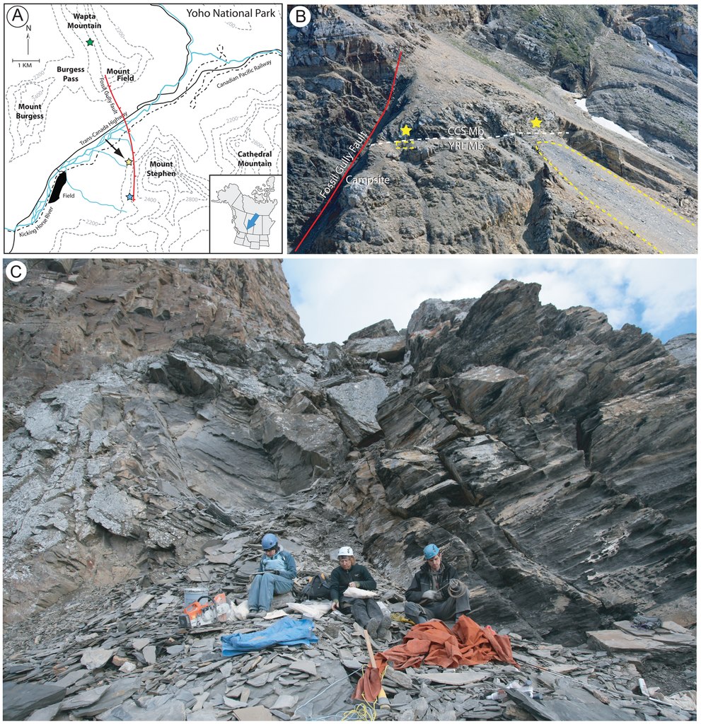
English: Original figure caption: A, position of the site (yellow star next to arrow), in relation to the Walcott Quarry (green star) and the Trilobite Beds (blue star). (The GPS coordinates for the locality are 51°24′06.1″N, 116°27′06.4″W). B, telephoto of the Tulip Beds from Mount Field, showing the location of the main fossiliferous outcrops (yellow stars). Fossils were collected from two talus slopes (yellow dashed lines) or in situ in the Above Camp outcrop (yellow star on the left), now represented by a small quarry. The yellow star on the right indicates the approximate extent of the Above Camp fossil bearing layers to the southeast (distance between the two outcrops approximately 200 meters). The white dashed line indicates the boundary between the Campsite Cliff Shale Member (CCS) above and the Yoho River Limestone Member (YRL) below. C, close-up view of the Above Camp quarry in the summer of 2010 (yellow star on the left in B), showing the location of the fossiliferous beds excavated by the Royal Ontario Museum (small quarry just above crew members).
Deutsch: Original-Bildunterschrift (Übersetzung): A, Lage der Grabungsstätte (gelber Stern neben dem Pfeil) in Bezug zum Walcott Quarry (grüner Stern) und den Trilobite Beds (blauer Stern). (Die GPS-Koordinaten für die Lokalität lauten 51°24′06.1″N, 116°27′06.4″W). B, eine Teleobjektiv-Aufnahme der Tulip Beds vom Mount Field aus zeigt die Lage der wichtigsten Aufschlüsse mit fossilführenden Schichten (gelbe Sterne). Fossilien wurden in Hangschuttkegeln (gestrichelte gelbe Linien) oder in situ im Above-Camp-Aufschluss (linker gelber Stern), der mittlerweile ein kleiner Steinbruch ist, aufgesammelt. Der rechte gelbe Stern markiert die ungefähre Erstreckung der Above-Camp-Fossilschichten nach Südosten (Abstand zwischen den beiden Aufschlüssen annähernd 200 Meter). Die weiße gestrichelte Linie markiert die Grenze zwischen dem Campsite Cliff Shale Member (CCS) und dem unterlagernden Yoho River Limestone Member (YRL). C, eine Nahaufnahme des Above-Camp-Steinbruchs im Sommer 2010 (linker gelber Stern in B) zeigt die Lage der fossilführenden Schichten, in denen das Royal Ontario Museum gegraben hat (der kleine Steinbruch direkt oberhalb der Grabungsteilnehmer). |
| Date | |
| Source | Fig. 1 in A New Stalked Filter-Feeder from the Middle Cambrian Burgess Shale, British Columbia, Canada. PLoS ONE 7(1): e29233, doi:10.1371/journal.pone.0029233 |
| Author | Lorna J. O’Brien, Jean-Bernard Caron |
| Other versions |
.png)
Licensing
[edit]|
This file is licensed under the Creative Commons Attribution 2.5 Generic license.
|
This file was published in a Public Library of Science journal. Their website states that the content of all PLOS journals is published under the Creative Commons Attribution 4.0 license (or its previous version depending on the publication date), unless indicated otherwise.
|
File history
Click on a date/time to view the file as it appeared at that time.
| Date/Time | Thumbnail | Dimensions | User | Comment | |
|---|---|---|---|---|---|
| current | 18:38, 7 November 2016 |  | 2,068 × 2,137 (8.17 MB) | Gretarsson (talk | contribs) | {{Information |Description ={{en|1=Original figure caption: ''A, position of the site (yellow star next to arrow), in relation to the Walcott Quarry (green star) and the Trilobite Beds (blue star). (The GPS coordinates for the locality are 51°24′... |
You cannot overwrite this file.
File usage on Commons
The following page uses this file: