File:Turkic language map-present range.png
Jump to navigation
Jump to search
No higher resolution available.
Turkic_language_map-present_range.png (527 × 220 pixels, file size: 15 KB, MIME type: image/png)
Captions
Captions
Add a one-line explanation of what this file represents
Summary[edit]

|
This linguistic map image could be re-created using vector graphics as an SVG file. This has several advantages; see Commons:Media for cleanup for more information. If an SVG form of this image is available, please upload it and afterwards replace this template with
{{vector version available|new image name}}.
It is recommended to name the SVG file “Turkic language map-present range.svg”—then the template Vector version available (or Vva) does not need the new image name parameter. |

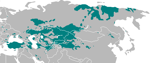
| Description | Geographical distribution of Turkic-speaking peoples across Eurasia where Turkic languages are spoken today. |
| Date | 20 August 2006 (original upload date) |
| Source | Transferred from en.wikipedia to Commons. |
| Author |
Khosrow II at English Wikipedia Later versions were uploaded by Aivazovsky, Tajik, Citynoise, Dbachmann, Zaparojdik at en.wikipedia. |
Licensing[edit]
| This work has been released into the public domain by its author, Khosrow II at English Wikipedia. This applies worldwide. In some countries this may not be legally possible; if so: Khosrow II grants anyone the right to use this work for any purpose, without any conditions, unless such conditions are required by law. |
Original upload log[edit]
The original description page was here. All following user names refer to en.wikipedia.
- 2006-11-21 20:26 Zaparojdik 480×223×8 (12592 bytes) Some incorrect speaking regions changed in Bulgaria, added Bayan-Ölgiy Province of Mongolia. Laz speaking region is updated.
- 2006-10-17 08:18 Dbachmann 480×223×8 (9583 bytes) cropped
- 2006-09-14 21:27 Citynoise 586×339×8 (15254 bytes) Reverted to earlier revision
- 2006-08-26 03:00 Tajik 586×339×8 (15254 bytes) Reverted to earlier revision
- 2006-08-26 02:59 Tajik 586×339×8 (20112 bytes) Reverted to earlier revision
- 2006-08-20 23:55 Aivazovsky 586×339×8 (15254 bytes) Adding Northern Cyprus and Iraqi Turkmen of Iraq. De-highlighting Laz and Georgian-speaking areas of northeastern Turkey.
- 2006-08-20 20:18 Khosrow II 586×339×8 (20112 bytes) Hopefully this is going to be the last one! LOL, Turkic Linguistic map.
File history
Click on a date/time to view the file as it appeared at that time.
| Date/Time | Thumbnail | Dimensions | User | Comment | |
|---|---|---|---|---|---|
| current | 21:24, 13 October 2021 | | 527 × 220 (15 KB) | Golden (talk | contribs) | updating Karabakh; Talysh isn't majority in these areas; Azeris form majority in Tabriz and Maku. |
| 00:00, 29 April 2021 |  | 527 × 220 (13 KB) | Kaldari (talk | contribs) | Reverting to stable version prior to edit war. Disputed changes to maps must be uploaded as new separate files per Commons:Overwriting existing files | |
| 21:00, 28 April 2021 |  | 527 × 220 (64 KB) | Mahammad tt (talk | contribs) | Reverted to version as of 07:08, 25 April 2021 (UTC) | |
| 18:19, 28 April 2021 |  | 527 × 220 (13 KB) | HistoryofIran (talk | contribs) | rv, disruption | |
| 07:08, 25 April 2021 |  | 527 × 220 (64 KB) | Mahammad tt (talk | contribs) | ||
| 17:06, 25 April 2019 |  | 527 × 220 (13 KB) | Satoshi Kondo (talk | contribs) | Correction according to the distribution of Turkic languages and peoples | |
| 13:38, 25 March 2019 |  | 527 × 220 (10 KB) | Gogolplex (talk | contribs) | Reverted to version as of 11:17, 26 September 2018 (UTC) It's not a politic map, it shows the distribution of Turkic languages, not Turkic countries. | |
| 17:43, 1 January 2019 |  | 527 × 220 (11 KB) | Satoshi Kondo (talk | contribs) | nations with turkic as only language, buyeo-turks and sakha-yakut correction | |
| 11:17, 26 September 2018 |  | 527 × 220 (10 KB) | Saguamundi (talk | contribs) | Reverted to version as of 22:01, 6 May 2017 (UTC) | |
| 14:13, 8 May 2017 |  | 527 × 220 (13 KB) | 일성강 (talk | contribs) | the most north eastern turkic language is yakut language |
You cannot overwrite this file.
File usage on Commons
The following 12 pages use this file:
- User:Chumwa/OgreBot/Travel and communication maps/2017 April 21-30
- User:Chumwa/OgreBot/Travel and communication maps/2017 May 1-10
- User:Chumwa/OgreBot/Travel and communication maps/2018 September 21-30
- User:Chumwa/OgreBot/Travel and communication maps/2019 January 1-10
- User:Chumwa/OgreBot/Travel and communication maps/2019 March 21-31
- User:Chumwa/OgreBot/Travel and communication maps/2021 April 21-30
- User:Chumwa/OgreBot/Travel and communication maps/2021 October 11-20
- File:Turkic language map3.PNG (file redirect)
- File talk:Turkic language map-present range.png
File usage on other wikis
The following other wikis use this file:
- Usage on an.wikipedia.org
- Usage on azb.wikipedia.org
- Usage on ba.wikipedia.org
- Usage on bn.wikipedia.org
- Usage on ca.wikipedia.org
- Usage on ce.wikipedia.org
- Usage on cs.wikipedia.org
- Usage on da.wikipedia.org
- Usage on el.wikipedia.org
- Usage on en.wikipedia.org
- Usage on es.wikipedia.org
- Usage on et.wikipedia.org
- Usage on fi.wikipedia.org
- Usage on hi.wikipedia.org
- Usage on hy.wikipedia.org
- Usage on id.wikipedia.org
- Usage on it.wikipedia.org
- Usage on ja.wikipedia.org
- Usage on krc.wikipedia.org
- Usage on lt.wikipedia.org
- Usage on lv.wikipedia.org
- Usage on mzn.wikipedia.org
View more global usage of this file.