File:Typhoon Nakri (MODIS 2019-11-09).jpg
Jump to navigation
Jump to search

Size of this preview: 720 × 600 pixels. Other resolutions: 288 × 240 pixels | 576 × 480 pixels | 922 × 768 pixels | 1,229 × 1,024 pixels | 2,458 × 2,048 pixels | 7,750 × 6,458 pixels.
Original file (7,750 × 6,458 pixels, file size: 4.59 MB, MIME type: image/jpeg)
Captions
Captions
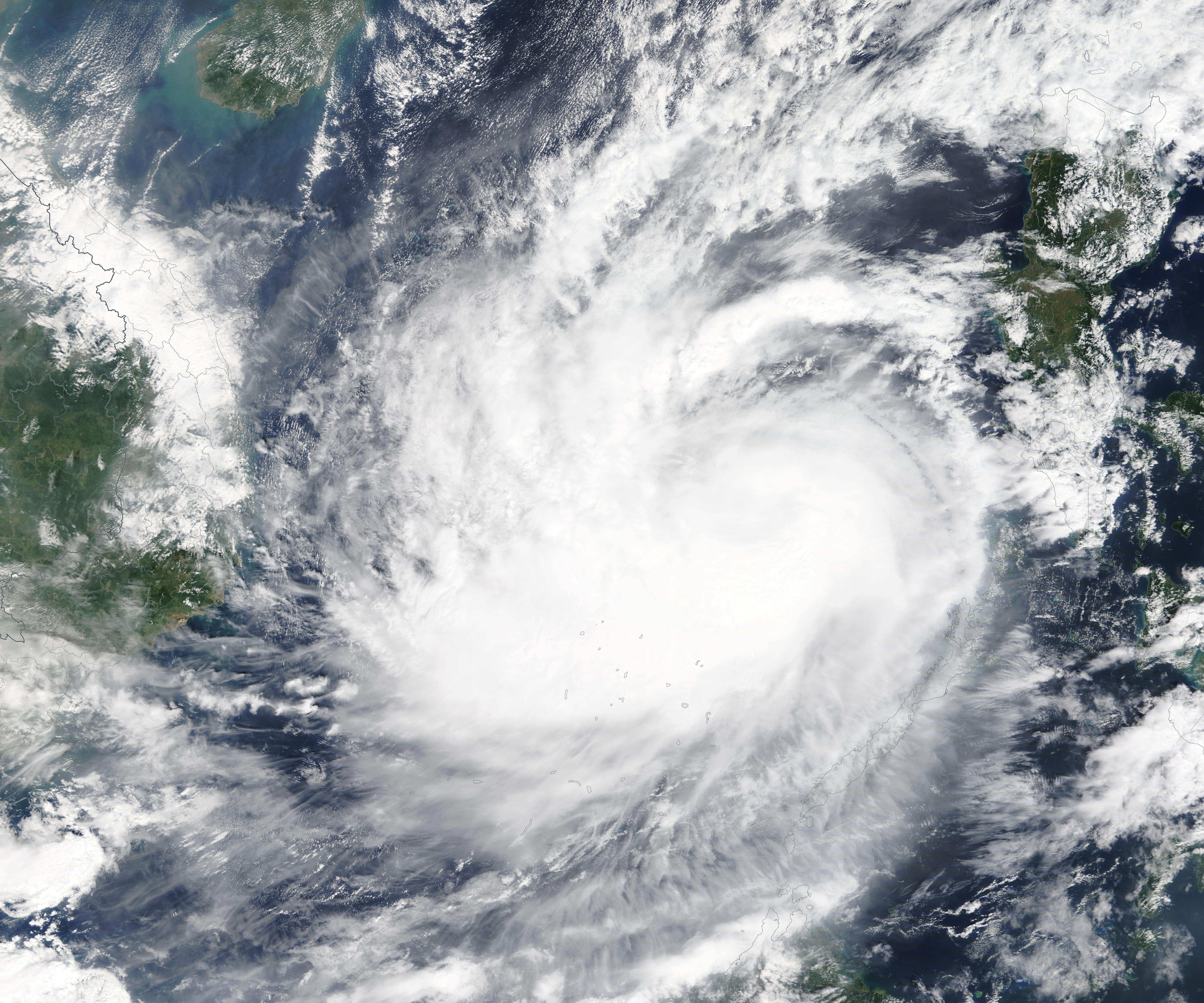
The Moderate Resolution Imaging Spectroradiometer (MODIS) on board NASA’s Terra satellite acquired a true-color image of Nakri as the storm was strengthening and becoming more organized on that same day.
Summary
[edit].jpg&action=edit§ion=1)
| Description |
English: Former Tropical Storm Nakri strengthened into a typhoon over the South China Sea on November 8, 2019. The Moderate Resolution Imaging Spectroradiometer (MODIS) on board NASA’s Terra satellite acquired a true-color image of Nakri as the storm was strengthening and becoming more organized on that same day. The largest bands of thunderstorms were located southwest of center and were wrapping into the low-level center. Although Typhoon Nakri was still west of the main Philippine Islands and north of Palawan, Kalayaan was still feeling effects from the storm.
Kalayaan is a municipality on Pagasa Island in the province of Palawan, Philippines. Kalayaan is part of the Spratly Group of Islands, west of the largest island of Palawan. Nakri is known in the Philippines as Quiel. On November 8 at 10 a.m. EST (1500 UTC), the Joint Typhoon Warning Center (JTWC) reported Nakri’s maximum sustained winds had increased to near 65 knots (75 mph/120 km/h). The intensity is expected to remain relatively steady in the near-term. Nakri was located near latitude 12.7 degrees north and longitude 116.1 degrees east, about 291 nautical miles west-southwest of Manila, Philippines. Nakri is moving slowly to the west. JTWC expects Nakri to slowly track westward and make landfall in Vietnam late on November 10 or early November 11, to the south of Danang. Vietnam’s National Center for Hydro-Meteorological Forecasting issued a Typhoon Warning for the country as Nakri approaches. The Global Disaster Alert and Coordination Center (GDACS) reports that very heavy rainfall, strong winds, and storm surges are forecast over central-southern Vietnam as well as north-eastern Cambodia on November 8-10. |
||
| Date | Taken on 8 November 2019 | ||
| Source |
|
||
| Author | MODIS Land Rapid Response Team, NASA GSFC |
| This media is a product of the Terra mission Credit and attribution belongs to the mission team, if not already specified in the "author" row |
Licensing
[edit].jpg&action=edit§ion=2)
| This file is in the public domain in the United States because it was solely created by NASA. NASA copyright policy states that "NASA material is not protected by copyright unless noted". (See Template:PD-USGov, NASA copyright policy page or JPL Image Use Policy.) | ||
 |
Warnings:
|
File history
Click on a date/time to view the file as it appeared at that time.
| Date/Time | Thumbnail | Dimensions | User | Comment | |
|---|---|---|---|---|---|
| current | 02:54, 17 February 2024 | | 7,750 × 6,458 (4.59 MB) | OptimusPrimeBot (talk | contribs) | #Spacemedia - Upload of http://modis.gsfc.nasa.gov/gallery/images/image11092019_250m.jpg via Commons:Spacemedia |
You cannot overwrite this file.
File usage on Commons
There are no pages that use this file.
.jpg&oldid=852935510)