File:US nuclear strike map.svg
跳转到导航
跳转到搜索

此SVG文件的PNG预览的大小:800 × 497像素。 其他分辨率:320 × 199像素 | 640 × 397像素 | 1,024 × 636像素 | 1,280 × 795像素 | 2,560 × 1,590像素 | 950 × 590像素。
原始文件 (SVG文件,尺寸为950 × 590像素,文件大小:81 KB)
说明
说明
添加一行文字以描述该文件所表现的内容
Another amatuerish posting with no description of what is actually SHOWN, are we supposed to guess?
摘要
[编辑]
| 描述 |
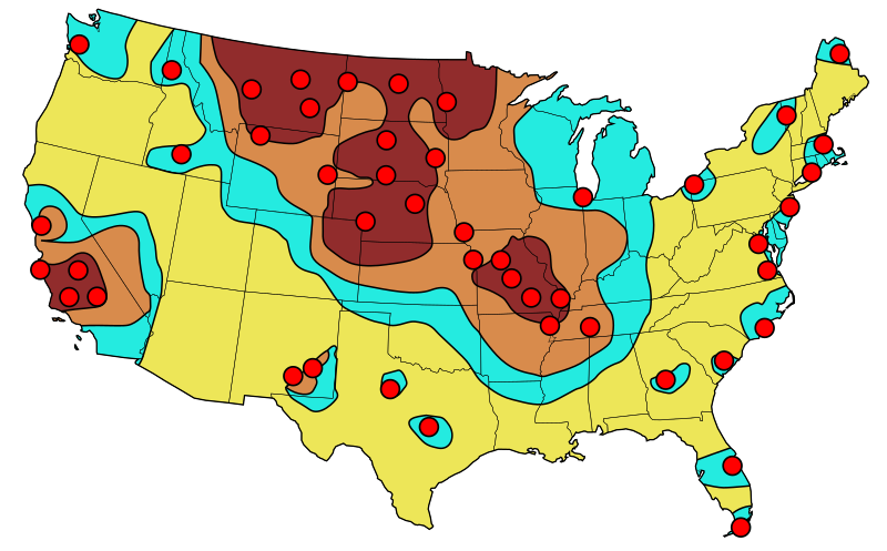
English: Primary target locations for Soviet nuclear strikes during 1980s. The resulting fall-out is indicated with the darkest considered as "lethal" to relatively fall-out free yellow zones. |
| 日期 | (UTC), based on an image published in 1984 |
| 来源 | |
| 作者 |
|
Original source information
[编辑]
Federal Emergency Management Agency (FEMA), "Disaster Relief Preparatory Manual for the Washington-DC Metro Area", page 79, re-published 1984 (original publication 1974)
Original source information: FEMA, 500 C St SW, Washington DC 20472 and the phone is (202) 646-2500
许可协议
[编辑]
我,本作品著作权人,特此采用以下许可协议发表本作品:
| 本作品采用知识共享CC0 1.0 通用公有领域贡献许可协议授权。 | |
| 采用本宣告发表本作品的人,已在法律允许的范围内,通过在全世界放弃其对本作品拥有的著作权法规定的所有权利(包括所有相关权利),将本作品贡献至公有领域。您可以复制、修改、传播和表演本作品,将其用于商业目的,无需要求授权。
|
|
|
原始上传日志
[编辑]
This image is a derivative work of the following images:
- File:USnuclearstrike.jpg licensed with Cc-pd-mark-footer, PD-USGov
- 2011-03-02T16:51:30Z Quibik 613x410 (34734 Bytes) == {{int:filedesc}} == {{Information |Description = {{en|Primary target locations for Soviet nuclear strikes during the Cold War showing resulting fall-out zones.}} |Source = [[:en:Federal Emergency Management Agency]] (Origi
- File:Blank_US_Map.svg licensed with Cc-by-sa-3.0-migrated, GFDL
- 2009-11-05T19:44:02Z NuclearVacuum 959x593 (91518 Bytes) minor fix from previous upload
- 2009-11-05T19:39:42Z NuclearVacuum 959x593 (88399 Bytes) Fixed up the borders so they are connected with each state and loosing that gap between them.
- 2008-10-09T16:36:40Z Howcheng 959x593 (80121 Bytes) Reverted to version as of 08:32, 14 June 2007
- 2008-03-12T00:20:02Z AMK1211 959x593 (174744 Bytes) Added borders: Light blue for water borders and black for land borders (international borders thicker).
- 2007-06-14T08:32:47Z Fibonacci 959x593 (80121 Bytes) Optimised code.
- 2006-07-12T23:00:30Z Theshibboleth 959x593 (90537 Bytes) The line framework around Alaska and Hawaii has been pushed a bit
- 2006-07-12T06:35:19Z Theshibboleth 959x593 (89828 Bytes) added DC
- 2006-07-12T06:05:05Z Theshibboleth 959x593 (89649 Bytes) {{Information |Description=A blank map of the United States in scalable vector form. |Source=Own work, based on [[:Image:Electorial map.svg]], inspired by [[:Image:BlankMap-World.png]] |Date=11 July 2006 |Author=[[User:Theshi
Uploaded with derivativeFX
文件历史
点击某个日期/时间查看对应时刻的文件。
| 日期/时间 | 缩略图 | 大小 | 用户 | 备注 | |
|---|---|---|---|---|---|
| 当前 | 2011年3月2日 (三) 17:12 | | 950 × 590(81 KB) | Quibik(留言 | 贡献) | tweaked the SW corner |
| 2011年3月2日 (三) 17:01 |  | 950 × 590(80 KB) | Quibik(留言 | 贡献) | == {{int:filedesc}} == {{Information |Description={{en|Primary target locations for Soviet nuclear strikes during the Cold War showing resulting fall-out zones.}} |Source=*File:USnuclearstrike.jpg *File:Blank_US_Map.svg |Date=2011-03-02 16:58 |
您不可以覆盖此文件。
文件用途
以下页面使用本文件:
全域文件用途
以下其他wiki使用此文件:
- el.wikipedia.org上的用途
- en.wikipedia.org上的用途
- hy.wikipedia.org上的用途
- ru.wikipedia.org上的用途
- zh.wikipedia.org上的用途