File:US nuclear strike map.svg
跳至導覽
跳至搜尋

此 SVG 檔案的 PNG 預覽的大小:800 × 497 像素。 其他解析度:320 × 199 像素 | 640 × 397 像素 | 1,024 × 636 像素 | 1,280 × 795 像素 | 2,560 × 1,590 像素 | 950 × 590 像素。
原始檔案 (SVG 檔案,表面大小:950 × 590 像素,檔案大小:81 KB)
說明
說明
添加單行說明來描述出檔案所代表的內容
Another amatuerish posting with no description of what is actually SHOWN, are we supposed to guess?
摘要
[編輯]
| 描述 |
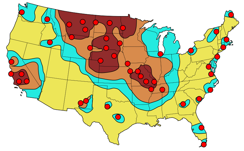
English: Primary target locations for Soviet nuclear strikes during 1980s. The resulting fall-out is indicated with the darkest considered as "lethal" to relatively fall-out free yellow zones. |
| 日期 | (UTC), based on an image published in 1984 |
| 來源 | |
| 作者 |
|
Original source information
[編輯]
Federal Emergency Management Agency (FEMA), "Disaster Relief Preparatory Manual for the Washington-DC Metro Area", page 79, re-published 1984 (original publication 1974)
Original source information: FEMA, 500 C St SW, Washington DC 20472 and the phone is (202) 646-2500
授權條款
[編輯]
我,本作品的著作權持有者,決定用以下授權條款發佈本作品:
| 此檔案在創用CC CC0 1.0 通用公有領域貢獻宣告之下分發。 | |
| 在此宣告之下分發本作品者,已依據各國著作權法,在全世界放棄其對本作品所擁有的著作權及所有相關相似的法律權利,從而將本作品貢獻至公有領域。您可以複製、修改、分發和演示該作品,用於任何商業用途,所有這些都不需要請求授權。
|
|
|
原始上傳日誌
[編輯]
This image is a derivative work of the following images:
- File:USnuclearstrike.jpg licensed with Cc-pd-mark-footer, PD-USGov
- 2011-03-02T16:51:30Z Quibik 613x410 (34734 Bytes) == {{int:filedesc}} == {{Information |Description = {{en|Primary target locations for Soviet nuclear strikes during the Cold War showing resulting fall-out zones.}} |Source = [[:en:Federal Emergency Management Agency]] (Origi
- File:Blank_US_Map.svg licensed with Cc-by-sa-3.0-migrated, GFDL
- 2009-11-05T19:44:02Z NuclearVacuum 959x593 (91518 Bytes) minor fix from previous upload
- 2009-11-05T19:39:42Z NuclearVacuum 959x593 (88399 Bytes) Fixed up the borders so they are connected with each state and loosing that gap between them.
- 2008-10-09T16:36:40Z Howcheng 959x593 (80121 Bytes) Reverted to version as of 08:32, 14 June 2007
- 2008-03-12T00:20:02Z AMK1211 959x593 (174744 Bytes) Added borders: Light blue for water borders and black for land borders (international borders thicker).
- 2007-06-14T08:32:47Z Fibonacci 959x593 (80121 Bytes) Optimised code.
- 2006-07-12T23:00:30Z Theshibboleth 959x593 (90537 Bytes) The line framework around Alaska and Hawaii has been pushed a bit
- 2006-07-12T06:35:19Z Theshibboleth 959x593 (89828 Bytes) added DC
- 2006-07-12T06:05:05Z Theshibboleth 959x593 (89649 Bytes) {{Information |Description=A blank map of the United States in scalable vector form. |Source=Own work, based on [[:Image:Electorial map.svg]], inspired by [[:Image:BlankMap-World.png]] |Date=11 July 2006 |Author=[[User:Theshi
Uploaded with derivativeFX
檔案歷史
點選日期/時間以檢視該時間的檔案版本。
| 日期/時間 | 縮圖 | 尺寸 | 用戶 | 備註 | |
|---|---|---|---|---|---|
| 目前 | 2011年3月2日 (三) 17:12 | | 950 × 590(81 KB) | Quibik(對話 | 貢獻) | tweaked the SW corner |
| 2011年3月2日 (三) 17:01 |  | 950 × 590(80 KB) | Quibik(對話 | 貢獻) | == {{int:filedesc}} == {{Information |Description={{en|Primary target locations for Soviet nuclear strikes during the Cold War showing resulting fall-out zones.}} |Source=*File:USnuclearstrike.jpg *File:Blank_US_Map.svg |Date=2011-03-02 16:58 |
無法覆蓋此檔案。
檔案用途
下列頁面有用到此檔案:
全域檔案使用狀況
以下其他 wiki 使用了這個檔案:
- el.wikipedia.org 的使用狀況
- en.wikipedia.org 的使用狀況
- hy.wikipedia.org 的使用狀況
- ru.wikipedia.org 的使用狀況
- zh.wikipedia.org 的使用狀況