File:Ukraine under russian occupation grey.svg
Jump to navigation
Jump to search

Size of this PNG preview of this SVG file: 800 × 538 pixels. Other resolutions: 320 × 215 pixels | 640 × 430 pixels | 1,024 × 688 pixels | 1,280 × 860 pixels | 2,560 × 1,720 pixels | 3,780 × 2,540 pixels.
Original file (SVG file, nominally 3,780 × 2,540 pixels, file size: 1.8 MB)
Captions
Captions
Add a one-line explanation of what this file represents
Summary[edit]
| Description |
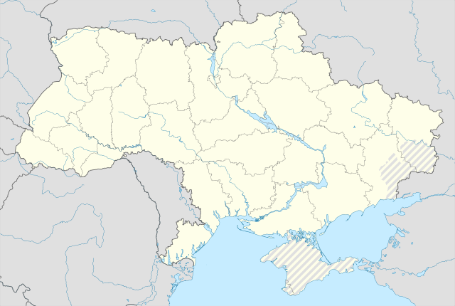
English: Location map of Ukraine under Russian occupation.
Українська: Карта України з зонами російської окупації. |
| Date | |
| Source |
Own work using: Ukraine adm location map improved.svg, according to
|
| Author | Yakiv Gluck |
| Other versions |
|
| SVG development | This map was created with Adobe Illustrator. |


Licensing[edit]
I, the copyright holder of this work, hereby publish it under the following license:
This file is licensed under the Creative Commons Attribution-Share Alike 4.0 International license.
- You are free:
- to share – to copy, distribute and transmit the work
- to remix – to adapt the work
- Under the following conditions:
- attribution – You must give appropriate credit, provide a link to the license, and indicate if changes were made. You may do so in any reasonable manner, but not in any way that suggests the licensor endorses you or your use.
- share alike – If you remix, transform, or build upon the material, you must distribute your contributions under the same or compatible license as the original.
File history
Click on a date/time to view the file as it appeared at that time.
| Date/Time | Thumbnail | Dimensions | User | Comment | |
|---|---|---|---|---|---|
| current | 06:53, 19 June 2023 | | 3,780 × 2,540 (1.8 MB) | Physeters (talk | contribs) | Reverted to version as of 02:11, 12 May 2023 (UTC) revert removed my detail improvements in the Dnieper delta and is no longer accurate |
| 21:48, 18 June 2023 |  | 3,780 × 2,540 (1.54 MB) | Yeagvr (talk | contribs) | Reverted to version as of 17:23, 3 October 2022 (UTC) | |
| 02:11, 12 May 2023 |  | 3,780 × 2,540 (1.8 MB) | Physeters (talk | contribs) | add improved tracing of the Dnieper Delta | |
| 01:30, 4 October 2022 |  | 3,780 × 2,540 (1.36 MB) | Tol (talk | contribs) | Reverted to version as of 17:17, 3 March 2018 (UTC): this substantially changes a file that was not expected to be updated, this file is intentionally different from File:Ukraine under russian occupation.svg | |
| 17:23, 3 October 2022 |  | 3,780 × 2,540 (1.54 MB) | Janitoalevic (talk | contribs) | Updated. | |
| 17:17, 3 March 2018 |  | 3,780 × 2,540 (1.36 MB) | Yakiv Gluck (talk | contribs) | improved using new adm loc map | |
| 01:36, 27 January 2018 |  | 1,546 × 1,038 (457 KB) | Yakiv Gluck (talk | contribs) | {{Information |Description ={{en|Location map of Ukraine under russian occupation.}} {{uk|Карта України з зонами російської окупації.}} |Source =own work, using [[:F... |
You cannot overwrite this file.
File usage
The following 7 pages use this file:
- User:Magog the Ogre/Maps of conflicts/2022 October
- User:Magog the Ogre/Maps of conflicts/2023 June
- User:Magog the Ogre/Maps of conflicts/2023 May
- Commons:Graphic Lab/Illustration workshop/Archive/2024
- File:Ukraine (1991-2014) location map.svg
- File:Ukraine according to Russian claims (2022) location map (1917 highlighted).svg
- File:Ukraine under russian occupation.svg
_location_map.svg)
_location_map_(1917_highlighted).svg)
Global file usage
The following other wikis use this file:
- Usage on bcl.wikipedia.org
- Usage on bn.wikipedia.org
- Usage on en.wikipedia.org
- Chernobyl
- Geography of Ukraine
- Poltava
- Kerch
- Sevastopol
- Tarashcha
- Yalta
- Nestor Makhno
- Sverdlovsk, Ukraine
- Chernivtsi
- Kaniv
- Halych
- Pripyat
- Lutsk
- Drohobych
- Kovel
- Ivano-Frankivsk
- Kalush, Ukraine
- Volodymyr, Volyn Oblast
- Kortelisy
- Starobilsk
- Uzhhorod
- Chernihiv
- Sumy
- Staryi Ostropil
- Kyiv
- Kosivka, Odesa Oblast
- Kosiv
- Shpola
- Mukachevo
- Simferopol
- Irpin
- Khmelnytskyi
- Fastiv
- Boltysh crater
View more global usage of this file.