File:Usaf.e3sentry.750pix.jpg
跳转到导航
跳转到搜索
本预览的尺寸:800 × 515像素。 其他分辨率:320 × 206像素 | 640 × 412像素 | 1,024 × 659像素 | 1,243 × 800像素。
原始文件 (1,243 × 800像素,文件大小:81 KB,MIME类型:image/jpeg)
说明
说明
添加一行文字以描述该文件所表现的内容
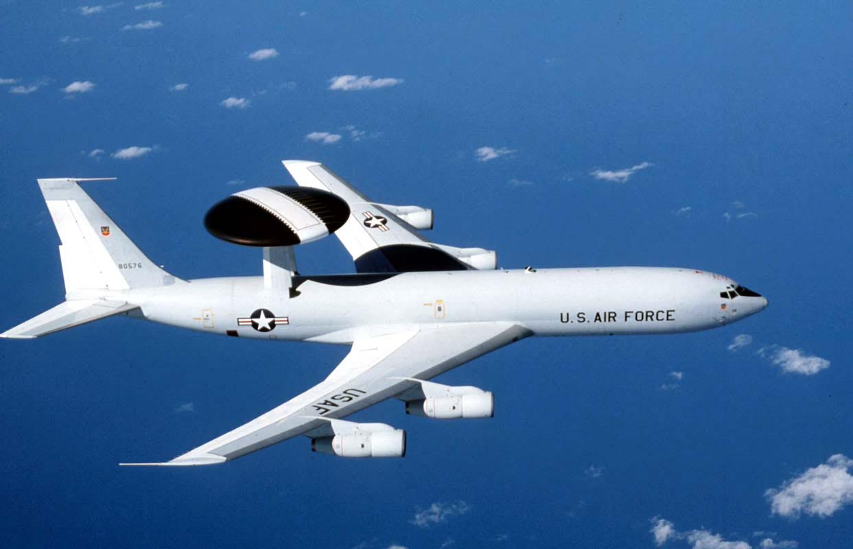
A USAF E-3 Sentry
摘要
[编辑]
| 描述 |
English: The E-3 Sentry is an airborne warning and control system aircraft that provides all-weather surveillance, command, control and communications needed by commanders of U.S. and NATO air defense forces. As proven in Desert Storm, it is the premier air battle command and control aircraft in the world today. The E-3 Sentry is a modified Boeing 707/320 commercial airframe with a rotating radar dome. The dome is 30 feet in diameter, six feet thick, and is held 11 feet above the fuselage by two struts. It contains a radar subsystem that permits surveillance fromthe Earth's surface up into the stratosphere, over land or water. The radar has a range of more than 200 miles for low-flying targets and farther for aerospace vehicles flying at medium to high altitudes. The radar combined with an identification friend or foe subsystem can look down to detect, identify and track enemy and friendly low-flying aircraft by eliminating ground clutter returns that confuse other radar systems. |
| 日期 | |
| 来源 | http://www.af.mil/shared/media/photodb/photos/021107-O-9999G-024.jpg |
| 作者 | U.S. Air Force photo |
许可协议
[编辑]
|
|
 |
文件历史
点击某个日期/时间查看对应时刻的文件。
| 日期/时间 | 缩略图 | 大小 | 用户 | 备注 | |
|---|---|---|---|---|---|
| 当前 | 2007年11月3日 (六) 13:07 | | 1,243 × 800(81 KB) | Denniss(留言 | 贡献) | |
| 2005年12月16日 (五) 11:08 |  | 750 × 483(79 KB) | WonYong~commonswiki(留言 | 贡献) | U.S. Air Force photograph of the E-3 Sentry. By Gary Ell. {{PD-USGov-Military-Air Force}} [http://www.af.mil/photos] |
您不可以覆盖此文件。
文件用途
全域文件用途
以下其他wiki使用此文件:
- ar.wikipedia.org上的用途
- ast.wikipedia.org上的用途
- bn.wikipedia.org上的用途
- bs.wikipedia.org上的用途
- ca.wikipedia.org上的用途
- ckb.wikipedia.org上的用途
- cs.wikipedia.org上的用途
- de.wikipedia.org上的用途
- el.wikipedia.org上的用途
- en.wikipedia.org上的用途
- Gunboat diplomacy
- Boeing Defense, Space & Security
- US–Saudi Arabia AWACS Sale
- User:Bosamar
- User:Sf46
- User:UBX/Military Aviator
- User:The Bushranger
- User:Magus732
- User:Sf46/Gunboat Diplomacy
- User:CnrFallon
- Help talk:Table/Archive 3
- User:Per Ardua Ad Astra
- User:Stars999
- List of AEW&C aircraft operators
- User:Kaiser Taylor
- User:Delta92
- User:Hhfjbaker
- User:Winkelvi
- Wikipedia:Userboxes/United States/Armed Forces
- User:Hilbert Halsay/sandbox
- User:Leobold111/userboxes
- User talk:WASR freak
- User:The Bushranger/Userbox1
查看此文件的更多全域用途。