File:Völkerkarte von Mittel- und Südosteuropa. Italien 1815 bis zur Gegenwart (1905)-es.svg
Ir a la navegación
Ir a la búsqueda

Tamaño de esta previsualización PNG del archivo SVG: 544 × 599 píxeles. Otras resoluciones: 218 × 240 píxeles | 436 × 480 píxeles | 697 × 768 píxeles | 930 × 1024 píxeles | 1859 × 2048 píxeles | 2722 × 2998 píxeles.
Archivo original (archivo SVG, nominalmente 2722 × 2998 píxeles, tamaño de archivo: 1,03 MB)
Leyendas
Leyendas
Añade una explicación corta acerca de lo que representa este archivo
Resumen[editar]
-es.svg&action=edit§ion=1)
| Descripción |
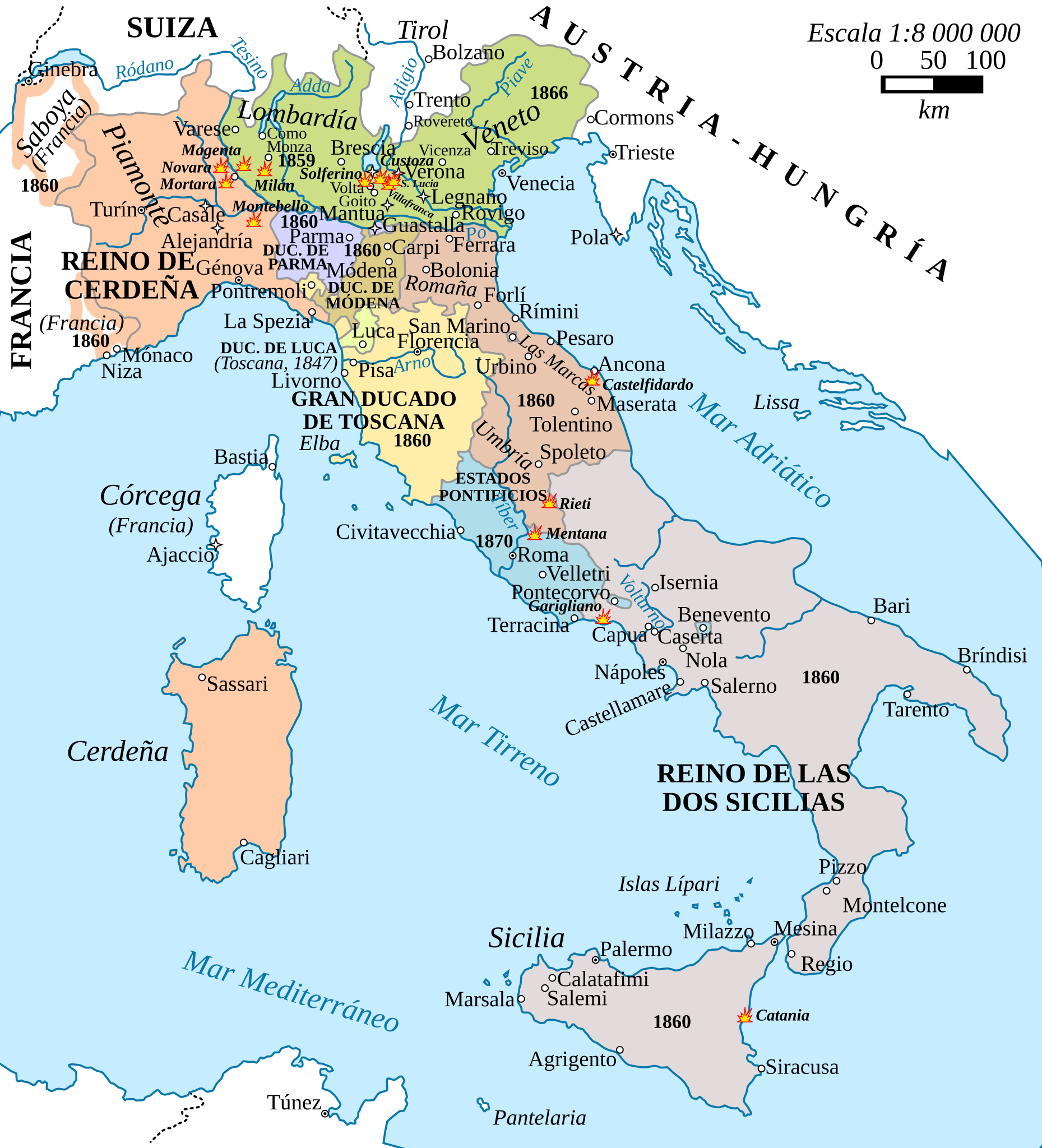
Español: La unificación italiana entre 1815 y 1870. En negrita, el año de anexión al reino de Cerdeña (de Italia a partir de 1861). |
| Fecha | |
| Fuente | File:Völkerkarte_von_Mittel-_und_Südosteuropa._Italien_1815_bis_zur_Gegenwart_(1905).jpg |
| Autor | F. W Putzger (1814--1913) |
.jpg)
Licencia[editar]
-es.svg&action=edit§ion=2)
Este archivo está disponible bajo la licencia Creative Commons Attribution-Share Alike 4.0 International.
- Eres libre:
- de compartir – de copiar, distribuir y transmitir el trabajo
- de remezclar – de adaptar el trabajo
- Bajo las siguientes condiciones:
- atribución – Debes otorgar el crédito correspondiente, proporcionar un enlace a la licencia e indicar si realizaste algún cambio. Puedes hacerlo de cualquier manera razonable pero no de manera que sugiera que el licenciante te respalda a ti o al uso que hagas del trabajo.
- compartir igual – En caso de mezclar, transformar o modificar este trabajo, deberás distribuir el trabajo resultante bajo la misma licencia o una compatible como el original.
Historial del archivo
Haz clic sobre una fecha y hora para ver el archivo tal como apareció en ese momento.
| Fecha y hora | Miniatura | Dimensiones | Usuario | Comentario | |
|---|---|---|---|---|---|
| actual | 09:43 7 mar 2021 | | 2722 × 2998 (1,03 MB) | Rowanwindwhistler (discusión | contribs.) | Uploaded a work by F. W Putzger (1814--1913) from https://commons.wikimedia.org/wiki/File:V%C3%B6lkerkarte_von_Mittel-_und_S%C3%BCdosteuropa._Italien_1815_bis_zur_Gegenwart_(1905).jpg with UploadWizard |
No puedes sobrescribir este archivo.
Usos del archivo
La siguiente página usa este archivo:
Uso global del archivo
Las wikis siguientes utilizan este archivo:
- Uso en en.wikipedia.org
- Uso en es.wikipedia.org
Metadatos
-es.svg&oldid=864363712)
Categorías:
- Spanish-language SVG maps showing history of Europe
- Putzgers Historischer Schul-Atlas
- Maps of Italian Risorgimento
- Maps of the history of the Italian Peninsula
- 1815 in Italy
- 1870
- Kingdom of Sardinia
- Maps of the history of Sardinia
- Maps of the Kingdom of the Two Sicilies
- Maps of the Kingdom of Lombardy-Venetia
- Maps of the Duchy of Parma and Piacenza
- Maps of Duchy of Modena and Reggio
- Maps of the Grand Duchy of Tuscany
- Maps of the Papal States
- Papal States in the 19th century