File:Vaalserberg Hoogtekaart.png

Original file (3,310 × 2,294 pixels, file size: 9.01 MB, MIME type: image/png)
Captions
Captions
Summary
[edit]
| Description |
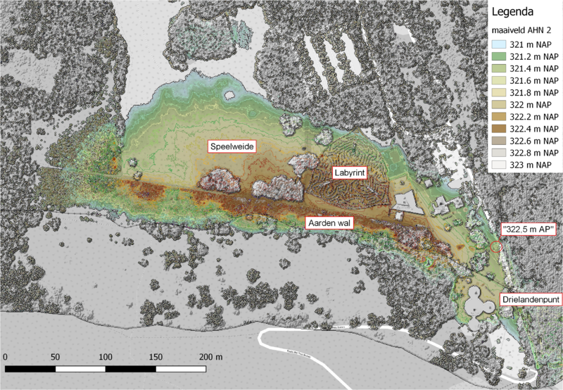
Nederlands: Hoogtekaart van de Vaalserberg met enkele markante plekken
De kop van de dakvormige steen bij het Drielandenpunt is NAP +321,9 meter. Dat is onlangs nagemeten, na twijfels over de vraag wat het hoogste punt van Nederland is. Dat is niet het Drielandenpunt, want in de buurt is een wal opgeworpen van NAP +323,0 m. Ook als deze kunstmatige verhoging buiten beschouwing wordt gelaten, heeft het Drielandenpunt niet het record. Dan komt de eer toe aan een speelweide in de buurt (NAP +322,4 m) bron English: Elevation map of Vaalserberg with annotation in Dutch |
| Date | |
| Source | Own work |
| Author | Hans Erren |
Elevation data from AHN 2
| Description |
This map was created from OpenStreetMap project data, collected by the community. This map may be incomplete, and may contain errors. Don't rely solely on it for navigation. |
|||
| Date | (see file history) | |||
| Source | openstreetmap.org | |||
| Creator |
OpenStreetMap contributors |
|||
| Permission (Reusing this file) |
OpenStreetMap data is available under the Open Database License (details). Map tiles are licensed under the Creative Commons Attribution-ShareAlike 2.0 license (CC-BY-SA 2.0).
This file is licensed under the Creative Commons Attribution-Share Alike 2.0 Generic license.
|
|||
| Georeferencing | If inappropriate please set warp_status = skip to hide. |
Licensing
[edit]
- You are free:
- to share – to copy, distribute and transmit the work
- to remix – to adapt the work
- Under the following conditions:
- attribution – You must give appropriate credit, provide a link to the license, and indicate if changes were made. You may do so in any reasonable manner, but not in any way that suggests the licensor endorses you or your use.
- share alike – If you remix, transform, or build upon the material, you must distribute your contributions under the same or compatible license as the original.
| This work is licensed under the Open Database License (summary). |
"De datasets van het AHN1 en AHN2 zijn beschikbaar als Open Data. Dat betekent dat de data door iedereen gratis en zonder beperkingen te gebruiken is. Zowel de rasterdata als de puntenwolken zijn te downloaden via PDOK en het NationaalGeoregister."
File history
Click on a date/time to view the file as it appeared at that time.
| Date/Time | Thumbnail | Dimensions | User | Comment | |
|---|---|---|---|---|---|
| current | 20:38, 6 August 2016 | | 3,310 × 2,294 (9.01 MB) | Hans Erren (talk | contribs) | User created page with UploadWizard |
You cannot overwrite this file.
File usage on Commons
There are no pages that use this file.
File usage on other wikis
The following other wikis use this file:
- Usage on nl.wikipedia.org