File:Valleyfire oli 2015263 swir.jpg
Jump to navigation
Jump to search
No higher resolution available.
Valleyfire_oli_2015263_swir.jpg (720 × 480 pixels, file size: 490 KB, MIME type: image/jpeg)
Captions
Captions
Add a one-line explanation of what this file represents
Summary
[edit]
| Description |
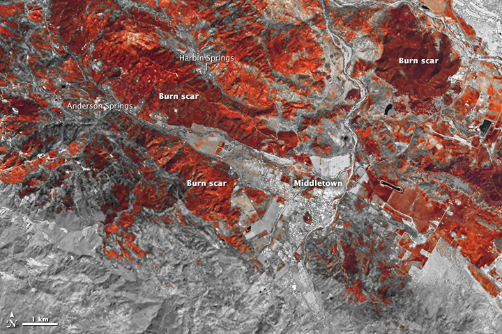
English: False-color view of the charred landscape during the Valley Fire, taken by the Operational Land Imager on Landsat 8 (NASA). Locator map of the Valley Fire, 2015 in northern California from NASA's Earth Observatory : "images from space were taken by infrared cameras on NASA’s Landsat 8 satellite as it passed over Lake County on Monday and capture the magnitude of the 76,067-acre fire. In the pictures, pronounced burn scars appear around Harbin Hot Springs, Cobb and Middletown after the fire moved through on Sept. 12. At least 1,910 structures, including 1,325 homes, were destroyed, making the Valley Fire the third most destructive in California history." |
| Date | |
| Source | http://landsat.visibleearth.nasa.gov/view.php?id=86663 |
| Author | Landsat 8 - OLI |
Licensing
[edit]
| This file is in the public domain in the United States because it was solely created by NASA. NASA copyright policy states that "NASA material is not protected by copyright unless noted". (See Template:PD-USGov, NASA copyright policy page or JPL Image Use Policy.) | ||
 |
Warnings:
|
File history
Click on a date/time to view the file as it appeared at that time.
| Date/Time | Thumbnail | Dimensions | User | Comment | |
|---|---|---|---|---|---|
| current | 17:53, 27 September 2015 | | 720 × 480 (490 KB) | Frank Schulenburg (talk | contribs) | User created page with UploadWizard |
You cannot overwrite this file.
File usage on Commons
There are no pages that use this file.