File:Vancouver de.png
Here nagîvasyonê
Here lêgerînê
Mezinahiya vê pêşdîtinê: 800 × 574 pîksel. Resolusyonên din: 320 × 230 pîksel | 640 × 459 pîksel | 1024 × 735 pîksel | 1280 × 919 pîksel | 1666 × 1196 pîksel.
Dosyeya orjînal (1666 × 1196 pixel, mezinbûnê data: 4,02 MB, MIME-typ: image/png)
Captions
Captions
Add a one-line explanation of what this file represents
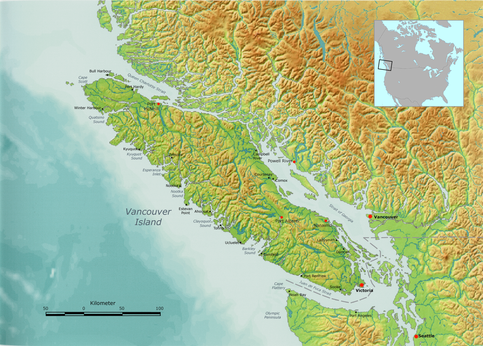
Vancouver Island physical map
| Danasîn | Vancouver Island, as well as the Canada-US border. | ||||
| Dîrok | |||||
| Çavkanî | Own work by Nikater, submitted to the public domain. Background map courtesy of Demis, www.demis.nl. | ||||
| Xwedî | User:Nikater | ||||
| Destûr (Dîsa bikaranînê vê dosyeye) |
|
||||
| Guhartoyên din | Derivative works of this file: Vancouver Island, with Lasqueti Island highlighted.png |
Dîroka daneyê
Ji bo dîtina guhartoya wê demê bişkoka dîrokê bitikîne.
| Dîrok/Katjimêr | Wêneyê biçûk | Mezinahî | Bikarhêner | Şirove | |
|---|---|---|---|---|---|
| niha | 09:29, 6 çiriya pêşîn 2007 | | 1666 x 1196 (4,02 MB) | Nikater (gotûbêj | beşdarî) | {{Information |Description=Vancouver Island |Source=Own work by Nikater, submitted to the public domain. Background map courtesy of Demis, www.demis.nl. |Date=6 October 2007 |Author=User:Nikater |Permission={{PD-Demis}} }} |
Tu nikarî cardin li ser vê dosyeyê binivîsînî.
Bikaranîna pelê
Ev 7 rûpel li jêr vê dosyeyê bi kar tînin:
Bikaranîna gerdûnî ya pelê
Ev wîkiyên di rêzê de vê pelê bi kar tînin:
- Bikaranîna di af.wikipedia.org de
- Bikaranîna di ar.wikipedia.org de
- Bikaranîna di ast.wikipedia.org de
- Bikaranîna di bg.wikipedia.org de
- Bikaranîna di bn.wikipedia.org de
- Bikaranîna di br.wikipedia.org de
- Bikaranîna di ca.wikipedia.org de
- Bikaranîna di cs.wikipedia.org de
- Bikaranîna di da.wikipedia.org de
- Bikaranîna di de.wikipedia.org de
- Bikaranîna di en.wikipedia.org de
- Bikaranîna di eo.wikipedia.org de
- Bikaranîna di es.wikipedia.org de
- Isla de Vancouver
- Estrecho de Juan de Fuca
- Islas del Golfo
- Islas San Juan
- Estrecho de Haro
- Expedición Vancouver
- Islas Discovery
- Estrecho de Johnstone
- José María Narváez
- Estrecho Rosario
- Pasaje Discovery
- Bute Inlet
- Knight Inlet
- Estrecho de la Reina Carlota
- Toba Inlet
- Barkley Sound
- Canal Cordero
- Archipiélago Broughton
- Mar de los Salish
- Bikaranîna di fi.wikipedia.org de
- Bikaranîna di fy.wikipedia.org de
- Bikaranîna di gl.wikipedia.org de
- Bikaranîna di hr.wikipedia.org de
- Bikaranîna di hu.wikipedia.org de
Zêdetir bikaranîna global a vê pelê bibîne.