File:Vassal states of the Ottoman Empire in 1683-es.svg
Ir a la navegación
Ir a la búsqueda

Tamaño de esta previsualización PNG del archivo SVG: 767 × 600 píxeles. Otras resoluciones: 307 × 240 píxeles | 614 × 480 píxeles | 982 × 768 píxeles | 1280 × 1001 píxeles | 2560 × 2002 píxeles | 2557 × 2000 píxeles.
Archivo original (archivo SVG, nominalmente 2557 × 2000 píxeles, tamaño de archivo: 1,11 MB)
Leyendas
Leyendas
Añade una explicación corta acerca de lo que representa este archivo
Resumen[editar]
| Descripción |
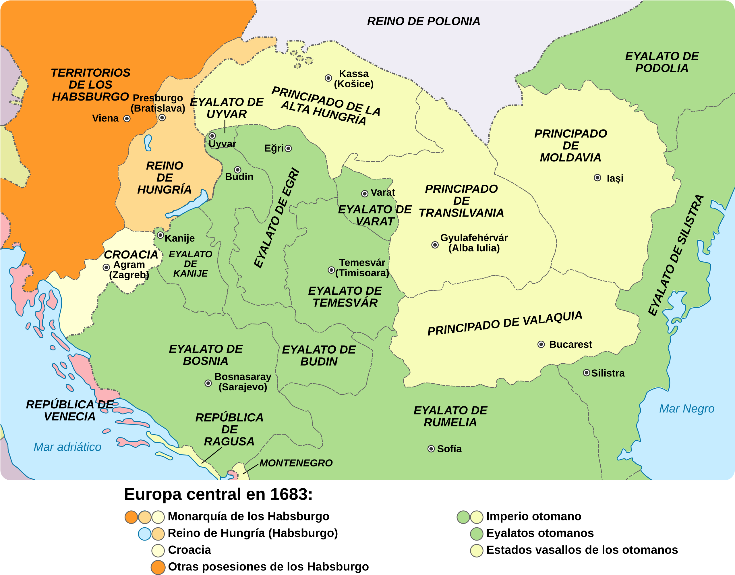
English: Central Europe in 1683 - Habsburg and Ottoman territories, including Habsburg Kingdom of Hungary (Royal Hungary) and Habsburg Croatia, Ottoman vassal states and Ottoman eyalets. Español: Europa central en 1683: los territorios de los Habsburgo y los otomanos, incluyendo el Reino de Hungría, la Croacia de los Habsburgo, los Estados vasallos de los otomanos y los eyalatos. |
| Fecha | |
| Fuente | |
| Autor |
|
| Otras versiones |
|
.svg)


Licencia[editar]
Yo, el titular de los derechos de autor de esta obra, la publico en los términos de la siguiente licencia:
Este archivo se encuentra bajo la licencia Creative Commons Genérica de Atribución/Compartir-Igual 3.0.
- Eres libre:
- de compartir – de copiar, distribuir y transmitir el trabajo
- de remezclar – de adaptar el trabajo
- Bajo las siguientes condiciones:
- atribución – Debes otorgar el crédito correspondiente, proporcionar un enlace a la licencia e indicar si realizaste algún cambio. Puedes hacerlo de cualquier manera razonable pero no de manera que sugiera que el licenciante te respalda a ti o al uso que hagas del trabajo.
- compartir igual – En caso de mezclar, transformar o modificar este trabajo, deberás distribuir el trabajo resultante bajo la misma licencia o una compatible como el original.
Historial del archivo
Haz clic sobre una fecha y hora para ver el archivo tal como apareció en ese momento.
| Fecha y hora | Miniatura | Dimensiones | Usuario | Comentario | |
|---|---|---|---|---|---|
| actual | 11:16 30 ago 2017 | | 2557 × 2000 (1,11 MB) | Rowanwindwhistler (discusión | contribs.) | New colours. http://colorbrewer2.org/#type=sequential&scheme=RdPu&n=5 Larger |
| 08:00 1 oct 2016 |  | 877 × 688 (1,01 MB) | Rowanwindwhistler (discusión | contribs.) | Real text hidden | |
| 22:09 29 mar 2014 |  | 877 × 688 (396 kB) | Rowanwindwhistler (discusión | contribs.) | User created page with UploadWizard |
No puedes sobrescribir este archivo.
Usos del archivo
Las siguientes páginas usan este archivo:
Uso global del archivo
Las wikis siguientes utilizan este archivo:
- Uso en ar.wikipedia.org
- Uso en arz.wikipedia.org
- Uso en ast.wikipedia.org
- Uso en ca.wikipedia.org
- Uso en es.wikipedia.org
- Uso en eu.wikipedia.org
- Uso en gl.wikipedia.org
- Uso en pt.wikipedia.org
- Uso en www.wikidata.org
Metadatos
Categorías:
- Spanish-language SVG maps showing history of Europe
- Maps of the history of Central Europe
- Maps of the Habsburg Monarchy
- Maps of eyalets of the Ottoman Empire
- Maps of vassal states of the Ottoman Empire
- Maps of the history of the Ottoman Empire in the 1680s
- Maps of the history of Hungary (1526–1700)
- Maps of the history of Slovakia
- Maps of the history of Croatia (1526–1918)
- Maps of the history of Bosnia and Herzegovina under Ottoman Empire
- Maps of the Ottoman period in the history of Serbia
- Maps of the history of Vojvodina
- Maps of the history of Banat
- Maps of the history of Early Modern Romania
- Maps of the history of Transylvania
- Maps of the history of Moldova
- Kingdom of Hungary (1526–1867)
- Principality of Upper Hungary
- Eyalet of Bosnia
- Budin Province, Ottoman Empire
- Kanije Province, Ottoman Empire
- Eğri Province, Ottoman Empire
- Maps of Temeşvar Province, Ottoman Empire
- Varat Province, Ottoman Empire
- Uyvar Province, Ottoman Empire
- Principality of Transylvania
- Maps of Wallachia