File:Vassal states of the Ottoman Empire in 1683-es.svg
Перейти к навигации
Перейти к поиску

Размер этого PNG-превью для исходного SVG-файла: 767 × 600 пкс. Другие разрешения: 307 × 240 пкс | 614 × 480 пкс | 982 × 768 пкс | 1280 × 1001 пкс | 2560 × 2002 пкс | 2557 × 2000 пкс.
Исходный файл (SVG-файл, номинально 2557 × 2000 пкс, размер файла: 1,11 МБ)
Краткие подписи
Краткие подписи
Добавьте однострочное описание того, что собой представляет этот файл
Краткое описание
[править]| Описание |
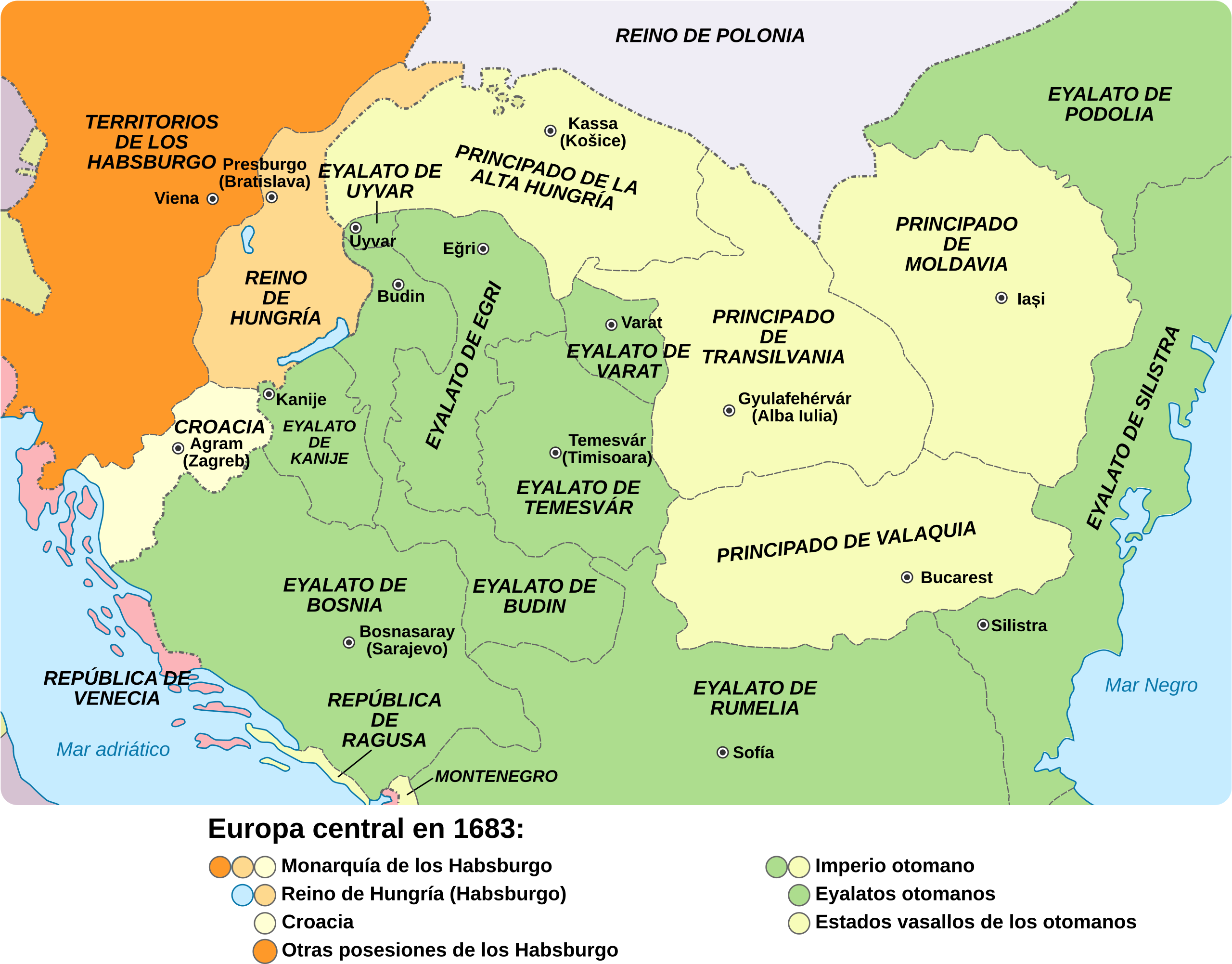
English: Central Europe in 1683 - Habsburg and Ottoman territories, including Habsburg Kingdom of Hungary (Royal Hungary) and Habsburg Croatia, Ottoman vassal states and Ottoman eyalets. Español: Europa central en 1683: los territorios de los Habsburgo y los otomanos, incluyendo el Reino de Hungría, la Croacia de los Habsburgo, los Estados vasallos de los otomanos y los eyalatos. |
| Дата | |
| Источник | |
| Автор |
|
| Другие версии |
|
.svg)


Лицензирование
[править]
Я, владелец авторских прав на это произведение, добровольно публикую его на условиях следующей лицензии:
Этот файл доступен по лицензии Creative Commons Attribution-Share Alike 3.0 Unported.
- Вы можете свободно:
- делиться произведением – копировать, распространять и передавать данное произведение
- создавать производные – переделывать данное произведение
- При соблюдении следующих условий:
- атрибуция – Вы должны указать авторство, предоставить ссылку на лицензию и указать, внёс ли автор какие-либо изменения. Это можно сделать любым разумным способом, но не создавая впечатление, что лицензиат поддерживает вас или использование вами данного произведения.
- распространение на тех же условиях – Если вы изменяете, преобразуете или создаёте иное произведение на основе данного, то обязаны использовать лицензию исходного произведения или лицензию, совместимую с исходной.
История файла
Нажмите на дату/время, чтобы увидеть версию файла от того времени.
| Дата/время | Миниатюра | Размеры | Участник | Примечание | |
|---|---|---|---|---|---|
| текущий | 11:16, 30 августа 2017 | | 2557 × 2000 (1,11 МБ) | Rowanwindwhistler (обсуждение | вклад) | New colours. http://colorbrewer2.org/#type=sequential&scheme=RdPu&n=5 Larger |
| 08:00, 1 октября 2016 |  | 877 × 688 (1,01 МБ) | Rowanwindwhistler (обсуждение | вклад) | Real text hidden | |
| 22:09, 29 марта 2014 |  | 877 × 688 (396 КБ) | Rowanwindwhistler (обсуждение | вклад) | User created page with UploadWizard |
Вы не можете перезаписать этот файл.
Использование файла
Следующие 5 страниц используют этот файл:
Глобальное использование файла
Данный файл используется в следующих вики:
- Использование в ar.wikipedia.org
- Использование в arz.wikipedia.org
- Использование в ast.wikipedia.org
- Использование в ca.wikipedia.org
- Использование в es.wikipedia.org
- Использование в eu.wikipedia.org
- Использование в gl.wikipedia.org
- Использование в pt.wikipedia.org
- Использование в www.wikidata.org
Метаданные
Категории:
- Spanish-language SVG maps showing history of Europe
- Maps of the history of Central Europe
- Maps of the Habsburg Monarchy
- Maps of eyalets of the Ottoman Empire
- Maps of vassal states of the Ottoman Empire
- Maps of the history of the Ottoman Empire in the 1680s
- Maps of the history of Hungary (1526–1700)
- Maps of the history of Slovakia
- Maps of the history of Croatia (1526–1918)
- Maps of the history of Bosnia and Herzegovina under Ottoman Empire
- Maps of the Ottoman period in the history of Serbia
- Maps of the history of Vojvodina
- Maps of the history of Banat
- Maps of the history of Early Modern Romania
- Maps of the history of Transylvania
- Maps of the history of Moldova
- Kingdom of Hungary (1526–1867)
- Principality of Upper Hungary
- Eyalet of Bosnia
- Budin Province, Ottoman Empire
- Kanije Province, Ottoman Empire
- Eğri Province, Ottoman Empire
- Maps of Temeşvar Province, Ottoman Empire
- Varat Province, Ottoman Empire
- Uyvar Province, Ottoman Empire
- Principality of Transylvania
- Maps of Wallachia