File:Vegetation.png
跳去導覽
跳去搵嘢

預覽大細:800 × 359 像素。 第啲解像度:320 × 144 像素 | 640 × 287 像素 | 1,385 × 622 像素。
原本檔案 (1,385 × 622 像素,檔案大細:85 KB ,MIME類型:image/png)
Captions
Captions
Add a one-line explanation of what this file represents
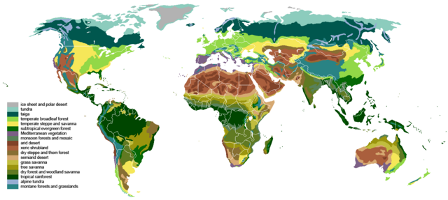
One way of mapping terrestrial biomes around the world
摘要[編輯]
| 描述 | The main biomes in the world. Drawn by hand using maps. |
| 日期 | |
| 來源 |
The blank world map in Commons and WSOY Iso karttakirja for the information. Referred to over a hundred sources, but here are some of the more extensively used ones: [1], [2], [3], [4], [5], [6], [7], [8], [9], [10] |
| 作者 | Ville Koistinen (user Vzb83) |
| Other versions |
Derivative works of this file: |
![[5]](https://www.surfaceview.co.uk/storage/image/VMA0018.jpg)
![[6]](https://upload.wikimedia.org/wikipedia/commons/4/4f/Vegetationszonen.png)
![[7]](https://esdac.jrc.ec.europa.eu/images/Eudasm/Africa/images/maps/download/afr_veg.jpg)
![[8]](https://www.researchgate.net/profile/Julie-Morin-9/publication/319979374/figure/fig2/AS:614404802478081@1523496928789/UNESCO-AETFAT-UNSO-Whites-vegetation-map-of-Africa-The-Guineo-Congolian-regional.png)
![[9]](https://www.researchgate.net/profile/Andrea-Kay/publication/276452894/figure/fig1/AS:623557285523457@1525679050775/Map-of-study-area-showing-modern-potential-natural-vegetation-simplified-from-White.png)
![[10]](https://i.pinimg.com/originals/5d/b3/b5/5db3b5b71e47b5467d8df815cd525df5.png)

|
This biogeographical map image could be recreated using vector graphics as an SVG file. This has several advantages; see Commons:Media for cleanup for more information. If an SVG form of this image is already available, please upload it. After uploading an SVG, replace this template with {{vector version available|new image name.svg}}.
|
協議[編輯]
I, the copyright holder of this work, hereby publish it under the following licenses:

|
根據自由軟體基金會發佈嘅無固定段落、封面文字同封底文字GNU自由文件授權條款第1.2或打後嘅版本,你獲授權可以重製、散佈同埋修改爾份文件。授權條款嘅副本喺章節GNU自由文件授權條款。 |
| 呢個檔案用共享創意 姓名標示-非商業性-相同方式分享3.0 未本地化版本條款授權。 | ||
| ||
| This licensing tag was added to this file as part of the GFDL licensing update. |
This file is licensed under the Creative Commons Attribution-Share Alike 2.5 Generic, 2.0 Generic and 1.0 Generic license.
- 你可以:
- 去分享 – 複製、發佈同傳播呢個作品
- 再改 – 創作演繹作品
- 要遵照下面嘅條件:
- 署名 – 你一定要畀合適嘅表彰、畀返指向呢個授權條款嘅連結,同埋寫明有無改過嚟。你可以用任何合理方式去做,但唔可以用任何方式暗示授權人認可咗你或者你嘅使用方式。
- 相同方式分享 – 如果你用任何方式改過呢個作品,你必須要用返原本或者相似嘅條款發佈。
你可以揀你想用嘅牌照。
檔案歷史
撳個日期/時間去睇響嗰個時間出現過嘅檔案。
| 日期/時間 | 縮圖 | 尺寸 | 用戶 | 註解 | |
|---|---|---|---|---|---|
| 現時 | 2024年3月24號 (日) 18:55 | | 1,385 × 622(85 KB) | Berkserker(傾偈 | 貢獻) | Added more level of detail, particularly to montane and arid regions. Corrections to savannas. |
| 2023年9月18號 (一) 21:44 |  | 1,385 × 622(81 KB) | Berkserker(傾偈 | 貢獻) | Minor correction to key | |
| 2023年9月18號 (一) 21:01 |  | 1,385 × 622(80 KB) | Berkserker(傾偈 | 貢獻) | Slight correction to Eastern Australia | |
| 2020年8月11號 (二) 09:37 |  | 1,385 × 622(80 KB) | Berkserker(傾偈 | 貢獻) | Corrections to Madagascar | |
| 2020年8月6號 (四) 18:35 |  | 1,385 × 622(80 KB) | Berkserker(傾偈 | 貢獻) | Minor optimization according to Dyer 2006 | |
| 2020年8月5號 (三) 07:01 |  | 1,385 × 622(80 KB) | Berkserker(傾偈 | 貢獻) | Added a third source: Dyer 2006, specifically to address the issues in Eastern USA | |
| 2020年6月15號 (一) 03:40 |  | 1,385 × 622(80 KB) | Berkserker(傾偈 | 貢獻) | More corrections as well as fixing remaining dead pixels | |
| 2020年6月9號 (二) 13:22 |  | 1,385 × 622(80 KB) | Berkserker(傾偈 | 貢獻) | Further corrections based on the same sources | |
| 2020年3月21號 (六) 07:20 |  | 1,385 × 622(80 KB) | Berkserker(傾偈 | 貢獻) | Minor correction to Andean montane forests | |
| 2020年3月21號 (六) 07:09 |  | 1,385 × 622(80 KB) | Berkserker(傾偈 | 貢獻) | Fixed key and map colors not matching |
你無得衾咗個檔案。
檔案用途
以下嘅4版用到呢個檔:
全域檔案使用情況
下面嘅維基都用緊呢個檔案:
- bh.wikipedia.org嘅使用情況
- bn.wikipedia.org嘅使用情況
- bs.wikipedia.org嘅使用情況
- ckb.wikipedia.org嘅使用情況
- cs.wikipedia.org嘅使用情況
- el.wikipedia.org嘅使用情況
- en.wikipedia.org嘅使用情況
- en.wikibooks.org嘅使用情況
- et.wikipedia.org嘅使用情況
- eu.wikipedia.org嘅使用情況
- fa.wikipedia.org嘅使用情況
- fr.wikipedia.org嘅使用情況
- hi.wikibooks.org嘅使用情況
- ik.wikipedia.org嘅使用情況
- ku.wikipedia.org嘅使用情況
- mk.wikipedia.org嘅使用情況
- mt.wikipedia.org嘅使用情況
- no.wikipedia.org嘅使用情況
- oc.wikipedia.org嘅使用情況
- om.wikipedia.org嘅使用情況
- pnb.wikipedia.org嘅使用情況
- ps.wikipedia.org嘅使用情況
- pt.wikipedia.org嘅使用情況
- si.wikipedia.org嘅使用情況
- ta.wikipedia.org嘅使用情況
- th.wikipedia.org嘅使用情況
- tr.wikipedia.org嘅使用情況
- ur.wikipedia.org嘅使用情況
- vi.wikipedia.org嘅使用情況
- vls.wikipedia.org嘅使用情況
- war.wikipedia.org嘅使用情況
- www.wikidata.org嘅使用情況
- zh-yue.wikipedia.org嘅使用情況
- zh.wikipedia.org嘅使用情況