File:Verteilung von Büttel-Orten in Deutschland.png
Jump to navigation
Jump to search

Size of this preview: 432 × 599 pixels. Other resolutions: 173 × 240 pixels | 346 × 480 pixels | 865 × 1,200 pixels.
Original file (865 × 1,200 pixels, file size: 257 KB, MIME type: image/png)
Captions
Captions
Add a one-line explanation of what this file represents
Summary
[edit]
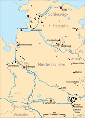
| Description | Verteilung von Büttel-Orten in Norddeutschland |
| Date | |
| Source | Own work |
| Author | Lencer |

|
This map has been made or improved in the German Kartenwerkstatt (Map Lab). You can propose maps to improve as well.
|

|
File:Verteilung von Büttel-Orten in Deutschland.svg is a vector version of this file. It should be used in place of this PNG file when not inferior.
File:Verteilung von Büttel-Orten in Deutschland.png → File:Verteilung von Büttel-Orten in Deutschland.svg
For more information, see Help:SVG. |
 |
Licensing
[edit]
The map has been created with the Generic Mapping Tools: https://www.generic-mapping-tools.org/ using one or more of these public-domain datasets for the relief:
|

|
Permission is granted to copy, distribute and/or modify this document under the terms of the GNU Free Documentation License, Version 1.2 or any later version published by the Free Software Foundation; with no Invariant Sections, no Front-Cover Texts, and no Back-Cover Texts. A copy of the license is included in the section entitled GNU Free Documentation License. |
| This file is licensed under the Creative Commons Attribution-Share Alike 3.0 Unported license. | ||
| ||
| This licensing tag was added to this file as part of the GFDL licensing update. |
File history
Click on a date/time to view the file as it appeared at that time.
| Date/Time | Thumbnail | Dimensions | User | Comment | |
|---|---|---|---|---|---|
| current | 19:01, 21 April 2007 | | 865 × 1,200 (257 KB) | Lencer (talk | contribs) | {{Information |Description= |Source= |Date= |Author= }} |
| 19:45, 17 April 2007 |  | 865 × 1,200 (286 KB) | Lencer (talk | contribs) | ||
| 18:45, 14 April 2007 |  | 917 × 1,200 (140 KB) | Lencer (talk | contribs) | ||
| 18:27, 14 April 2007 |  | 1,799 × 2,355 (152 KB) | Lencer (talk | contribs) | {{Information |Description= Verteilung von Büttel-Orten in Norddeutschland |Source="own work" |Date=April 2007 |Author=Lencer }} {{Kartenwerkstatt}} == Licensing == {{GFDL-GMT}} |
You cannot overwrite this file.
File usage on Commons
The following page uses this file:
File usage on other wikis
The following other wikis use this file:
- Usage on de.wikipedia.org