File:Vertrag von Verdun.svg
Jump to navigation
Jump to search

Size of this PNG preview of this SVG file: 600 × 600 pixels. Other resolutions: 240 × 240 pixels | 480 × 480 pixels | 768 × 768 pixels | 1,024 × 1,024 pixels | 2,048 × 2,048 pixels | 890 × 890 pixels.
Original file (SVG file, nominally 890 × 890 pixels, file size: 679 KB)
Captions
Captions
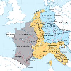
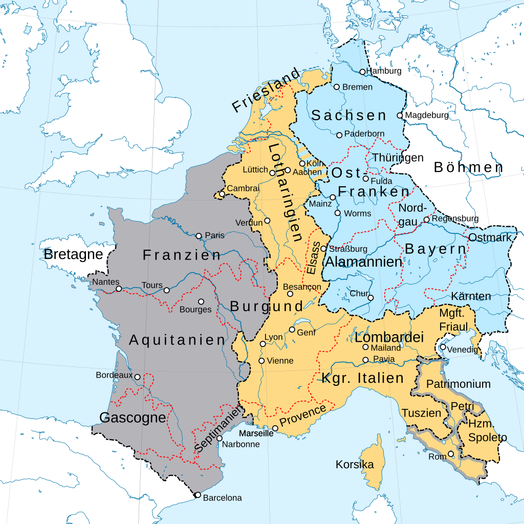
Partition of Francia after the Treaty of Verdun 843
Summary
[edit]| Description |
Deutsch: Fränkische Reichsteilung nach dem Vertrag von Verdun 843.
English: Partition of Francia after the Treaty of Verdun 843.
Français : Partition de la Francia après le traité de Verdun 843
Русский: Раздел Каролингской империи по Верденскому договору 843 года
|
||
| Date | |||
| Source | This vector image includes elements that have been taken or adapted from this file: |
||
| Author | Furfur | ||
| Permission (Reusing this file) |
I, the copyright holder of this work, hereby publish it under the following licenses:
This file is licensed under the Creative Commons Attribution-Share Alike 4.0 International license.
You may select the license of your choice. |
||
| Other versions |
|
||
| SVG development | This map was created with Adobe Illustrator. |


File history
Click on a date/time to view the file as it appeared at that time.
| Date/Time | Thumbnail | Dimensions | User | Comment | |
|---|---|---|---|---|---|
| current | 11:58, 11 August 2019 | | 890 × 890 (679 KB) | Furfur (talk | contribs) | Kosmetik2 (Grenzlinien dünner) |
| 21:25, 10 August 2019 |  | 890 × 890 (681 KB) | Furfur (talk | contribs) | Kosmetik | |
| 19:25, 10 August 2019 |  | 890 × 890 (712 KB) | Furfur (talk | contribs) | == {{int:filedesc}} == {{Information |Description={{User:Medium69/Traduction}} {{de|1=Fränkische Reichsteilung nach dem Vertrag von Verdun 843.}} |Source={{AttribSVG|1=Fond de carte Tour de France-blank.svg|2=Sémhur}} |Date=2019-08-10 |Author={{U|Furfur}} |Permission={{self|GFDL|cc-by-sa-4.0}} |Other versions= |Other fields={{Igen|A|+|%|s=m}} }} Category:SVG maps showing history in German |
You cannot overwrite this file.
File usage on Commons
The following 8 pages use this file:
File usage on other wikis
The following other wikis use this file:
- Usage on de.wikipedia.org
- Fränkisches Reich
- Geschichte Deutschlands
- Heiliges Römisches Reich
- 10. August
- 9. Jahrhundert
- 865
- 843
- Lotharii Regnum
- Ostfrankenreich
- Geschichte Bayerns
- Vertrag von Verdun
- Ludwig der Deutsche
- Fränkische Reichsteilung
- Burgund (fränkisches Teilreich)
- Geschichte des Saarlandes
- Westfrankenreich
- Deutschland
- Geschichte des Landes Salzburg
- Diskussion:Valenciennes
- Innerdynastische Kämpfe der Karolinger 830–842
- Die Schweiz im Mittelalter
- Obermettingen
- Geschichte Frankreichs
- Herzogtum Lothringen
- Kölngau
- Karl der Kahle
- Benutzer Diskussion:Furfur/Archiv/1
- Benutzer:GerhardSchuhmacher/Alamannen(1)
- Supponiden
- Burg Zeltingen
- Französische Münzgeschichte
- Usage on de.wikibooks.org
- Usage on en.wikipedia.org
- Usage on eo.wikipedia.org
- Karolo la Granda
- Karolidoj
- Karlo la 2-a (Francio)
- Karlo la 3-a (Francio)
- Rodolfo (Francio)
- Lotaro (Francio)
- Karlo la 3-a la Dika
- Karolo Martelo
- Ludoviko la 2-a (Francio)
- Ludoviko la 3-a (Francio)
- Karlomano la 2-a
- Roberto la 1-a (Francio)
- Ludoviko la 4-a (Francio)
- Ludoviko la 5-a (Francio)
- Pipino la pli juna
View more global usage of this file.