File:Vestingplattegrond van Veere Der Veer (titel op object), RP-P-AO-15-70B-1.jpg
Jump to navigation
Jump to search

Size of this preview: 507 × 599 pixels. Other resolutions: 203 × 240 pixels | 406 × 480 pixels | 650 × 768 pixels | 867 × 1,024 pixels | 1,733 × 2,048 pixels | 2,964 × 3,502 pixels.
Original file (2,964 × 3,502 pixels, file size: 1.57 MB, MIME type: image/jpeg)
Captions
Captions
Add a one-line explanation of what this file represents
Summary
[edit],_RP-P-AO-15-70B-1.jpg&action=edit§ion=1)
| Description |
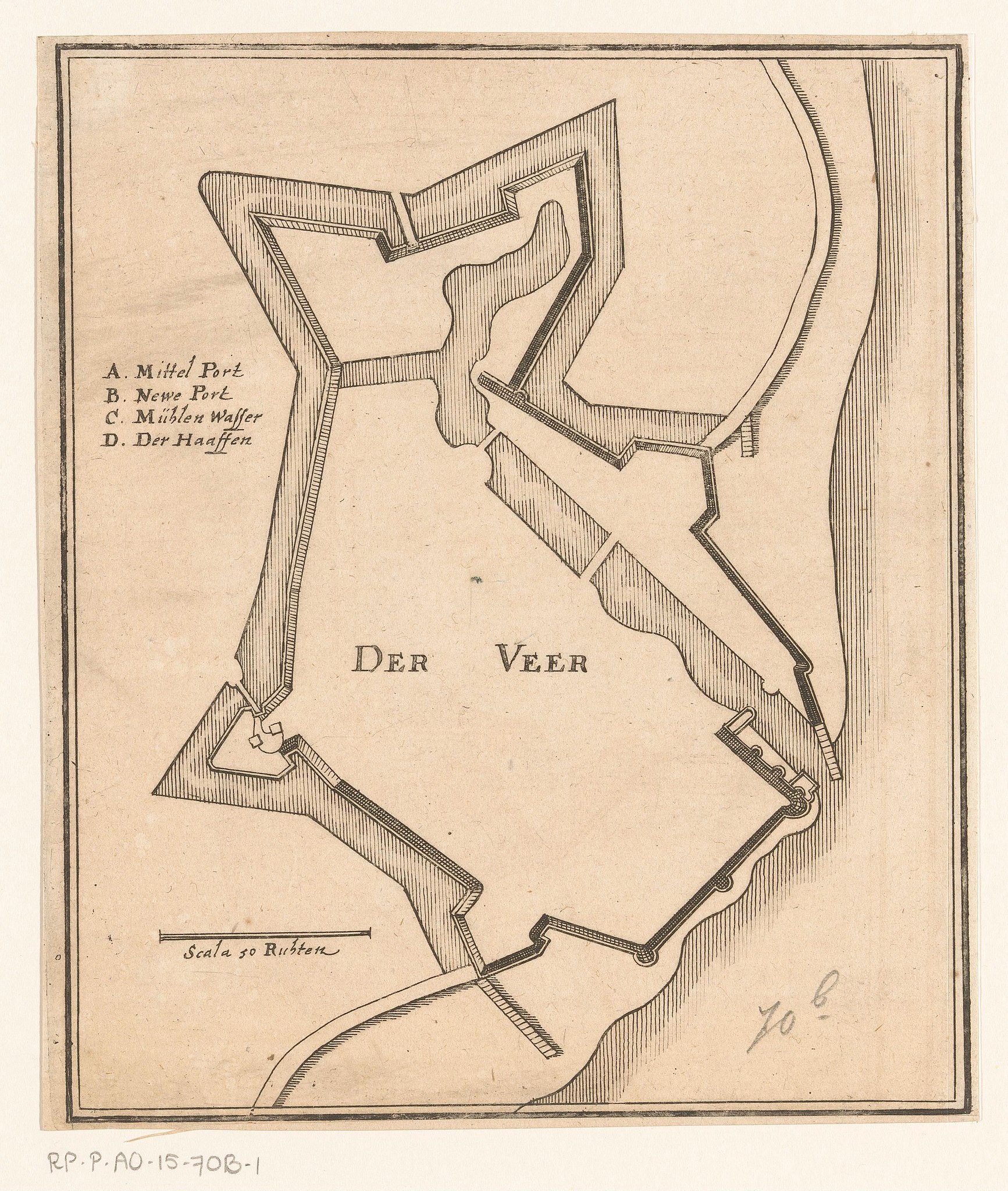
Nederlands: Identificatie Titel(s): Vestingplattegrond van Veere. Der Veer (titel op object) Objecttype: prent plattegrond Objectnummer: RP-P-AO-15-70. B-1 Catalogusreferentie: Wüthrich (Merian) NLB 110 Omschrijving: Links een Duitse legenda A-D. Linksonder een schaalstok: Scala 50 Ruhten. Vervaardiging Vervaardiger: prentmaker: Caspar Merian, naar ontwerp van: Johann Merck, uitgever: Caspar Merian Plaats vervaardiging: Frankfurt am Main Datering: 1654 - ca. 1700 Materiaal: papier Techniek: etsen Afmetingen: blad: h 180 mm (boven binnen plaatrand afgesneden), plaatrand: b 153 mm Toelichting Prent gebruikt in: Zeiller, Martin. M.Z. Topographia Circuli Burgundici Oder Beschreibung une Eigentliche Abbildung der Vornehmsten Örter in dem Hochlöblichen Burgund- un Niderlandischen Crayse. Frankfurt am Main: Caspar Merian, 1654. Of in: Zeiller, Martin. M. Z. Topographia Germaniae-Inferioris vel Circuli-Burgundici, das ist Beschreibung (…). Frankfurt am Main: Caspar Merian, 1659. Of in een van de twee latere uitgaven van deze publicatie die, hoewel het jaar 1659 erin staat vermeld als jaar van uitgave, zijn uitgegeven in respectievelijk ca. 1670 en ca. 1700. Onderwerp Wat: maps of cities, fortified city, coat of arms (as symbol of the state, etc.) (+ province; provincial), coat of arms (as symbol of the state, city, municipal) Waar: Veere Verwerving en rechten Verwerving: overdracht van beheer 1887 Copyright: Publiek domein |
| Date | - ca. 1700 |
| Source | http://hdl.handle.net/10934/RM0001.COLLECT.667990 |
| Author | Rijksmuseum |
Licensing
[edit],_RP-P-AO-15-70B-1.jpg&action=edit§ion=2)
| This file is made available under the Creative Commons CC0 1.0 Universal Public Domain Dedication. | |
| The person who associated a work with this deed has dedicated the work to the public domain by waiving all of their rights to the work worldwide under copyright law, including all related and neighboring rights, to the extent allowed by law. You can copy, modify, distribute and perform the work, even for commercial purposes, all without asking permission.
|
File history
Click on a date/time to view the file as it appeared at that time.
| Date/Time | Thumbnail | Dimensions | User | Comment | |
|---|---|---|---|---|---|
| current | 12:59, 2 January 2020 | | 2,964 × 3,502 (1.57 MB) | Mr.Nostalgic (talk | contribs) | == {{int:filedesc}} == {{Information |Description={{nl|1=<br><br><big>'''Identificatie'''</big><br>'''Titel(s): '''Vestingplattegrond van VeereDer Veer (titel op object)<br>'''Objecttype:''' prent plattegrond <br>'''Objectnummer:''' RP-P-AO-15-70B-1<br>'''Catalogusreferentie:''' Wüthrich (Merian) NLB 110<br>'''Omschrijving:''' Links een Duitse legenda A-D. Linksonder een schaalstok: Scala 50 Ruhten.<br><br><big>'''Vervaardiging'''</big><br>'''Vervaardiger:''' prentmaker: Caspar Meriannaar ont... |
You cannot overwrite this file.
File usage on Commons
There are no pages that use this file.
,_RP-P-AO-15-70B-1.jpg&oldid=841957716)