File:Viipurin asemakaava. Andreas Streng, Oxehufwud, O. A. 1630s.tif
Jump to navigation
Jump to search

Size of this JPG preview of this TIF file: 800 × 565 pixels. Other resolutions: 320 × 226 pixels | 640 × 452 pixels | 1,024 × 723 pixels | 1,280 × 904 pixels | 2,560 × 1,807 pixels | 3,543 × 2,501 pixels.
Original file (3,543 × 2,501 pixels, file size: 25.37 MB, MIME type: image/tiff)
Captions
Captions
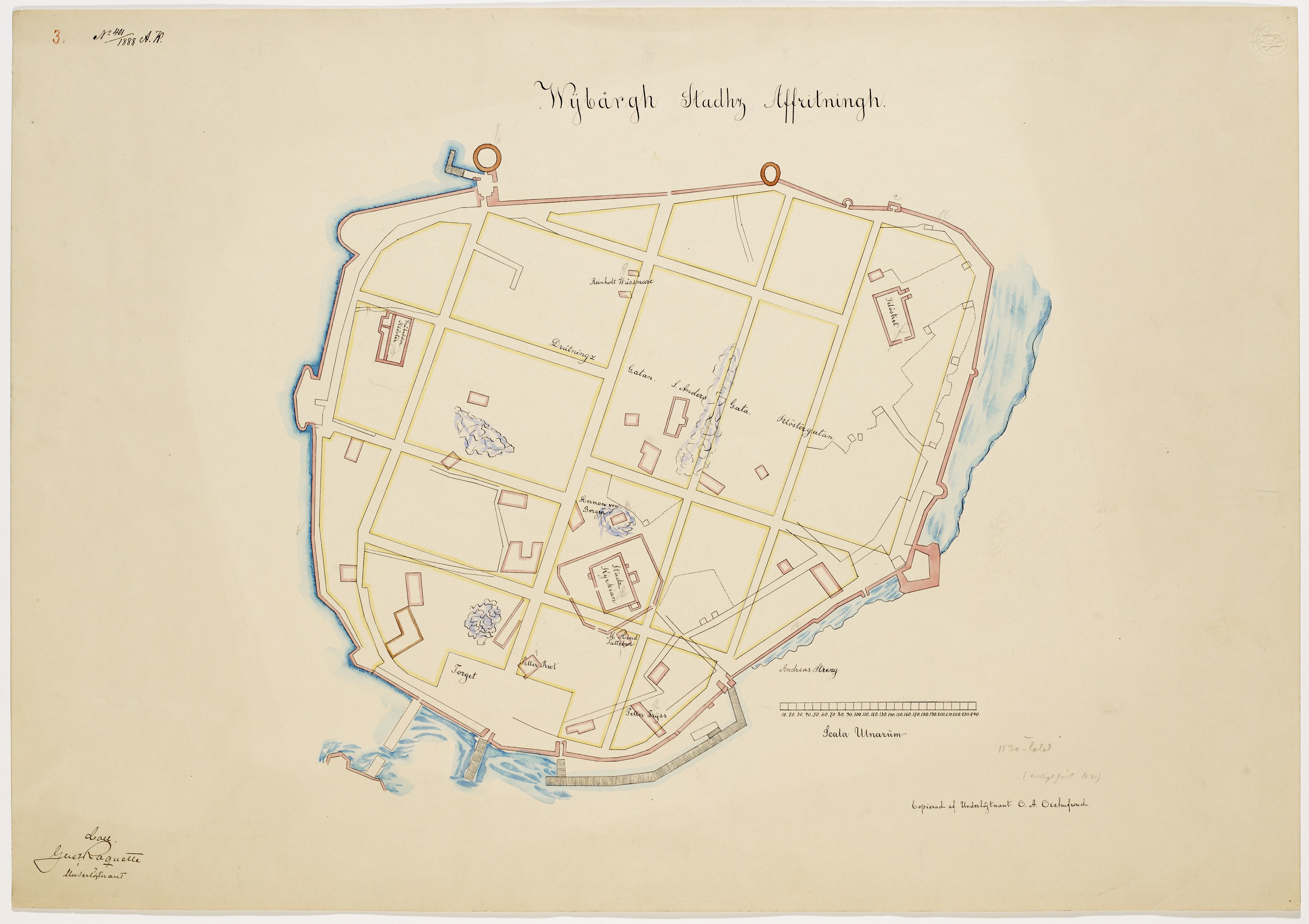
Map of Vyborg, 1630s
Summary[edit]
| Description |
Русский: Карта Выборга, 1630-е. Автор Андреас Стренг. Копия 1888 года, изготовлена Oxehufwud, O. A..
English: Map of Vyborg, 1630s. Created by Andreas Streng. Copy of 1888 by Oxehufwud, O. A.. |
| Date | |
| Source | https://www.finna.fi/Record/museovirasto.AE4943C39742AA172DF57B23098F3FFE?lng=en-gb |
| Author | Oxehufwud, O. A. |
Licensing[edit]
|
This work is in the public domain in its country of origin and other countries and areas where the copyright term is the author's life plus 70 years or fewer. This work is in the public domain in the United States because it was published (or registered with the U.S. Copyright Office) before January 1, 1929. | |
| This file has been identified as being free of known restrictions under copyright law, including all related and neighboring rights. | |
File history
Click on a date/time to view the file as it appeared at that time.
| Date/Time | Thumbnail | Dimensions | User | Comment | |
|---|---|---|---|---|---|
| current | 20:30, 14 August 2021 |  | 3,543 × 2,501 (25.37 MB) | WikiAudioGuides (talk | contribs) | Uploaded a work by Oxehufwud, O. A. from https://www.finna.fi/Record/museovirasto.AE4943C39742AA172DF57B23098F3FFE?lng=en-gb with UploadWizard |
You cannot overwrite this file.
File usage on Commons
The following page uses this file:
File usage on other wikis
The following other wikis use this file:
- Usage on ru.wikipedia.org
- Usage on www.wikidata.org