File:Viti Levu, Fiji ESA386386.jpg
Original file (1,600 × 2,000 pixels, file size: 3.65 MB, MIME type: image/jpeg)
Captions
Captions
Summary[edit]
| Description |
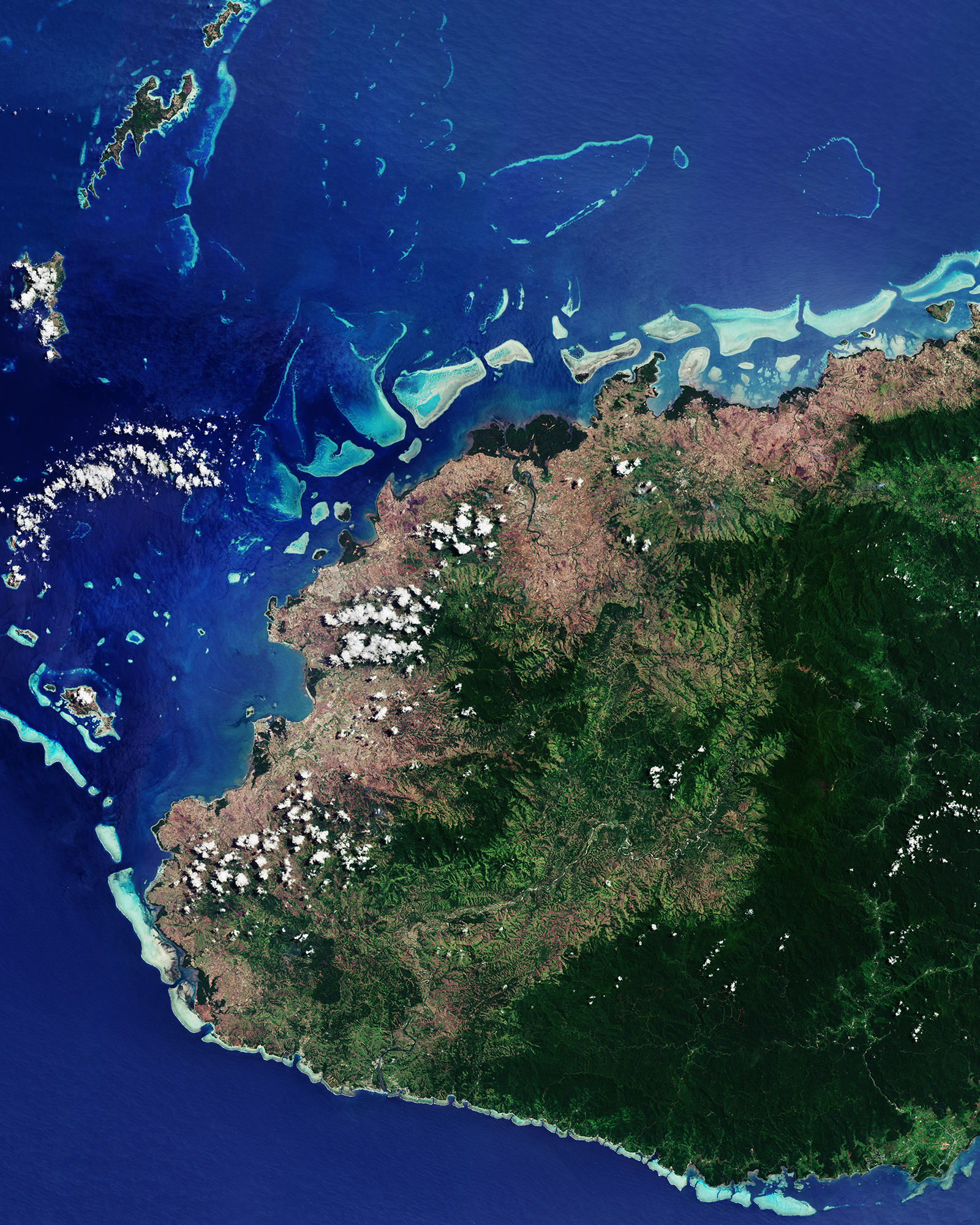
English: The Copernicus Sentinel-2B satellite takes us to the Republic of Fiji in the South Pacific Ocean on 28 September 2017. Part of Fiji’s largest island, Viti Levu, is pictured here, with coral reefs speckling the water.
Click on the box in the lower-right corner to view this image at its full 10 m resolution directly in your browser. Shaped by volcanic activity and earthquakes, the centre of the island is dominated by forests and a mountain range. The highest peak, Mount Tomanivi, reaches over 1320 m and is located on the central-right side of the image. While the area east of the mountain range receives heavy rainfall, the west side pictured here is in the ‘rain shadow’, meaning that the mountains block the rain clouds, leaving this area drier than the east. In addition to the human population of some 600 000, one of the largest insect species also resides on Viti Levu: the giant Fijian long-horned beetle. The island is the only known home to the beetle, which grows up to about 15 cm long – excluding antennae and legs. With more than 300 islands, the Fijian archipelago's low-lying coastal areas are at risk of sea-level rise – a devastating consequence of climate change. Satellites carry special instruments to measure sea-level rise – but not only. Different instruments can measure different climate variables, from greenhouse gases to melting glaciers, and offer a global view of the state of our planet. The Republic of Fiji holds the presidency for this year’s COP 23 (Conference of the Parties) on climate, held this week and next at the UN Framework Convention on Climate Change headquarters in Bonn, Germany. In February 2016, Cyclone Winston struck Fiji, damaging tens of thousands of homes and buildings, leaving more than 130 000 in need of shelter. With the COP 23 Presidency, Fiji calls for everyone to come together to build partnerships for climate action between governments, civil society and the private sector – and to work together to improve the climate resilience of vulnerable nations and communities. This image is featured on theEarth from Space video programme. |
| Date | |
| Source | http://www.esa.int/spaceinimages/Images/2017/11/Viti_Levu_Fiji |
| Author | European Space Agency |
| Permission (Reusing this file) |
contains modified Copernicus Sentinel data (2017), processed by ESA,CC BY-SA 3.0 IGO |
| Other versions |
|
| Title | Viti Levu, Fiji |
| System | Copernicus |
| Set | Earth observation image of the week |
| Mission | Sentinel-2 |
| Activity | Observing the Earth |

Licensing[edit]
- You are free:
- to share – to copy, distribute and transmit the work
- to remix – to adapt the work
- Under the following conditions:
- attribution – You must give appropriate credit, provide a link to the license, and indicate if changes were made. You may do so in any reasonable manner, but not in any way that suggests the licensor endorses you or your use.
- share alike – If you remix, transform, or build upon the material, you must distribute your contributions under the same or compatible license as the original.

|
This image contains data from a satellite in the Copernicus Programme, such as Sentinel-1, Sentinel-2 or Sentinel-3. Attribution is required when using this image.
Attribution: Contains modified Copernicus Sentinel data {{{year}}}
The use of Copernicus Sentinel Data is regulated under EU law (Commission Delegated Regulation (EU) No 1159/2013 and Regulation (EU) No 377/2014). Relevant excerpts:
Free access shall be given to GMES dedicated data [...] made available through GMES dissemination platforms [...].
Access to GMES dedicated data [...] shall be given for the purpose of the following use in so far as it is lawful:
GMES dedicated data [...] may be used worldwide without limitations in time.
GMES dedicated data and GMES service information are provided to users without any express or implied warranty, including as regards quality and suitability for any purpose. |
File history
Click on a date/time to view the file as it appeared at that time.
| Date/Time | Thumbnail | Dimensions | User | Comment | |
|---|---|---|---|---|---|
| current | 17:40, 10 November 2017 | | 1,600 × 2,000 (3.65 MB) | Fæ (talk | contribs) | European Space Agency, Id 386386, http://www.esa.int/spaceinimages/Images/2017/11/Viti_Levu_Fiji, User:Fæ/Project_list/ESA |
You cannot overwrite this file.
File usage on Commons
The following 2 pages use this file:
.jpg&redirect=no)