File:Volcán Paniri, Chile, 2016-02-09, DD 23.JPG

Original file (8,639 × 5,759 pixels, file size: 10.94 MB, MIME type: image/jpeg)
Captions
Captions
Summary
[edit]| Description |
Español: Vista del río San Pedro de Inacaliri con el volcán Paniri en el fondo, Provincia de El Loa, región de Antofagasta, norte de Chile, cerca de la frontera con Bolivia. Parini es un estratovolcán de una altura de 5960 m con una prominencia de 1653 m, mientras que el río San Pedro tiene una longitud de 76 km en una región extremadamente seca para desembocar en el río Loa.
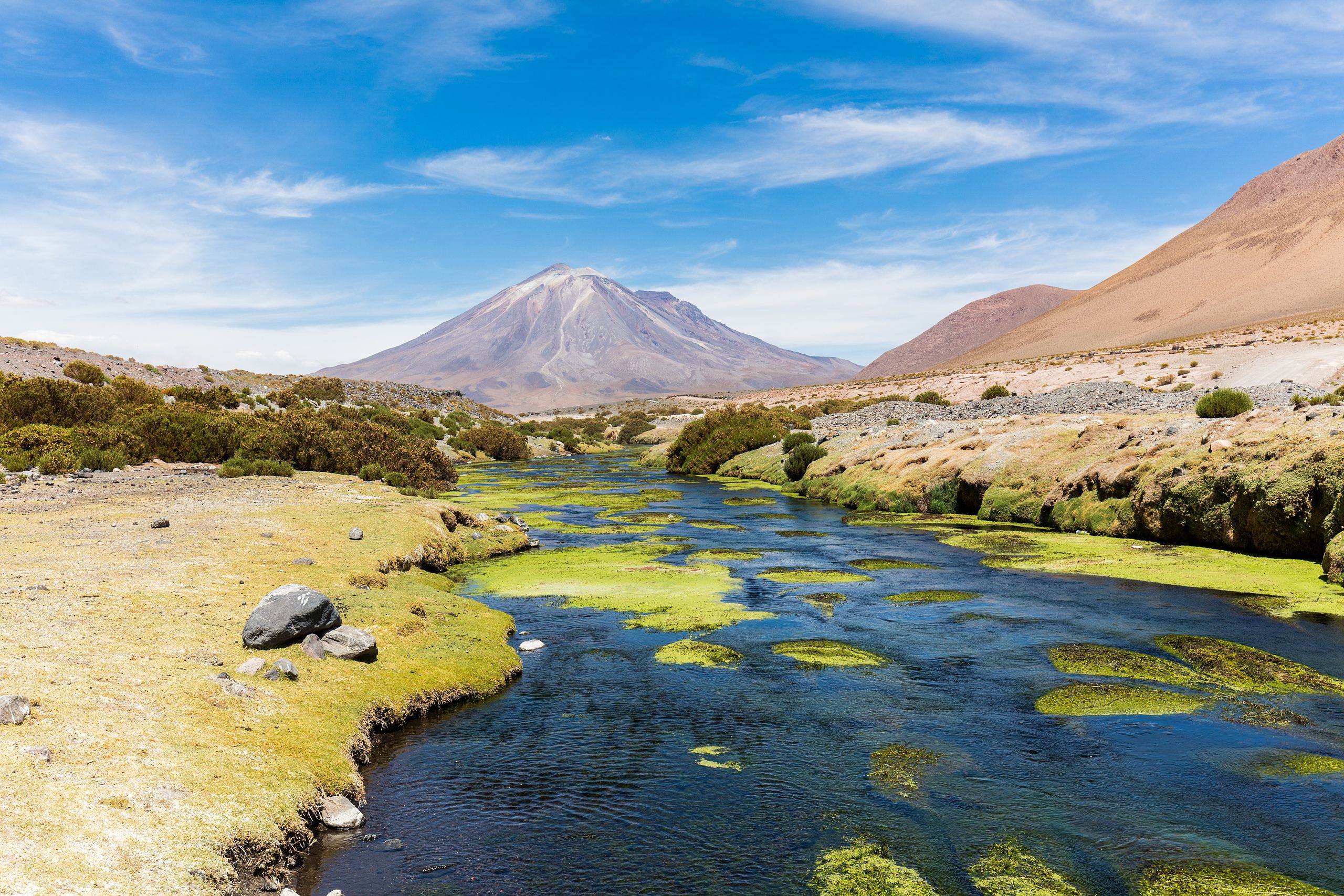
English: View of the San Pedro de Inacaliri River with the Paniri volcano in the background, El Loa Province, Antofagasta Region, northern Chile, close to the Bolivian border. Parini is a 5,960 metres (19,550 ft) high stratovolcano with a prominence of 1,653 metres (5,423 ft) whereas San Pedro River is a 76 kilometres (47 mi) long river in this extremely dry region ending in the Loa River.
Polski: Widok na rzekę San Pedro de Inacaliri oraz, w tle, wulkan Paniri położone w prowincji El Loa w regionie Antofagasta w północnym Chile, w pobliżu granicy z Boliwią. Paniri jest stratowulkanem o wysokości 5960 m n.p.m. i wybitności 1653 m, natomiast San Pedro ciągnie się w tym wyjątkowo suchym regionie przez 76 km i wpada do rzeki Loa.
Čeština: Pohled na řeku San Pedro de Inacaliri a sopku Paniri v pozadí, region Antofagasta, severní Chile. Vrchol stratovulkánu Parini má nadmořskou výšku 5 960 m.n.m. a vypíná se do výše 1 653 m nad okolní krajinu. Tok řeky San Pedro má délku 76 km a vlévá se do řeky Loa.
Magyar: A San Pedro de Inacaliri folyó az 5960 méter magas Paniri rétegvulkánnal a háttérben, Észak-Chilében, a bolíviai határ közelében (El Loa tartomány, Antofagasta régió)
Italiano: Vista del San Pedro de Inacaliri, un immissario del Loa, con il vulcano Paniri sullo sfondo.
Македонски: Поглед на реката Сан Педро де Инкалири со вулканот Панири во позадината. Покраина Ел Лоа, регион Антофагаста, северно Чиле.
Nederlands: De 76 kilometer lange rivier San Pedro de Inacaliri in Chili, met op de achtergrond de Paniri. Deze stratovulkaan is 5960 meter hoog en heeft een prominentie van 1653 meter.
Português: Vista do rio São Pedro de Inacaliri com o vulcão Paniri ao fundo, província de El Loa, região de Antofagasta, norte do Chile. |
||||||||||||||||||||
| Date | |||||||||||||||||||||
| Source | Own work | ||||||||||||||||||||
| Author |
|
||||||||||||||||||||

| Camera location | | View this and other nearby images on: OpenStreetMap |
|---|
Assessment
[edit]
|
This image has been assessed using the Quality image guidelines and is considered a Quality image.
|
This image was selected as picture of the day on Wikimedia Commons for 5 February 2017. It was captioned as follows: English: View of the San Pedro de Inacaliri River with the Paniri volcano in the background, El Loa Province, Antofagasta Region, northern Chile, close to the Bolivian border. Parini is a 5,960 metres (19,550 ft) high stratovolcano with a prominence of 1,653 metres (5,423 ft) whereas San Pedro River is a 76 kilometres (47 mi) long river in this extremely dry region ending in the Loa River. Other languages:
Čeština: Pohled na řeku San Pedro de Inacaliri a sopku Paniri v pozadí, region Antofagasta, severní Chile. Vrchol stratovulkánu Parini má nadmořskou výšku 5 960 m.n.m. a vypíná se do výše 1 653 m nad okolní krajinu. Tok řeky San Pedro má délku 76 km a vlévá se do řeky Loa. English: View of the San Pedro de Inacaliri River with the Paniri volcano in the background, El Loa Province, Antofagasta Region, northern Chile, close to the Bolivian border. Parini is a 5,960 metres (19,550 ft) high stratovolcano with a prominence of 1,653 metres (5,423 ft) whereas San Pedro River is a 76 kilometres (47 mi) long river in this extremely dry region ending in the Loa River. Español: Vista del río San Pedro de Inacaliri con el volcán Paniri en el fondo, Provincia de El Loa, región de Antofagasta, norte de Chile, cerca de la frontera con Bolivia. Parini es un estratovolcán de una altura de 5,960 m con una prominencia de 1,653 m, mientras que el río San Pedro tiene una longitud de 76 km en una región extremadamente seca para desembocar en el río Loa. Italiano: Vista del San Pedro de Inacaliri, un immissario del Loa, con il vulcano Paniri sullo sfondo. Magyar: A San Pedro de Inacaliri folyó az 5960 méter magas Paniri rétegvulkánnal a háttérben, Észak-Chilében, a bolíviai határ közelében (El Loa tartomány, Antofagasta régió) Nederlands: De 76 kilometer lange rivier San Pedro de Inacaliri in Chili, met op de achtergrond de Paniri. Deze stratovulkaan is 5960 meter hoog en heeft een prominentie van 1653 meter. Polski: Widok na rzekę San Pedro de Inacaliri oraz, w tle, wulkan Paniri położone w prowincji El Loa w regionie Antofagasta w północnym Chile, w pobliżu granicy z Boliwią. Paniri jest stratowulkanem o wysokości 5960 m n.p.m. i wybitności 1653 m, natomiast San Pedro ciągnie się w tym wyjątkowo suchym regionie przez 76 km i wpada do rzeki Loa. Português: Vista do rio São Pedro de Inacaliri com o vulcão Paniri ao fundo, província de El Loa, região de Antofagasta, norte do Chile. Македонски: Поглед на реката Сан Педро де Инкалири со вулканот Панири во позадината. Покраина Ел Лоа, регион Антофагаста, северно Чиле. |
Licensing
[edit]
Another one of my pictures: Want to see more works of mine? click here |
Under this condition:
Please, use this work legally fulfilling the terms of the license! Please, let me know if you use this work outside Wikimedia Commons sending me an email on Furthermore, if you:
please, do not hesitate to contact me. |

|
Please do not overwrite the author's version with a modified image without discussing with the author. The author would like to make corrections only from the uncompressed RAW file. This ensures that changes are preserved and are based on the best possible source to achieve a high quality. If you think that changes are required, please, get in touch with the author. Otherwise, you can upload a new image with a different name without overwriting this one. Use {{Derived from}} or {{Extracted from}} for this purpose. |
- You are free:
- to share – to copy, distribute and transmit the work
- to remix – to adapt the work
- Under the following conditions:
- attribution – You must give appropriate credit, provide a link to the license, and indicate if changes were made. You may do so in any reasonable manner, but not in any way that suggests the licensor endorses you or your use.
- share alike – If you remix, transform, or build upon the material, you must distribute your contributions under the same or compatible license as the original.
File history
Click on a date/time to view the file as it appeared at that time.
| Date/Time | Thumbnail | Dimensions | User | Comment | |
|---|---|---|---|---|---|
| current | 14:29, 5 May 2016 | | 8,639 × 5,759 (10.94 MB) | Poco a poco (talk | contribs) | User created page with UploadWizard |
You cannot overwrite this file.
File usage on Commons
The following 31 pages use this file:
- User:Daniel Mietchen/POTY/2016
- User:INeverCry/Favorites
- User:Jon Harald Søby/Liz
- User:Julian Herzog/Favorites
- User:Poco a poco/Chile
- User:Poco a poco/Nature
- User talk:Poco a poco/2016-06
- User talk:Poco a poco/2016-09
- Commons:Featured picture candidates/File:Volcán Paniri, Chile, 2016-02-09, DD 23.JPG
- Commons:Featured picture candidates/Log/June 2016
- Commons:Featured pictures/Places/Natural/Chile
- Commons:Featured pictures/chronological/2016-A
- Commons:Picture of the Year/2016/Candidates
- Commons:Picture of the Year/2016/R1/Gallery/2016-A
- Commons:Picture of the Year/2016/R1/Gallery/ALL
- Commons:Picture of the Year/2016/R1/Gallery/M06
- Commons:Picture of the Year/2016/R1/Gallery/Nature views
- Commons:Picture of the Year/2016/R1/v/Volcán Paniri, Chile, 2016-02-09, DD 23.JPG
- Commons:Quality images/Subject/Places/Natural structures/Panorama/Archive 2016
- Commons:Quality images candidates/Archives September 21 2016
- Template:Potd/2017-02
- Template:Potd/2017-02-05
- Template:Potd/2017-02-05 (cs)
- Template:Potd/2017-02-05 (en)
- Template:Potd/2017-02-05 (es)
- Template:Potd/2017-02-05 (hu)
- Template:Potd/2017-02-05 (it)
- Template:Potd/2017-02-05 (mk)
- Template:Potd/2017-02-05 (nl)
- Template:Potd/2017-02-05 (pl)
- Template:Potd/2017-02-05 (pt)
File usage on other wikis
The following other wikis use this file:
- Usage on be-tarask.wikipedia.org
- Usage on crh.wikipedia.org
- Usage on cv.wikipedia.org
- Usage on en.wikipedia.org
- Usage on eu.wikipedia.org
- Usage on fi.wikipedia.org
- Usage on fi.wikibooks.org
- Usage on fi.wikinews.org
- Usage on fi.wikiquote.org
- Usage on fi.wikisource.org
- Usage on fi.wikiversity.org
- Usage on fi.wikivoyage.org
- Usage on fi.wiktionary.org
- Usage on fr.wikipedia.org
- Usage on hu.wikipedia.org
- Usage on id.wikipedia.org
- Wikipedia:Gambar pilihan/2023
- Wikipedia:Gambar pilihan/Usulan/2023
- Wikipedia:Gambar pilihan/Usulan/2023/Periode 11
- Wikipedia:Gambar pilihan/44 2023
- Wikipedia:Arsip halaman utama/2023/06/22
- Wikipedia:Arsip halaman utama/2023/06/23
- Wikipedia:Arsip halaman utama/2023/06/24
- Wikipedia:Arsip halaman utama/2023/06/25
- Usage on ka.wikipedia.org
- Usage on ko.wikipedia.org
- Usage on lbe.wikipedia.org
- Usage on mk.wikipedia.org
- Usage on os.wikipedia.org
- Usage on pt.wikipedia.org
- Usage on ru.wikipedia.org
- Usage on ru.wikinews.org
- Usage on sah.wikipedia.org
- Usage on sv.wikipedia.org
- Usage on tt.wikipedia.org
- Usage on uk.wikipedia.org
- Usage on vi.wikipedia.org
View more global usage of this file.