File:Volga River (MODIS 2020-06-28).jpg

Original file (2,208 × 1,746 pixels, file size: 449 KB, MIME type: image/jpeg)
Captions
Captions
Summary
[edit].jpg&action=edit§ion=1)
| Description |
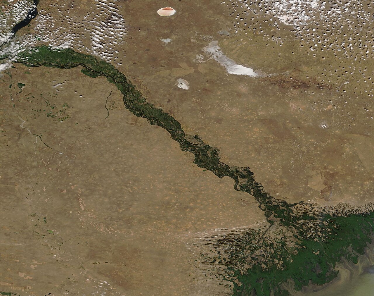
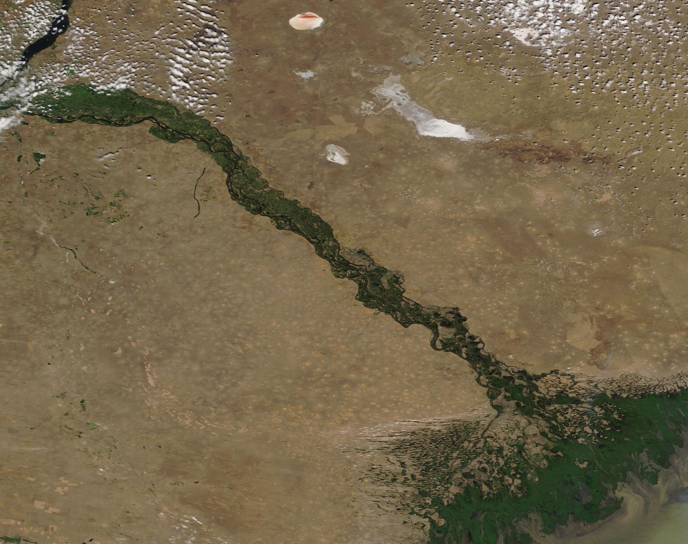
English: The beautiful braids of the Volga River fan into a broad delta on the northern shore of the Caspian Sea, creating a web of rich wetlands before spilling its water and sediment into the saline waters of the Sea. Rising from a small spring in the Valdai Hills about midway between St. Petersburg and Moscow, Russia, the Volga sweeps towards the southwest, creating a great arc measuring more than 1,671 mi (3690 km) before spilling into the Caspian Sea just south of the Kazakhstan border.
The longest river in Europe, the Volga has enormous economic, cultural, and environmental significance in the region. As the river approaches the Delta, water is carried in more than 500 twisting channels, creating a wetland that supports hundreds of species of birds, fish, and plants. The Volga River delta is one of the most productive regions of the world for fish, particularly caviar-producing sturgeon, 25 percent of which live in the Volga River. Four species of sturgeon live in the Volga River, the Russian sturgeon, starlet, stellate, and the one most famous for caviar – the beluga. Changes in water quality, environment, and dams have caused the population of sturgeon to drop dramatically—by about 90 percent—since 1970. On June 26, 2020, the Moderate Resolution Spectroradiometer (MODIS) on board NASA’s Terra satellite acquired a true-color image of the Volga River as it approaches the Caspian Sea. |
||
| Date | Taken on 26 June 2020 | ||
| Source |
|
||
| Author | MODIS Land Rapid Response Team, NASA GSFC |
| This media is a product of the Terra mission Credit and attribution belongs to the mission team, if not already specified in the "author" row |
Licensing
[edit].jpg&action=edit§ion=2)
| This file is in the public domain in the United States because it was solely created by NASA. NASA copyright policy states that "NASA material is not protected by copyright unless noted". (See Template:PD-USGov, NASA copyright policy page or JPL Image Use Policy.) | ||
 |
Warnings:
|
File history
Click on a date/time to view the file as it appeared at that time.
| Date/Time | Thumbnail | Dimensions | User | Comment | |
|---|---|---|---|---|---|
| current | 03:00, 17 February 2024 | | 2,208 × 1,746 (449 KB) | OptimusPrimeBot (talk | contribs) | #Spacemedia - Upload of http://modis.gsfc.nasa.gov/gallery/images/image06282020_250m.jpg via Commons:Spacemedia |
You cannot overwrite this file.
File usage on Commons
There are no pages that use this file.
.jpg&oldid=852773878)