File:Von Kármán Vortices in the Clouds off Guadalupe Island (MODIS 2022-05-19).jpg
Jump to navigation
Jump to search

Size of this preview: 789 × 599 pixels. Other resolutions: 316 × 240 pixels | 632 × 480 pixels | 1,011 × 768 pixels | 1,280 × 972 pixels | 2,658 × 2,019 pixels.
Original file (2,658 × 2,019 pixels, file size: 719 KB, MIME type: image/jpeg)
Captions
Captions
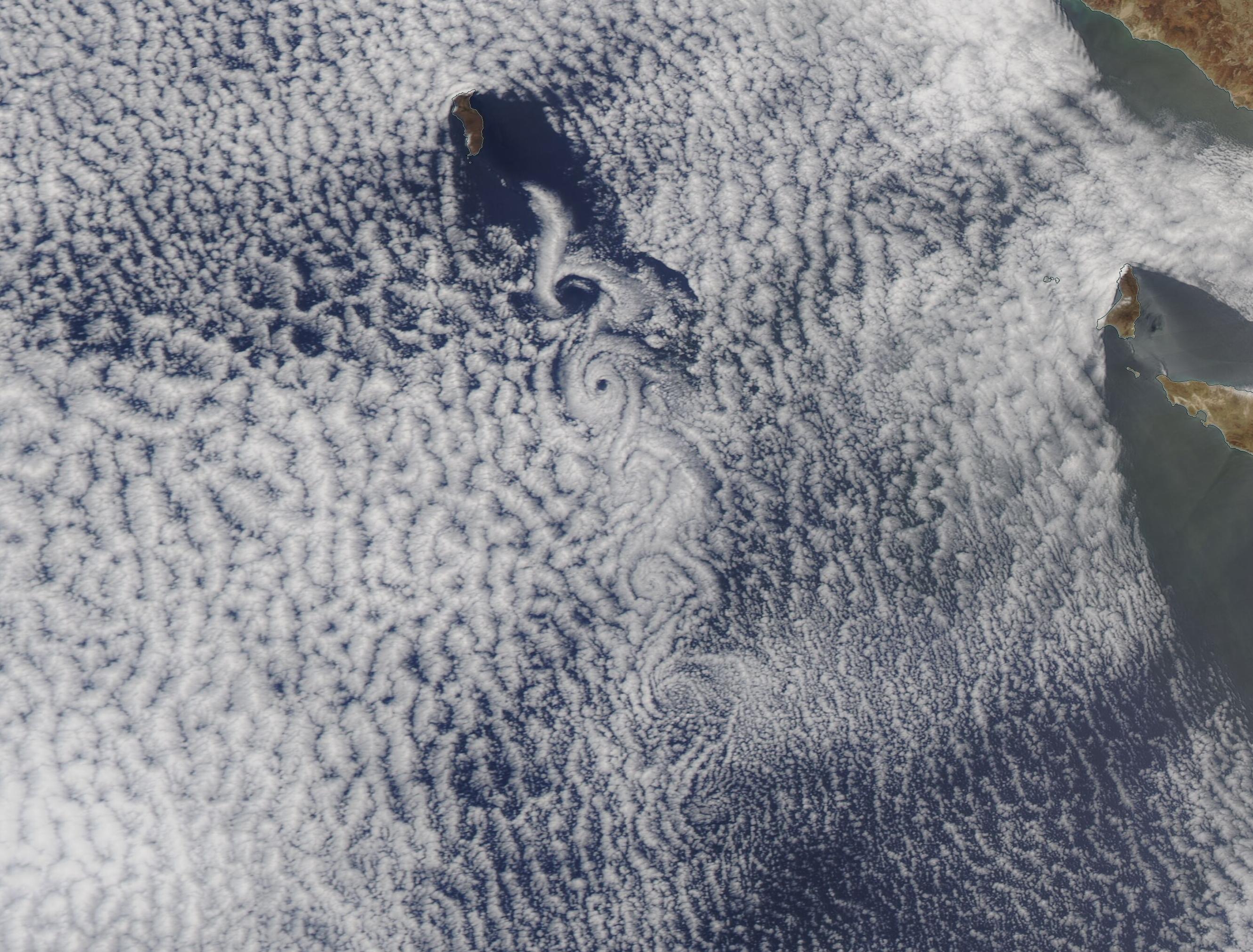
On May 17, 2022, the Moderate Resolution Imaging Spectroradiometer (MODIS) on board NASA’s Aqua satellite acquired a true-color image of stunningly beautiful swirls in a large bank of marine stratocumulus clouds near Guadalupe Island.
Summary
[edit].jpg&action=edit§ion=1)
| Description |
English: On May 17, 2022, the Moderate Resolution Imaging Spectroradiometer (MODIS) on board NASA’s Aqua satellite acquired a true-color image of stunningly beautiful swirls in a large bank of marine stratocumulus clouds near Guadalupe Island. The string of alternate swirls, which form string of paisley-like patterns on the lee side of Guadalupe Island are called “von Kármán vortices” and arise when winds are diverted around a blunt, high-profile object, often an island rising from the ocean. The alternating direction of rotation in the air forms swirls in the clouds. Such vortices were first described in 1912 by physicist Theodore von Kármán.
Guadalupe Island sits in the Pacific Ocean about 150 miles off of the coast of Mexico’s Baja California. Only 21 miles (35 km) long, the highest point, Mount Augusta, soars to 4,257 feet (1,297 meters—creating a significant impediment to the movement of wind blowing by it over an otherwise nearly-flat ocean surface. When rushing water slams into an immobile object—such as a dock piling—it’s easy to see that turbulence is created, leaving swirls behind the piling. Principals of fluid motion also apply to the atmosphere, so when winds are diverted around an immobile object, such as a tall mountain on an island, turbulence is created on the lee side (the side away from the motion of the wind). Since air is invisible, this atmospheric ocean is only visible when clouds fill the sky. |
||
| Date | Taken on 17 May 2022 | ||
| Source |
Von Kármán Vortices in the Clouds off Guadalupe Island (direct link)
|
||
| Author | MODIS Land Rapid Response Team, NASA GSFC |
| This media is a product of the Aqua mission Credit and attribution belongs to the mission team, if not already specified in the "author" row |
Licensing
[edit].jpg&action=edit§ion=2)
| This file is in the public domain in the United States because it was solely created by NASA. NASA copyright policy states that "NASA material is not protected by copyright unless noted". (See Template:PD-USGov, NASA copyright policy page or JPL Image Use Policy.) | ||
 |
Warnings:
|
File history
Click on a date/time to view the file as it appeared at that time.
| Date/Time | Thumbnail | Dimensions | User | Comment | |
|---|---|---|---|---|---|
| current | 22:04, 9 January 2024 | | 2,658 × 2,019 (719 KB) | OptimusPrimeBot (talk | contribs) | #Spacemedia - Upload of http://modis.gsfc.nasa.gov/gallery/images/image05192022_250m.jpg via Commons:Spacemedia |
You cannot overwrite this file.
File usage on Commons
There are no pages that use this file.
.jpg&oldid=880563726)