File:Waddell Dam, Lake Pleasant, North of Phoenix, Arizona (101298853).jpg
Original file (1,600 × 1,200 pixels, file size: 685 KB, MIME type: image/jpeg)
Captions
Captions
Summary
[edit].jpg&action=edit§ion=1)
| Description |
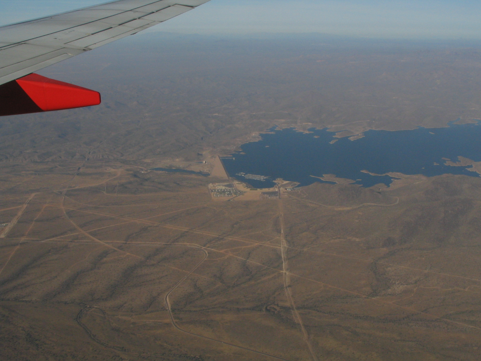
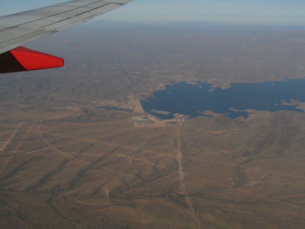
Lake Pleasant Regional Park is a large outdoors recreation area straddling the Maricopa and Yavapai county border northwest of Phoenix, Arizona. The park is located within the municipal boundaries of Peoria, Arizona, and serves as a major recreation hub for the northwest Phoenix metropolitan area. The cornerstone of the park is the 10,000 acre (40 km² or 15.6 mi²), Lake Pleasant, one of the important artificial reservoirs surrounding the Phoenix metropolitan area. Created by the Waddell (Pleasant) Dam, which was finished in 1927, the lake originally had a surface area of 3,700 acres (15 km² or 5.8 mi²) and served as a private irrigation project. At 76 feet (23 m) high and 2,160 feet (658 m) long, the original Waddell Dam was, at its completion, the largest agricultural dam project in the world. The lake was filled by the Agua Fria River, capturing a large watershed throughout Yavapai County. Construction of the Central Arizona Project Aqueduct, which began in 1973, soon diverted water from the Colorado River to the lake, converting the lake from an agricultural project into a storage reservoir for the project. Completed in 1994, the New Waddell Dam tripled the surface area of the lake, submerging the old dam beneath its waters. Shortly after the completion of the dam, the area experienced a prolonged drought, and while the lake grew considerably it would not reach full capacity until early 2005. Although still fed by the Agua Fria River, the CAP aqueduct is the primary source of water for the reservoir. Lake Pleasant is used as a major water sports recreation center for the Phoenix metro area, as well as serving as an important storage reservoir for the rapidly growing region. A number of boat docks and beach access make the lake a popular destination for scuba diving, water skiing, jet skiing, sailing, windsurfing and other water sports. en.wikipedia.org/wiki/Lake_Pleasant_Regional_Park en.wikipedia.org/wiki/Wikipedia:Text_of_Creative_Commons_... |
| Date | |
| Source | Waddell Dam, Lake Pleasant, North of Phoenix, Arizona |
| Author | Ken Lund from Reno, Nevada, USA |
| Camera location | | View this and other nearby images on: OpenStreetMap |
|---|
.jpg¶ms=033.848177_N_-112.267055_E_globe:Earth_type:camera_source:Flickr_&language=en)
Licensing
[edit].jpg&action=edit§ion=2)
- You are free:
- to share – to copy, distribute and transmit the work
- to remix – to adapt the work
- Under the following conditions:
- attribution – You must give appropriate credit, provide a link to the license, and indicate if changes were made. You may do so in any reasonable manner, but not in any way that suggests the licensor endorses you or your use.
- share alike – If you remix, transform, or build upon the material, you must distribute your contributions under the same or compatible license as the original.
| This image was originally posted to Flickr by Ken Lund at https://flickr.com/photos/75683070@N00/101298853. It was reviewed on 3 December 2015 by FlickreviewR and was confirmed to be licensed under the terms of the cc-by-sa-2.0. |
File history
Click on a date/time to view the file as it appeared at that time.
| Date/Time | Thumbnail | Dimensions | User | Comment | |
|---|---|---|---|---|---|
| current | 21:41, 3 December 2015 | | 1,600 × 1,200 (685 KB) | INeverCry (talk | contribs) | Transferred from Flickr via Flickr2Commons |
You cannot overwrite this file.
File usage on Commons
There are no pages that use this file.
.jpg&oldid=907398911)