File:Wales location map.svg
পরিভ্রমণে চলুন
অনুসন্ধানে চলুন

এই SVG ফাইলের জন্য এই PNG প্রাকদর্শনের আকার: ৫০১ × ৫৯৯ পিক্সেল। অন্যান্য আকারসমূহ: ২০১ × ২৪০ পিক্সেল | ৪০১ × ৪৮০ পিক্সেল | ৬৪২ × ৭৬৮ পিক্সেল | ৮৫৬ × ১,০২৪ পিক্সেল | ১,৭১৩ × ২,০৪৮ পিক্সেল | ১,০৪৭ × ১,২৫২ পিক্সেল।
মূল ফাইল (এসভিজি ফাইল, সাধারণত ১,০৪৭ × ১,২৫২ পিক্সেল, ফাইলের আকার: ২৩৭ কিলোবাইট)
ক্যাপশনসমূহ
ক্যাপশন
এই ফাইল কি প্রতিনিধিত্ব করছে তার এক লাইন ব্যাখ্যা যোগ করুন
সারাংশ[সম্পাদনা]
| বিবরণ |
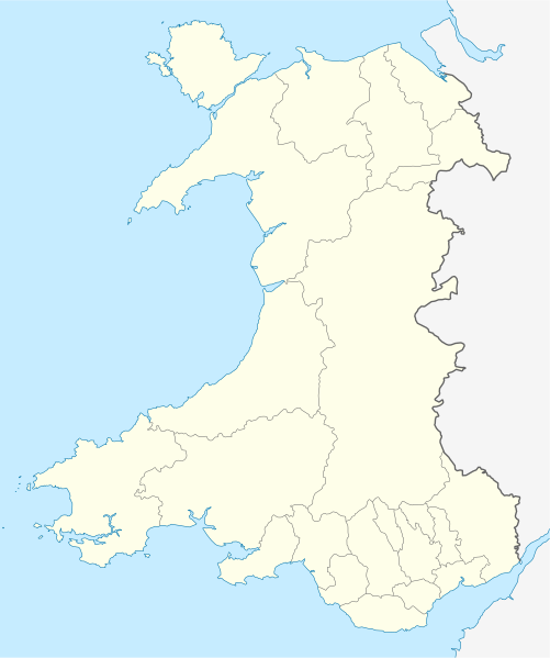
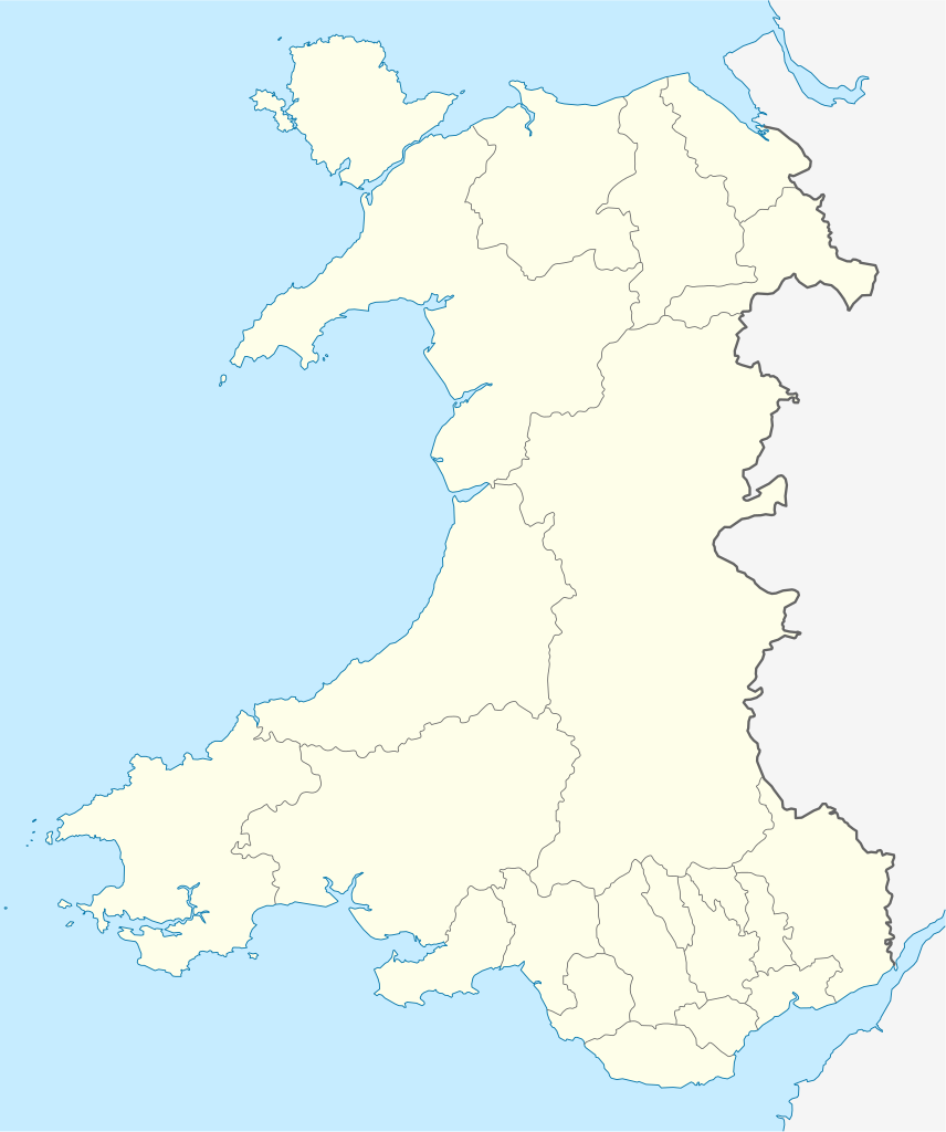
Quadratische Plattkarte, N-S-Streckung 163 %. Geographische Begrenzung der Karte:
Equirectangular projection, N/S stretching 163 %. Geographic limits of the map:
|
| তারিখ | |
| উৎস | own work, using United States National Imagery and Mapping Agency data |
| লেখক | NordNordWest |
| অন্যান্য সংস্করণ |
এই ফাইলের উপজাত কর্মসমূহ: |

|
এই মানচিত্রটি জার্মান Kartenwerkstatt-এ (মানচিত্র ল্যাব) উন্নতি বা তৈরি করা হয়েছে। আপনিও উন্নতি করার জন্য মানচিত্র প্রস্তাব করতে পারেন।
|
লাইসেন্স প্রদান[সম্পাদনা]
আমি, এই কাজের স্বত্বাধিকারী, এতদ্দ্বারা আমি এই কাজকে নিম্ন বর্ণিত লাইসেন্সের আওতায় প্রকাশ করলাম:
এই ফাইলটি ক্রিয়েটিভ কমন্স অ্যাট্রিবিউশন-শেয়ার অ্যালাইক ৩.০ আনপোর্টেড লাইসেন্সের আওতায় লাইসেন্সকৃত।
- আপনি স্বাধীনভাবে:
- বণ্টন করতে পারেন – এ কাজটি অনুলিপি, বিতরণ এবং প্রেরণ করতে পারেন
- পুনঃমিশ্রণ করতে পারেন – কাজটি অভিযোজন করতে পারেন
- নিম্নের শর্তাবলীর ভিত্তিতে:
- স্বীকৃতিপ্রদান – আপনাকে অবশ্যই যথাযথ স্বীকৃতি প্রদান করতে হবে, লাইসেন্সের একটি লিঙ্ক সরবরাহ করতে হবে এবং কোনো পরিবর্তন হয়েছে কিনা তা নির্দেশ করতে হবে। আপনি যেকোনো যুক্তিসঙ্গত পদ্ধতিতে এটি করতে পারেন। কিন্তু এমন ভাবে নয়, যাতে প্রকাশ পায় যে লাইসেন্সধারী আপনাকে বা আপনার এই ব্যবহারের জন্য অনুমোদন দিয়েছে।
- একইভাবে বণ্টন – আপনি যদি কাজটি পুনঃমিশ্রণ, রুপান্তর, বা এর ওপর ভিত্তি করে নতুন সৃষ্টিকর্ম তৈরি করেন, তবে আপনাকে অবশ্যই আপনার অবদান একই লাইসেন্স বা একই রকমের লাইসেন্সের আওতায় বিতরণ করতে হবে।
ফাইলের ইতিহাস
যেকোনো তারিখ/সময়ে ক্লিক করে দেখুন ফাইলটি তখন কী অবস্থায় ছিল।
| তারিখ/সময় | সংক্ষেপচিত্র | মাত্রা | ব্যবহারকারী | মন্তব্য | |
|---|---|---|---|---|---|
| বর্তমান | ১৩:২৭, ২৪ জুন ২০০৯ | | ১,০৪৭ × ১,২৫২ (২৩৭ কিলোবাইট) | NordNordWest (আলোচনা | অবদান) | {{Information |Description= {{de|Positionskarte von Wales, Vereinigtes Königreich}} Quadratische Plattkarte, N-S-Streckung 163 %. Geographische Begrenzung der Karte: * N: 53.5° N * S: 51.3° N * W: 5.5° W * |
আপনি এই ফাইলটি প্রতিস্থাপন করতে পারবেন না।
ফাইলের ব্যবহার
এই ফাইলের সাথে ১০০টির বেশি পাতার লিংক রয়েছে। নিচের তালিকায় ফাইলের সাথে যুক্ত প্রথম ১০০টি পাতার লিংক দেখানো হচ্চে। এছাড়া একটি পূর্ণাঙ্গ তালিকাও রয়েছে।
- User:NordNordWest/Gallery/Location maps
- File:2023 North East Wales National Park (Area of Search) draft map.svg
- File:A470-Wales.svg
- File:All-Wales Orange Map.svg
- File:Anglesey in Wales.svg
- File:Blaenau Gwent in Wales.svg
- File:Bridgend in Wales.svg
- File:Caerphilly in Wales.svg
- File:Cardiff in Wales.svg
- File:Carmarthenshire in Wales.svg
- File:Ceredigion in Wales.svg
- File:Clwyd Preserved County in Wales.svg
- File:Clwydian Range and Dee Valley AONB map.svg
- File:Clwydian Range and Dee Valley AONB stages map.svg
- File:Conwy in Wales.svg
- File:Denbighshire in Wales.svg
- File:Dyfed Preserved County in Wales.svg
- File:Flintshire in Wales.svg
- File:Gwent Preserved County in Wales.svg
- File:Gwynedd Preserved County in Wales.svg
- File:Gwynedd in Wales.svg
- File:Map of Owain Glyndŵr's Revolt.svg
- File:Merthyr Tydfil in Wales.svg
- File:Mid Glamorgan Preserved County in Wales.svg
- File:Mid Wales.svg
- File:Mid and South West Wales Map.svg
- File:Mid and West Wales Fire and Rescue Map.svg
- File:Monmouthshire in Wales.svg
- File:NUTS 2 statistical regions of the United Kingdom 2015 map.svg
- File:NUTS 2 statistical regions of the United Kingdom map.svg
- File:NUTS 3 regions of Wales map.svg
- File:Neath Port Talbot in Wales.svg
- File:Newport in Wales.svg
- File:North East Wales Map.svg
- File:North Wales Fire and Rescue Map.svg
- File:North Wales Map.svg
- File:North West Wales.svg
- File:North and Mid Wales map.svg
- File:Pembrokeshire in Wales.svg
- File:Powys Preserved County in Wales.svg
- File:Powys in Wales.svg
- File:Preserved Counties Wales.svg
- File:Rhondda Cynon Taf in Wales.svg
- File:South East Wales.svg
- File:South East and South West Wales map.svg
- File:South Glamorgan Preserved County in Wales.svg
- File:South Wales Fire and Rescue Map.svg
- File:South Wales Map.svg
- File:South West Wales.svg
- File:Swanline Map.png
- File:Swansea District line Map.png
- File:Swansea in Wales.svg
- File:Torfaen in Wales.svg
- File:Vale of Glamorgan in Wales.svg
- File:Wales AONBs map.svg
- File:Wales AONBs map (with local boundaries).svg
- File:Wales Bridgend.svg
- File:Wales Cardiff Capital Region locator map.svg
- File:Wales Carmarthenshire.svg
- File:Wales Ceredigion.svg
- File:Wales City Regions map.svg
- File:Wales Fire and Rescue Services map.svg
- File:Wales Historic Counties map.svg
- File:Wales Historic Counties map Anglesey.svg
- File:Wales Historic Counties map Brecknockshire.svg
- File:Wales Historic Counties map Caernarfonshire.svg
- File:Wales Historic Counties map Cardiganshire.svg
- File:Wales Historic Counties map Carmarthenshire.svg
- File:Wales Historic Counties map Denbighshire.svg
- File:Wales Historic Counties map Flintshire.svg
- File:Wales Historic Counties map Glamorgan.svg
- File:Wales Historic Counties map Merionethshire.svg
- File:Wales Historic Counties map Monmouthshire.svg
- File:Wales Historic Counties map Montgomeryshire.svg
- File:Wales Historic Counties map Pembrokeshire.svg
- File:Wales Historic Counties map Radnorshire.svg
- File:Wales Map 400 x 478.png
- File:Wales Merthyr Tydfil.svg
- File:Wales Mid Wales locator map.svg
- File:Wales National Parks and AONBs map.svg
- File:Wales National Parks and AONBs map (colours).svg
- File:Wales National Parks and AONBs map (colours and labelled).svg
- File:Wales National Parks and AONBs map (labelled).svg
- File:Wales National Parks map.svg
- File:Wales Neath Port Talbot.svg
- File:Wales North Wales locator map.svg
- File:Wales Pembrokeshire.svg
- File:Wales Powys.svg
- File:Wales Principal Areas Density Map.svg
- File:Wales Principal Areas map (in green).svg
- File:Wales Rhondda Cynon Taf.svg
- File:Wales Swansea.svg
- File:Wales Swansea Bay City Region locator map.svg
- File:Wales Trunk Road Agents map.svg
- File:Wales Vale of Glamorgan.svg
- File:Wales location map subdivisions 1996.svg
- File:Welsh weekly newspapers.jpg
- File:West Glamorgan Preserved County in Wales.svg
- File:West Wales lines Map.png
- File:Wild Wales map.svg
_draft_map.svg)
.svg)
.svg)
.svg)
.svg)
.svg)
এই ফাইলের আরও লিঙ্ক দেখাও।
ফাইলের বৈশ্বিক ব্যবহার
নিচের অন্যান্য উইকিগুলো এই ফাইলটি ব্যবহার করে:
- af.wikipedia.org-এ ব্যবহার
- ar.wikipedia.org-এ ব্যবহার
- ast.wikipedia.org-এ ব্যবহার
- az.wikipedia.org-এ ব্যবহার
- ba.wikipedia.org-এ ব্যবহার
- bg.wikipedia.org-এ ব্যবহার
- bh.wikipedia.org-এ ব্যবহার
- bn.wikipedia.org-এ ব্যবহার
- br.wikipedia.org-এ ব্যবহার
- Dolgellau
- Bangor-is-y-coed
- Aberaeron
- Patrom:Infobox UK place
- Rhaeadr Gwy
- Llanfachraeth (Mon)
- Trefor (Mon)
- Caergybi
- Aberporth
- Beulah (Ceredigion)
- Llanfihangel-yn-Nhywyn
- Abermaw
- Llan-faes (Mon)
- Ynyslas
- Clynnog Fawr
- Ffair-rhos
- Patrom:Location map Kembre
- Bont Goch
- Gilfachreda
- Parc-llyn
- Pennant (Ceredigion)
- Brongest
- Bryngwyn (Ceredigion)
- Brynafan
- Brynhoffnant
- Coed-y-bryn
- Cwmsychbant
এই ফাইলের অন্যান্য বৈশ্বিক ব্যবহার দেখুন।