File:Walter William Ristow 283-3-004 (3x4 crop).jpg
Jump to navigation
Jump to search

Size of this preview: 450 × 600 pixels. Other resolutions: 180 × 240 pixels | 360 × 480 pixels | 576 × 768 pixels | 1,182 × 1,576 pixels.
Original file (1,182 × 1,576 pixels, file size: 448 KB, MIME type: image/jpeg)
Captions
Captions
Add a one-line explanation of what this file represents
Summary[edit]
| Français : Troisième congrès annuel de l’Association des cartothèques et archives cartographiques du Canada
English: Third Annual Meeting of the Association of Canadian Map Libraries and Archives ( |
|||||||||||||||||||||||||||
|---|---|---|---|---|---|---|---|---|---|---|---|---|---|---|---|---|---|---|---|---|---|---|---|---|---|---|---|
| Photographer |
Yves Tessier |
||||||||||||||||||||||||||
| Title |
Français : Troisième congrès annuel de l’Association des cartothèques et archives cartographiques du Canada
English: Third Annual Meeting of the Association of Canadian Map Libraries and Archives |
||||||||||||||||||||||||||
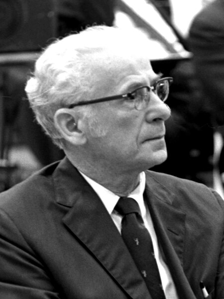
| Description |
Français : Troisième congrès annuel de l’Association des cartothèques et archives cartographiques du Canada tenu à la Bibliothèque de l’Université Laval en juin 1969 et organisé par Yves Tessier, chef de la Cartothèque et un des quatre fondateurs de l’association en 1967. Une grande primeur dévoilée à Québec.
Walter Ristow et son adjoint ont rendu public au congrès annuel les toute premières notices catalographiques pour les cartes géographiques compilées selon le tout nouveau format MARC (machine readeable catalog) pour les cartes géographiques développé par la Library of Congress. Ils ont laissé une grande bobine magnétique contenant les premiers documents électroniques du genre ainsi qu’un listing imprimé sur papier en continu. Walter Ristow parmi l’assistance. English: Third annual conference of the Association of Map Libraries and Cartographic Archives of Canada held at the Université Laval Library in June 1969 and organized by Yves Tessier, head of the Map Library and one of the four founders of the association in 1967. A great deal premier unveiled in Quebec.
Walter Ristow and his deputy released at the annual convention the very first catalog records for geographic maps compiled in the brand new MARC (machine readeable catalog) format for geographic maps developed by the Library of Congress. They left behind a large magnetic reel containing the first electronic documents of its kind as well as a continuous printed listing. Walter Ristow in the audience. |
||||||||||||||||||||||||||
| Depicted people | Walter William Ristow | ||||||||||||||||||||||||||
| Date | June 1969 | ||||||||||||||||||||||||||
| Collection |
|
||||||||||||||||||||||||||
| Current location |
Français : Division de la gestion des documents administratifs et des archives |
||||||||||||||||||||||||||
| Accession number |
283-3-004 |
||||||||||||||||||||||||||
| Source |
|
||||||||||||||||||||||||||
| Permission (Reusing this file) |
This file is licensed under the Creative Commons Attribution-Share Alike 4.0 International license.
|
||||||||||||||||||||||||||
| Other versions | |||||||||||||||||||||||||||


.jpg&action=edit§ion=1)
File history
Click on a date/time to view the file as it appeared at that time.
| Date/Time | Thumbnail | Dimensions | User | Comment | |
|---|---|---|---|---|---|
| current | 23:49, 28 February 2023 | | 1,182 × 1,576 (448 KB) | Animalparty (talk | contribs) | File:Walter William Ristow 283-3-004.jpg cropped 72 % horizontally, 41 % vertically using CropTool with lossless mode. |
You cannot overwrite this file.
File usage on Commons
The following 2 pages use this file:
.jpg)
.jpg&oldid=850558907)